| [3] |
Name on the Register[4] |
Image |
Date listed[5] |
Location |
City or town |
Description |
|---|
| 1 |
Archeological Site SMA-151 |
Upload image |
000000001978-02-23-0000February 23, 1978
(#78000771) |
Address Restricted
|
Princeton |
|
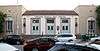
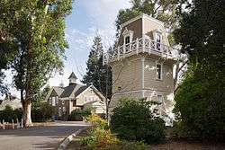
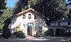
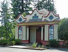
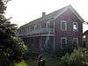
| 2 |
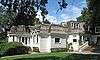
Barron-Latham-Hopkins Gate Lodge |
|
000000001986-08-28-0000August 28, 1986
(#86001951) |
555 Ravenswood Ave.
37°27′18″N 122°10′42″W / 37.455°N 122.178333°W / 37.455; -122.178333 (Barron-Latham-Hopkins Gate Lodge) |
Menlo Park |
|
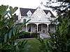
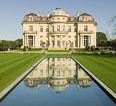
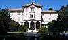
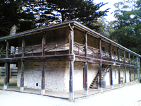
| 3 |
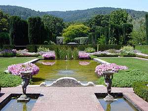
Bourn-Roth Estate |
|
000000001975-08-28-0000August 28, 1975
(#75000479) |
3.7 mi. northwest of Woodside off Canada Rd.
37°28′13″N 122°18′39″W / 37.470278°N 122.310833°W / 37.470278; -122.310833 (Bourn-Roth Estate) |
Woodside |
Also known as Filoli; built in 1915 by Willis Polk for mining magnate William Bourn, owner of the Empire Mine in Grass Valley, California[6]
|
| 4 |
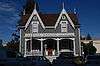
Nathanial Brittan Party House |
|
000000001994-12-29-0000December 29, 1994
(#94001500) |
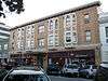
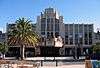
125 Dale Ave.
37°30′02″N 122°16′15″W / 37.500556°N 122.270833°W / 37.500556; -122.270833 (Nathanial Brittan Party House) |
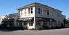
San Carlos |
|
| 5 |
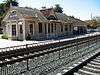
Burlingame Railroad Station |
|
000000001978-04-19-0000April 19, 1978
(#78000769) |
Burlingame Ave. and California Dr.
37°34′49″N 122°20′38″W / 37.580278°N 122.343889°W / 37.580278; -122.343889 (Burlingame Railroad Station) |
Burlingame |
|
| 6 |
The Carolands |
|
000000001975-10-21-0000October 21, 1975
(#75000478) |
565 Remillard Dr.
37°33′20″N 122°22′15″W / 37.555556°N 122.370833°W / 37.555556; -122.370833 (The Carolands) |
Hillsborough |
1914 home of Harriet Pullman Carolan, daughter of George Pullman, inventor of the Pullman sleeping car; built by Willis Polk
|
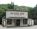
| 7 |
Casa de Tableta |
|
000000001973-08-14-0000August 14, 1973
(#73000447) |
3915 Alpine Rd.
37°22′56″N 122°11′34″W / 37.382222°N 122.192778°W / 37.382222; -122.192778 (Casa de Tableta) |
Portola Valley |
Now Alpine Inn, formerly known as Rossotti's Saloon since the 1850s.
|
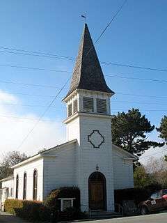
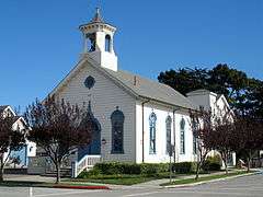
| 8 |
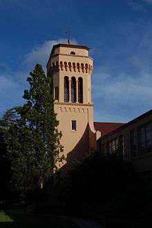
Church of the Nativity |
|
000000001980-10-31-0000October 31, 1980
(#80000855) |
210 Oak Grove Ave.
37°27′39″N 122°10′46″W / 37.460833°N 122.179444°W / 37.460833; -122.179444 (Church of the Nativity) |
Menlo Park |
|
| 9 |
Ernest Coxhead House |
|
000000002000-04-06-0000April 6, 2000
(#00000322) |
37 E. Santa Inez Ave.
37°34′13″N 122°19′54″W / 37.570278°N 122.331667°W / 37.570278; -122.331667 (Ernest Coxhead House) |
San Mateo |
|
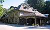
| 10 |
Eugene J. de Sabla, Jr., Teahouse and Tea Garden |
|
000000001992-07-30-0000July 30, 1992
(#92000965) |
70 De Sabla Ave.
37°33′55″N 122°19′49″W / 37.565278°N 122.330278°W / 37.565278; -122.330278 (Eugene J. de Sabla, Jr., Teahouse and Tea Garden) |
San Mateo |
Circa 1907 Japanese farmhouse-style teahouse built for Eugene de Sabla, a co-founder of Pacific Gas and Electric Company[7]
|
| 11 |
Dickerman Barn |
|
000000001982-01-11-0000January 11, 1982
(#82002259) |
Cabrillo Hwy.
37°07′09″N 122°18′21″W / 37.119167°N 122.305833°W / 37.119167; -122.305833 (Dickerman Barn) |
Pescadero |
|
| 12 |
John Dielmann House |
Upload image |
000000002015-10-06-0000October 6, 2015
(#15000681) |
1020 Main St.
37°29′01″N 122°13′34″W / 37.4836°N 122.2261°W / 37.4836; -122.2261 (John Dielmann House) |
Redwood City |
|
| 13 |
First Congregational Church of Pescadero |
|
000000001980-10-31-0000October 31, 1980
(#80000856) |
San Gregorio St.
37°15′16″N 122°22′56″W / 37.254444°N 122.382222°W / 37.254444; -122.382222 (First Congregational Church of Pescadero) |
Pescadero |
|
| 14 |
Folger Estate Stable Historic District |
|
000000002004-04-16-0000April 16, 2004
(#04000328) |
4040 Woodside Rd.
37°24′30″N 122°15′29″W / 37.408333°N 122.258056°W / 37.408333; -122.258056 (Folger Estate Stable Historic District) |
Woodside |
|
| 15 |
Golden Gate National Cemetery |
|
000000002016-03-08-0000March 8, 2016
(#16000058) |
1300 Sneath Ln.
37°38′07″N 122°25′52″W / 37.635278°N 122.431111°W / 37.635278; -122.431111 (Golden Gate National Cemetery) |
San Bruno |
|
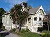
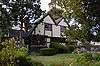
| 16 |
Green Gables-Mortimer Fleishhacker Country House |
Upload image |
000000001986-09-26-0000September 26, 1986
(#86002396) |
329 Albion Ave.
37°25′59″N 122°16′02″W / 37.433056°N 122.267222°W / 37.433056; -122.267222 (Green Gables-Mortimer Fleishhacker Country House) |
Woodside |
1911 Arts and Crafts vacation home designed by Charles Sumner Greene[8]
|
| 17 |
Green Oaks Ranch House |
Upload image |
000000001976-11-21-0000November 21, 1976
(#76000526) |
13 mi. S of Pescadero on CA 1
37°08′04″N 122°18′38″W / 37.134444°N 122.310556°W / 37.134444; -122.310556 (Green Oaks Ranch House) |
Pescadero |
|
| 18 |
Arthur and Mona Hofmann House |
|
000000001991-08-05-0000August 5, 1991
(#91000926) |
1048 La Cuesta Rd.
37°33′03″N 122°20′53″W / 37.550833°N 122.348056°W / 37.550833; -122.348056 (Arthur and Mona Hofmann House) |
Hillsborough |
|
| 19 |
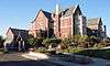
Holbrook-Palmer Estate, "Elmwood" |
|
000000002016-09-26-0000September 26, 2016
(#16000663) |
150 Watkins Ave.
37°27′49″N 122°11′29″W / 37.463654°N 122.191419°W / 37.463654; -122.191419 (Holbrook-Palmer Estate, "Elmwood") |
Atherton |
|
| 20 |
Hotel St. Matthew |
|
000000001998-01-23-0000January 23, 1998
(#97001663) |
215-229 Second Ave.
37°33′58″N 122°19′26″W / 37.566111°N 122.323889°W / 37.566111; -122.323889 (Hotel St. Matthew) |
San Mateo |
|
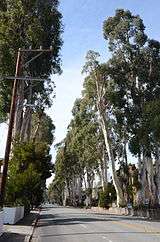
| 21 |
Howard-Ralston Eucalyptus Tree Rows |
|
000000002012-03-15-0000March 15, 2012
(#12000127) |
El Camino Real, CA 82
37°34′54″N 122°21′43″W / 37.581725°N 122.361996°W / 37.581725; -122.361996 (Howard-Ralston Eucalyptus Tree Rows) |
Burlingame |
|
| 22 |
Independence Hall |
|
000000001978-08-03-0000August 3, 1978
(#78000772) |
2955 Woodside Rd.
37°25′43″N 122°15′37″W / 37.428644°N 122.260325°W / 37.428644; -122.260325 (Independence Hall) |
Woodside |
1884 building that was located at 129 Albion Ave. when added to the National Register. It is now located adjacent to Woodside Town Hall at 2955 Woodside Rd.[9]
|
| 23 |
James Johnston House |
|
000000001973-05-09-0000May 9, 1973
(#73000446) |
Higgins-Purisima Rd.
37°26′59″N 122°25′20″W / 37.449722°N 122.422222°W / 37.449722; -122.422222 (James Johnston House) |
Half Moon Bay |
|
| 24 |
Kohl Mansion |
|
000000001982-02-03-0000February 3, 1982
(#82002258) |
2750 Adeline Dr.
37°34′57″N 122°22′55″W / 37.5825°N 122.381944°W / 37.5825; -122.381944 (Kohl Mansion) |
Burlingame |
|
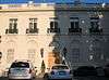
| 25 |
Lathrop House |
|
000000001973-04-11-0000April 11, 1973
(#73000448) |
627 Hamilton St.
37°29′17″N 122°13′48″W / 37.488056°N 122.23°W / 37.488056; -122.23 (Lathrop House) |
Redwood City |
|
| 26 |
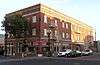
Martin Building |
|
000000001997-02-14-0000February 14, 1997
(#97000043) |
220 Linden Ave.[10]
37°39′18″N 122°24′32″W / 37.655°N 122.4089°W / 37.655; -122.4089 (Martin Building) |
South San Francisco |
Now known as the Metropolitan Hotel, a residential hotel
|
| 27 |
Menlo Park Railroad Station |
|
000000001974-10-01-0000October 1, 1974
(#74000556) |
1100 Merrill St.
37°27′16″N 122°10′51″W / 37.454444°N 122.180833°W / 37.454444; -122.180833 (Menlo Park Railroad Station) |
Menlo Park |
|
| 28 |
Methodist Episcopal Church at Half Moon Bay |
|
000000001980-11-10-0000November 10, 1980
(#80000854) |
777 Miramontes St.
37°27′46″N 122°25′37″W / 37.462778°N 122.426944°W / 37.462778; -122.426944 (Methodist Episcopal Church at Half Moon Bay) |
Half Moon Bay |
|
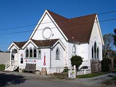
| 29 |
Methodist Episcopal Church of Pescadero |
|
000000001982-03-10-0000March 10, 1982
(#82002260) |
108 San Gregorio St.
37°15′05″N 122°22′54″W / 37.251389°N 122.381667°W / 37.251389; -122.381667 (Methodist Episcopal Church of Pescadero) |
Pescadero |
|
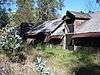
| 30 |
Robert Mills Dairy Barn |
|
000000001990-02-15-0000February 15, 1990
(#90000120) |
Higgins Purissima Rd.
37°27′20″N 122°23′18″W / 37.455556°N 122.388333°W / 37.455556; -122.388333 (Robert Mills Dairy Barn) |
Half Moon Bay |
|
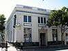
| 31 |
National Bank of San Mateo |
|
000000001997-04-24-0000April 24, 1997
(#97000331) |
164 S. B St.
37°34′00″N 122°19′20″W / 37.566667°N 122.322222°W / 37.566667; -122.322222 (National Bank of San Mateo) |
San Mateo |
|
| 32 |
New Sequoia Theater Building |
|
000000001994-05-05-0000May 5, 1994
(#94000431) |
2211-2235 Broadway
37°29′11″N 122°13′47″W / 37.486389°N 122.229722°W / 37.486389; -122.229722 (New Sequoia Theater Building) |
Redwood City |
|
| 33 |
Newhall Estate |
|
000000002007-04-13-0000April 13, 2007
(#07000308) |
1761 Manor Dr.
37°34′42″N 122°21′39″W / 37.578333°N 122.360833°W / 37.578333; -122.360833 (Newhall Estate) |
Hillsborough |
|
| 34 |
John Offerman House |
Upload image |
000000002015-10-05-0000October 5, 2015
(#15000682) |
1018 Main St.
37°29′02″N 122°13′34″W / 37.4838°N 122.2261°W / 37.4838; -122.2261 (John Offerman House) |
Redwood City |
|
| 35 |
Our Lady of the Wayside |
|
000000001977-11-22-0000November 22, 1977
(#77000338) |
930 Portola Rd.
37°23′02″N 122°13′58″W / 37.383889°N 122.232778°W / 37.383889; -122.232778 (Our Lady of the Wayside) |
Portola Valley |
|
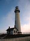
| 36 |
Pigeon Point Lighthouse |
|
000000001977-03-08-0000March 8, 1977
(#77000337) |
S of Pescadero at Pigeon Point off CA 1
37°10′54″N 122°23′38″W / 37.181667°N 122.393889°W / 37.181667; -122.393889 (Pigeon Point Lighthouse) |
Pescadero |
|
| 37 |
Pilarcitos Creek Bridge |
|
000000002014-04-07-0000April 7, 2014
(#14000110) |
Main St. across Pilarcitos Creek
37°27′58″N 122°25′44″W / 37.466045°N 122.428852°W / 37.466045; -122.428852 (Pilarcitos Creek Bridge) |
Half Moon Bay |
|
| 38 |
Point Montara Light Station |
|
000000001991-09-03-0000September 3, 1991
(#91001094) |
Jct. of 16th St. and CA 1
37°32′13″N 122°31′05″W / 37.536944°N 122.518056°W / 37.536944; -122.518056 (Point Montara Light Station) |
Montara |
|
| 39 |
POLARIS (research vessel) |
Upload image |
000000002015-03-24-0000March 24, 2015
(#15000100) |
597 Seaport Blvd.
37°30′25″N 122°12′43″W / 37.5069°N 122.2119°W / 37.5069; -122.2119 (POLARIS (research vessel)) |
Redwood City |
|
| 40 |
Portola Valley School |
|
000000001974-06-28-0000June 28, 1974
(#74000557) |
775 Portola Rd.
37°22′56″N 122°13′40″W / 37.382222°N 122.227778°W / 37.382222; -122.227778 (Portola Valley School) |
Portola Valley |
Later used as town hall.
|
| 41 |
Princeton Hotel |
|
000000001979-01-31-0000January 31, 1979
(#79000543) |
Capistrano Rd. and Prospect Way
37°30′18″N 122°29′08″W / 37.505°N 122.485556°W / 37.505; -122.485556 (Princeton Hotel) |
Princeton |
|
| 42 |
William C. Ralston House |
|
000000001966-11-15-0000November 15, 1966
(#66000234) |
College of Notre Dame campus
37°31′03″N 122°17′10″W / 37.5175°N 122.286111°W / 37.5175; -122.286111 (William C. Ralston House) |
Belmont |
|
| 43 |
Redwood City Historic Commercial Buildings |
|
000000001977-11-07-0000November 7, 1977
(#77000339) |
Broadway and Main Sts.
37°29′12″N 122°13′35″W / 37.486667°N 122.226389°W / 37.486667; -122.226389 (Redwood City Historic Commercial Buildings) |
Redwood City |
|
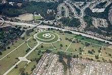
| 44 |
San Francisco Bay Discovery Site |
|
000000001968-05-23-0000May 23, 1968
(#68000022) |
Sweeney Ridge; 4 mi. west of San Bruno via Skyline Dr. and Sneath Lane
37°36′16″N 122°27′27″W / 37.604444°N 122.4575°W / 37.604444; -122.4575 (San Francisco Bay Discovery Site) |
San Bruno |
National Park Service brochure for Sweeney Ridge
|
| 45 |
San Gregorio House |
|
000000001977-05-06-0000May 6, 1977
(#77000341) |
Old Stage Rd.
37°19′35″N 122°23′09″W / 37.326389°N 122.385833°W / 37.326389; -122.385833 (San Gregorio House) |
San Gregorio |
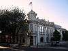
|
| 46 |
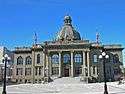
San Mateo County Courthouse |
|
000000001977-12-13-0000December 13, 1977
(#77000340) |
Broadway
37°29′13″N 122°13′47″W / 37.486944°N 122.229722°W / 37.486944; -122.229722 (San Mateo County Courthouse) |
Redwood City |
|
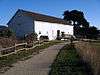
| 47 |
Sanchez Adobe Park |
|
000000001976-04-13-0000April 13, 1976
(#76000525) |
Linda Mar Blvd., 1 mi. E of CA 1
37°35′15″N 122°29′33″W / 37.5875°N 122.4925°W / 37.5875; -122.4925 (Sanchez Adobe Park) |
Pacifica |
|
| 48 |
Sequoia Union High School |
|
000000001995-04-07-0000April 7, 1995
(#95000389) |
1201 Brewster Ave.
37°29′04″N 122°14′09″W / 37.484444°N 122.235833°W / 37.484444; -122.235833 (Sequoia Union High School) |
Redwood City |
|
| 49 |
William Adam Simmons House |
|
000000001992-08-18-0000August 18, 1992
(#92000995) |
751 Kelly Ave.
37°27′49″N 122°25′38″W / 37.463611°N 122.427222°W / 37.463611; -122.427222 (William Adam Simmons House) |
Half Moon Bay |
|
| 50 |
South San Francisco Hillside Sign |
|
000000001996-07-11-0000July 11, 1996
(#96000761) |
Sign Hill Park, N of Park Way
37°39′49″N 122°25′08″W / 37.663611°N 122.418889°W / 37.663611; -122.418889 (South San Francisco Hillside Sign) |
South San Francisco |
|
| 51 |
Southern Pacific Depot |
|
000000001978-09-01-0000September 1, 1978
(#78000770) |
21 E. Millbrae Ave.
37°35′56″N 122°23′05″W / 37.598889°N 122.384722°W / 37.598889; -122.384722 (Southern Pacific Depot) |
Millbrae |
|
| 52 |
Southern Pacific Railroad Bayshore Roundhouse |
|
000000002010-03-26-0000March 26, 2010
(#10000113) |
Junction of Industrial Way and Bayshore Ave.
37°42′03″N 122°24′31″W / 37.700953°N 122.40855°W / 37.700953; -122.40855 (Southern Pacific Railroad Bayshore Roundhouse) |
Brisbane |
Steam railroad engine roundhouse built between 1907 and 1910
|
| 53 |
Southern Pacific Depot |
|
000000001984-09-20-0000September 20, 1984
(#84001191) |
559 El Camino Real
37°30′27″N 122°15′32″W / 37.5075°N 122.258889°W / 37.5075; -122.258889 (Southern Pacific Depot) |
San Carlos |
|
| 54 |
Union Cemetery |
|
000000001983-08-25-0000August 25, 1983
(#83001237) |
316 Woodside Rd.
37°28′26″N 122°13′23″W / 37.473889°N 122.223056°W / 37.473889; -122.223056 (Union Cemetery) |
Redwood City |
|
| 55 |
US Post Main Office-San Mateo |
|
000000001988-04-18-0000April 18, 1988
(#88000443) |
210 S. Ellsworth Ave.
37°34′00″N 122°19′24″W / 37.566667°N 122.323333°W / 37.566667; -122.323333 (US Post Main Office-San Mateo) |
San Mateo |
|
| 56 |
Amelia Vollers House |
|
000000002015-01-27-0000January 27, 2015
(#14001205) |
353 N. Claremont St.
37°34′27″N 122°19′46″W / 37.5741°N 122.3295°W / 37.5741; -122.3295 (Amelia Vollers House) |
San Mateo |
|
| 57 |
Watkins-Cartan House |
|
000000001978-03-30-0000March 30, 1978
(#78000768) |
98 Alejandra Ave.
37°27′13″N 122°11′49″W / 37.453611°N 122.196944°W / 37.453611; -122.196944 (Watkins-Cartan House) |
Atherton |
constructed around 1866 for Commodore James Watkins; originally listed as the Commodore James Watkins House; located at 25 Isabella Ave. when listed on the National Register; moved to 98 Alejandra Ave. in 1998[11]
|
| 58 |
William A. Whifler House |
Upload image |
000000002016-03-22-0000March 22, 2016
(#16000096) |
1544 Drake Ave.
37°35′14″N 122°22′44″W / 37.587278°N 122.378999°W / 37.587278; -122.378999 (William A. Whifler House) |
Burlingame |
|
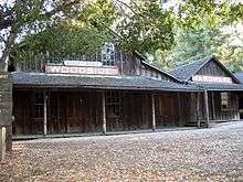
| 59 |
Woodside Store |
|
000000001985-07-18-0000July 18, 1985
(#85001563) |
471 Kings Mountain Rd.
37°25′49″N 122°16′34″W / 37.430278°N 122.276111°W / 37.430278; -122.276111 (Woodside Store) |
Woodside |
|
| 60 |
X-100 |
Upload image |
000000002016-06-20-0000June 20, 2016
(#16000381) |
1586 Lexington Ave.
37°31′30″N 122°21′12″W / 37.525085°N 122.353244°W / 37.525085; -122.353244 (X-100) |
San Mateo |
|
.jpg)


.JPG)