Colma, California
| Colma, California | ||
|---|---|---|
| Town | ||
| Town of Colma | ||
|
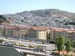
Colma, from the roof of the BART station parking garage. Portions of Daly City are in the background. | ||
| ||
| Motto: "It's great to be alive in Colma" | ||
 Location in San Mateo County and the state of California | ||
 Colma, California Location in the United States | ||
| Coordinates: 37°40′44″N 122°27′20″W / 37.67889°N 122.45556°WCoordinates: 37°40′44″N 122°27′20″W / 37.67889°N 122.45556°W | ||
| Country | United States | |
| State | California | |
| County | San Mateo | |
| Incorporated as "Lawndale" | August 5, 1924[1] | |
| Name changed to "Colma" | November 17, 1941 | |
| Government | ||
| • Mayor[2] | Helen Fisicaro | |
| • City Manager[3] | Sean Rabé | |
| Area[4] | ||
| • Total | 1.909 sq mi (4.945 km2) | |
| • Land | 1.909 sq mi (4.945 km2) | |
| • Water | 0 sq mi (0 km2) 0% | |
| Elevation | 121 ft (37 m) | |
| Population (2010) | ||
| • Total | 1,792 | |
| • Density | 940/sq mi (360/km2) | |
| United States Census Bureau | ||
| Time zone | PST (UTC-8) | |
| • Summer (DST) | PDT (UTC-7) | |
| ZIP code | 94014 | |
| Area code(s) | 650 | |
| FIPS code | 06-14736 | |
| GNIS feature ID | 1658303 | |
| Website | http://www.colma.ca.gov | |
Colma is a small incorporated town in San Mateo County, California, near the northern end of the San Francisco Peninsula in the San Francisco Bay Area. The population was 1,792 at the 2010 census. The town was founded as a necropolis in 1924.[5]
With most of Colma's land dedicated to cemeteries, the population of the dead outnumbers the living by over a thousand to one. This has led to Colma's being called "the City of the Silent" and has given rise to a humorous motto, now recorded on the city's website: "It's great to be alive in Colma."[5]
Etymology
The origin of the name Colma is widely disputed. Before 1872, Colma was designated as "Station" or "School House Station", the name of its post office in 1869. Currently, there seem to be seven possible sources of the town's being called Colma:[6]
- William T. Coleman, allegedly known as the "Lion of the Vigilantes" and a significant landowner in the area
- Thomas Coleman, a registered voter in the district in the 1870s
- A transfer name from Europe: Switzerland has a Colma; Alsace has a Colmar
- A re-spelling of an ancient Uralic word meaning death
- A literary origin from MacPherson's Songs of Selma, in one of the Ossianic fragments
- Native American languages:[7]
- "Kolma" means "moon" in one dialect of Costanoan, or Ohlone, who lived in the area; however, this name does not appear on any design ("diseño") of Indian rancherias at the time
- An undisclosed Native American word meaning "springs"
- A corruption of Colima,a Mexican place name meaning volcano, but also ancestors. [8]
Read more: http://www.nationsencyclopedia.com/mexico/Aguascalientes-M-xico/Colima.html#ixzz4Jhftp9Mp
History
The community of Colma was formed in the 19th century as a collection of homes and small businesses along El Camino Real and the adjacent railroad line. Several churches, including Holy Angels Catholic Church, were founded in these early years. The community founded its own fire district, which serves the unincorporated area of Colma north of the town limits, as well as the area that became a town in 1924.
Hienrich (Henry) von Kempf moved his wholesale nursery here in the early part of the 20th century, from the land where the Palace of Fine Arts currently sits (in what was known as "Cow Hollow") in San Francisco. The business was growing, and thus required more space for Hienrich's plants and trees. Hienrich then began petitioning to turn the Colma community into an agricultural township. He succeeded and became the town of Colma's first treasurer.
In the early 20th century, Colma was the site of many major boxing events. Famed middleweight world champion Stanley Ketchel held six bouts at the Mission Street Arena in Colma, including two world middleweight title bouts against Billy Papke and a world heavyweight title bout against Jack Johnson.[9]
San Francisco Cemetery relocations
Colma became the site for numerous cemeteries when San Francisco, the town's powerful neighbor to the north, passed an ordinance in 1900 outlawing the construction of any more cemeteries in the city (mainly because of increased property values making the cost of using land for cemeteries prohibitive), and then passed another ordinance in 1912 evicting all existing cemeteries from city limits. (A similar scenario prevails in New York City's borough of Manhattan, where there are only two active cemeteries, both in the recently gentrified Lower East Side, with marble-lined, underground vaults that pass Department of Health codes.[10]) The relocation of cemeteries from San Francisco to Colma is the subject of A Second Final Rest: The History of San Francisco's Lost Cemeteries (2005), a documentary by Trina Lopez.
The Town of Lawndale was incorporated in 1924, primarily at the behest of the cemetery owners with the cooperation of the handful of residents who lived closest to the cemeteries. The residential and business areas immediately to the north continued to be known as Colma. Because another city in Los Angeles County named Lawndale already existed, the post office retained the Colma designation, and the town changed its name back to Colma in 1941.
Originally, Colma's residents were primarily employed in occupations related to the many cemeteries in the town. Since the 1980s, however, Colma has become more diversified, and a variety of retail businesses and automobile dealerships has brought more sales tax revenue to the town government.[5]
Notable interments
Many, if not most of the well known people who died in San Francisco since the first cemeteries opened here have been buried in Colma, with an additional large number of such burials in Oakland's Mountain View Cemetery. Some notable people interred in Colma include:
- Cypress Lawn Memorial Park
- William Henry Crocker, business magnate
- Charles De Young, San Francisco Chronicle founder
- Phineas Gage, famous 19th-century medical curiosity
- William Randolph Hearst, newspaper tycoon
- John McLaren, horticulturist
- Turk Murphy, jazz musician and bandleader
- Hills of Eternity and Home of Peace (side-by-side cemeteries)
- Wyatt Earp is buried next to his wife, Josephine Marcus Earp[5][11]
- Julie Rosewald, America's first female cantor[12]
- Levi Strauss, denim trouser pioneer
- Alice B. Toklas is not buried in Colma, though there is a large Toklas tombstone for her and markers there for some of her relatives[11]
- Holy Cross Cemetery
- Joseph Alioto, San Francisco Mayor
- Pat Brown, 32nd governor of California
- Patrick and Terence Casey, the San Francisco brothers team of pulp writers
- Frank "the Crow" Crosetti, New York Yankees shortstop
- Joe DiMaggio, baseball player [5]
- Abigail Folger, coffee heiress and Manson murder victim
- A.P. Giannini, Bank of America founder
- Vince Guaraldi, jazz musician
- James D. Phelan, senator
- Woodlawn Cemetery
- Henry Miller, California cattle rancher
- Joshua Abraham "Emperor" Norton, a late 1800s San Francisco celebrity known as "Emperor of these United States and Protector of Mexico"
- José Sarria, LGBT political activist who styled himself "The Widow Norton" in reference to Norton[11]
Geography and geology
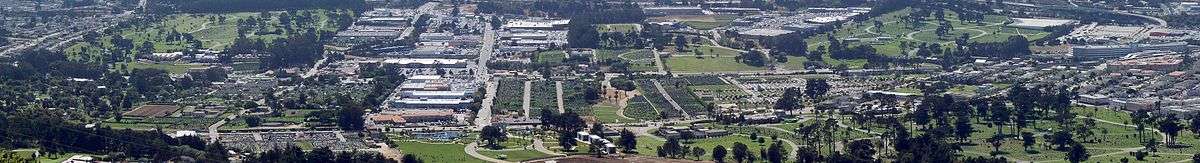
According to the United States Census Bureau, the town has a total area of 1.9 sq mi (4.9 km2), all land. The town's 17 cemeteries comprise approximately 73% of the town's land area.
Colma is situated on the San Francisco Peninsula at the highest point of the Merced Valley, a gap between San Bruno Mountain and the northernmost foothills of the Santa Cruz Mountain Range.[13][14] The foothills and eastern flanks of the range are composed largely of poorly consolidated Pliocene-Quaternary freshwater and shallow marine sediments that include the Colma and Merced Formations, recent slope wash, ravine fill, colluvium, and alluvium. These surficial deposits unconformably overlay the much older Jurassic to Cretaceous-aged Franciscan Assemblage. An old landfill about 135 deep existed at the site developed by the 260,000 sq ft (24,000 m2) mixed use Metro Center.[15]
Colma Creek flows through the city as it makes its way from San Bruno Mountain to San Francisco Bay.
Transportation
Colma (Bart Station) serves the city as part of the BART system. The station is served by the Pittsburg/Bay Point–SFO/Millbrae and Richmond–Millbrae lines, and served as a terminal station from 1996 to 2003, prior to the SFO/Millbrae extension. Since the extension, the next station to the south has been South San Francisco Station, located 0.1 miles (0.16 km) from Colma's southern city limits and Holy Cross Cemetery.
SamTrans provides bus service to the city.
Planning and environmental factors
When the Metro Center was developed, the Environmental Impact Report required a methane gas collection system to be constructed in order to collect off-gassing from the prior municipal solid waste disposal site at that location.
Demographics
| Historical population | |||
|---|---|---|---|
| Census | Pop. | %± | |
| 1880 | 188 | — | |
| 1930 | 369 | — | |
| 1940 | 354 | −4.1% | |
| 1950 | 297 | −16.1% | |
| 1960 | 500 | 68.4% | |
| 1970 | 537 | 7.4% | |
| 1980 | 395 | −26.4% | |
| 1990 | 1,103 | 179.2% | |
| 2000 | 1,191 | 8.0% | |
| 2010 | 1,792 | 50.5% | |
| Est. 2015 | 1,520 | [16] | −15.2% |
Informally, as of December 2006, Colma had "1,500 aboveground residents ... and 1.5 million underground".[5]
2010
The 2010 United States Census[18] reported that Colma had a population of 1,792. The population density was 938.6 people per square mile (362.4/km²). The racial makeup of Colma was 620 (34.6%) White, 59 (3.3%) African American, 7 (0.4%) Native American, 619 (34.5%) Asian, 9 (0.5%) Pacific Islander, 366 (20.4%) from other races, and 112 (6.3%) from two or more races. Hispanic or Latino of any race were 708 persons (39.5%).
The Census reported that 1,763 people (98.4% of the population) lived in households, 0 (0%) lived in non-institutionalized group quarters, and 29 (1.6%) were institutionalized.
There were 564 households, out of which 217 (38.5%) had children under the age of 18 living in them, 271 (48.0%) were opposite-sex married couples living together, 110 (19.5%) had a female householder with no husband present, 42 (7.4%) had a male householder with no wife present. There were 44 (7.8%) unmarried opposite-sex partnerships, and 8 (1.4%) same-sex married couples or partnerships. 91 households (16.1%) were made up of individuals and 31 (5.5%) had someone living alone who was 65 years of age or older. The average household size was 3.13. There were 423 families (75.0% of all households); the average family size was 3.45.
The population was spread out with 390 people (21.8%) under the age of 18, 178 people (9.9%) aged 18 to 24, 532 people (29.7%) aged 25 to 44, 488 people (27.2%) aged 45 to 64, and 204 people (11.4%) who were 65 years of age or older. The median age was 36.4 years. For every 100 females there were 92.7 males. For every 100 females age 18 and over, there were 88.9 males.
There were 586 housing units at an average density of 306.9 per square mile (118.5/km²), of which 224 (39.7%) were owner-occupied, and 340 (60.3%) were occupied by renters. The homeowner vacancy rate was 1.7%; the rental vacancy rate was 2.3%. 738 people (41.2% of the population) lived in owner-occupied housing units and 1,025 people (57.2%) lived in rental housing units.
2000
In the census[19] of 2000, there were 1,191 people, 329 households, and 245 families residing in the town. The population density was 624.6 people per square mile (240.8/km2). There were 342 housing units at an average density of 179.4 per square mile (69.1/km2).
There were 329 households out of which 36.2% had children under the age of 18 living with them, 57.1% were married couples living together, 11.9% had a female householder with no husband present, and 25.5% were non-families. 17.3% of all households were made up of individuals and 10.0% had someone living alone who was 65 years of age or older. The average household size was 3.47 and the average family size was 3.92.
In the town the population was spread out with 24.7% under the age of 18, 8.9% from 18 to 24, 31.7% from 25 to 44, 19.1% from 45 to 64, and 15.5% who were 65 years of age or older. The median age was 37 years. For every 100 females there were 87.6 males. For every 100 females age 18 and over, there were 86.9 males.
The median income for a household in the town was US$58,750, and the median income for a family was US$60,556. Males had a median income of US$32,059 versus US$29,934 for females. The per capita income for the town was US$20,241. About 3.4% of families and 5.2% of the population were below the poverty line, including 4.8% of those under age 18 and 3.7% of those age 65 or over.
In art, entertainment, and media
- A Second Final Rest: The History of San Francisco's Lost Cemeteries (2005), by Trina Lopez, documents the relocation of cemeteries from San Francisco to Colma
- Colma: The Musical (2007) is an American independent film that was shot on location in Colma and Daly City. The film has won several special jury prizes at local and international film festivals.[20][21]
- Colma: A Journey of Souls (2014), is a documentary film about the history of Colma, produced by Kingston Media.
- Colma (1998), the fourth studio album released by virtuoso guitarist Buckethead, makes reference to the town of Colma [22]
References
- ↑ "California Cities by Incorporation Date". California Association of Local Agency Formation Commissions. Archived from the original (Word) on November 3, 2014. Retrieved August 25, 2014.
- ↑ Town of Colma Elected Officials. Colma.ca.gov. Retrieved on 2013-07-21.
- ↑ City Manager Home. Colma.ca.gov. Retrieved on 2013-07-21.
- ↑ U.S. Census Archived 2012-06-26 at WebCite
- 1 2 3 4 5 6 Carol Pogash (3 December 2006). "Colma, Calif., Is a Town of 2.2 Square Miles, Most of It 6 Feet Deep". The New York Times. Retrieved 13 February 2011.
- ↑ Gudde, Erwin G. California Place Names: The Origin and Etymology of Current Geographical Names (4th ed.). University of California Press. p. 86.
- ↑ "And Just How Are Things in Colma, Calif.? Awfully Quiet, Night and Day". New York Times. April 21, 1996. Retrieved July 21, 2013.
- ↑ http://www.nationsencyclopedia.com/mexico/Aguascalientes-M-xico/Colima.htmlOrigin of state name: From the Náhuatl (Amerindian) word collimaitl. Colli means either ancestors or volcano, and maitl means domain of.
- ↑ "Stanley Ketchel - Boxer". Boxrec.com. October 15, 1910. Retrieved July 21, 2013.
- ↑ Luo, Michael (2003-11-07). "One-of-a-Kind Real Estate Deal For Eternal Rest in Manhattan". The New York Times. Retrieved 2010-04-30.
- 1 2 3 Roisman, Jon (November 6, 2014). "Local Jewish history comes to life at cemetery walk". JWeekly.com.
- ↑ jon roisman. "Local Jewish history comes to life at cemetery walk". Retrieved 7 November 2014.
- ↑ Colma Cardroom Project, Environmental Impact Report, Environmental Science Associates, prepared for the city of Colma (1993); IV.B. "Geology and Soils".
- ↑ About the Mountain: Topography and Climate, San Bruno Mountain Watch (nd).
- ↑ M.Papineau, B.George, J.Buxton et al., Environmental Impact Report for the Metro Center, Colma, California, Earth Metrics report 10062, prepared for the city of Colma and the California State Clearinghouse (1989)
- ↑ "Annual Estimates of the Resident Population for Incorporated Places: April 1, 2010 to July 1, 2015". Retrieved July 2, 2016.
- ↑ "Census of Population and Housing". Census.gov. Archived from the original on May 11, 2015. Retrieved June 4, 2015.
- ↑ "2010 Census Interactive Population Search: CA - Colma town". U.S. Census Bureau. Retrieved July 12, 2014.
- ↑ "American FactFinder". United States Census Bureau. Archived from the original on 2013-09-11. Retrieved 2008-01-31.
- ↑ Manohla Dargis (July 6, 2007). "Big Teenage Dreams, Small-Town Doldrums". The New York Times. Retrieved 2012-05-28.
- ↑ "Colma: The Musical". GreenRockSolid. July 5, 2007. Retrieved 2007-07-08.
- ↑ "Colma - Buckethead — Listen and discover music at Last.fm". www.last.fm. Retrieved 2016-02-15.
External links
Municipalities and communities of San Mateo County, California, United States | ||
|---|---|---|
| Cities and towns | 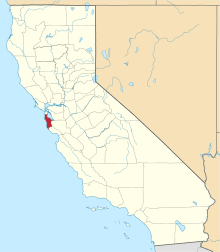 | |
| CDPs | ||
| Unincorporated communities | ||
| Ghost towns | ||
| Bodies of water |
|  |
|---|---|---|
| Counties | ||
| Major cities | ||
| Cities and towns 100k–250k | ||
| Cities and towns 50k–99k | ||
| Cities and towns 25k-50k | ||
| Cities and towns 10k–25k |
| |
| Sub-regions | ||