National Register of Historic Places listings in Wilkinson County, Mississippi
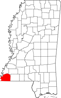
Location of Wilkinson County in Mississippi
This is a list of the National Register of Historic Places listings in Wilkinson County, Mississippi.
This is intended to be a complete list of the properties and districts on the National Register of Historic Places in Wilkinson County, Mississippi, United States. Latitude and longitude coordinates are provided for many National Register properties and districts; these locations may be seen together in a map.[1]
There are 16 properties and districts listed on the National Register in the county.
- This National Park Service list is complete through NPS recent listings posted December 16, 2016.[2]
Current listings
| [3] | Name on the Register[4] | Image | Date listed[5] | Location | City or town | Description |
|---|---|---|---|---|---|---|
| 1 | Anderson Mound | Upload image | (#86000921) |
Address Restricted |
Woodville | |
| 2 | Arbuthnot's Grocery and House | Upload image | (#16000284) |
8990 Pinckneyville Rd. 31°05′47″N 91°26′44″W / 31.096468°N 91.445445°W |
Woodville | |
| 3 | Branch Banking House | 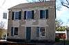 |
(#78001635) |
Bank St. 31°06′10″N 91°17′57″W / 31.102778°N 91.299167°W |
Woodville | Currently known as the Wilkinson County African-American Museum |
| 4 | Centreville Historic District | Upload image | (#92001091) |
Roughly bounded by Cherokee, Laurel, and St. Mary Sts. Coordinates missing |
Centreville | |
| 5 | Desert Plantation | Upload image | (#87000543) |
East of Pinckneyville-Woodville Rd. 31°01′37″N 91°28′33″W / 31.026944°N 91.475833°W |
Woodville | |
| 6 | Forest Home Plantation | Upload image | (#82003121) |
Southwest of Centreville 31°00′34″N 91°11′53″W / 31.009444°N 91.198056°W |
Centreville | |
| 7 | Fort Adams Site | Upload image | (#74001067) |
South of Fort Adams 31°04′46″N 91°32′51″W / 31.079444°N 91.5475°W |
Fort Adams | |
| 8 | Hampton Hall | Upload image | (#80002307) |
U.S. Highway 61 31°05′40″N 91°17′30″W / 31.094444°N 91.291667°W |
Woodville | |
| 9 | Holly Grove | Upload image | (#88002037) |
Mississippi Highway 33, 4 miles south of Mississippi Highway 24 31°02′23″N 91°06′09″W / 31.039722°N 91.1025°W |
Centreville | |
| 10 | Office and Banking House of West Feliciana Railroad | Upload image | (#77000798) |
Depot St. 31°06′10″N 91°17′54″W / 31.102778°N 91.298333°W |
Woodville | |
| 11 | Pleasant Hill | Upload image | (#82000582) |
East of Woodville on Mississippi Highway 24 31°05′27″N 91°15′35″W / 31.090833°N 91.259722°W |
Woodville | |
| 12 | Rosemont |  |
(#74001068) |
East of Woodville on Mississippi Highway 24 31°06′02″N 91°16′31″W / 31.100556°N 91.275278°W |
Woodville | Also known as Poplar Grove or the Hale House |
| 13 | Salisbury Plantation | Upload image | (#83000970) |
Off Woodville Rd. 31°03′28″N 91°26′39″W / 31.057778°N 91.444167°W |
Woodville | |
| 14 | Smith Creek Site | Upload image | (#78001634) |
Address Restricted |
Fort Adams | |
| 15 | Tansy Island Hunting Club Camp Site and Clubhouse | Upload image | (#95000179) |
Tansy Island Rd., off of Dolosoro Loop 31°16′02″N 91°23′31″W / 31.267222°N 91.391944°W |
Woodville | |
| 16 | Woodville Historic District |  |
(#82003122) |
Roughly bounded by Prentiss, 2nd, College, Siglo, and Water Sts.; also 546 Depot St. and 559 3rd St.; also roughly along Depot, 1st West, Main, 2nd South, Sligo, 3rd South, and Water Sts.; also roughly bounded by the Old Prentiss Highway, U.S. Route 61, and the city limits 31°06′07″N 91°17′56″W / 31.101944°N 91.298889°W |
Woodville | Boundaries after the first semicolon represent boundary increases of October 21, 1993, May 20, 1999, and October 19, 2001 |
See also
| Wikimedia Commons has media related to National Register of Historic Places in Wilkinson County, Mississippi. |
- List of National Historic Landmarks in Mississippi
- National Register of Historic Places listings in Mississippi
References
- ↑ The latitude and longitude information provided in this table was derived originally from the National Register Information System, which has been found to be fairly accurate for about 99% of listings. For about 1% of NRIS original coordinates, experience has shown that one or both coordinates are typos or otherwise extremely far off; some corrections may have been made. A more subtle problem causes many locations to be off by up to 150 yards, depending on location in the country: most NRIS coordinates were derived from tracing out latitude and longitudes off of USGS topographical quadrant maps created under the North American Datum of 1927, which differs from the current, highly accurate WGS84 GPS system used by most on-line maps. Chicago is about right, but NRIS longitudes in Washington are higher by about 4.5 seconds, and are lower by about 2.0 seconds in Maine. Latitudes differ by about 1.0 second in Florida. Some locations in this table may have been corrected to current GPS standards.
- ↑ "National Register of Historic Places: Weekly List Actions". National Park Service, United States Department of the Interior. Retrieved on December 16, 2016.
- ↑ Numbers represent an ordering by significant words. Various colorings, defined here, differentiate National Historic Landmarks and historic districts from other NRHP buildings, structures, sites or objects.
- ↑ National Park Service (2009-03-13). "National Register Information System". National Register of Historic Places. National Park Service.
- ↑ The eight-digit number below each date is the number assigned to each location in the National Register Information System database, which can be viewed by clicking the number.
| Topics | |
|---|---|
| Lists by states |
|
| Lists by insular areas | |
| Lists by associated states | |
| Other areas | |
| |
Municipalities and communities of Wilkinson County, Mississippi, United States | ||
|---|---|---|
| Towns | | |
| Communities | ||
| Ghost towns | ||
| Footnotes | ‡This populated place also has portions in an adjacent county or counties | |
This article is issued from Wikipedia - version of the 6/4/2016. The text is available under the Creative Commons Attribution/Share Alike but additional terms may apply for the media files.