Wilkinson County, Mississippi
| Wilkinson County, Mississippi | |
|---|---|
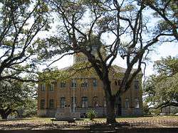 Wikinson County courthouse in Woodville | |
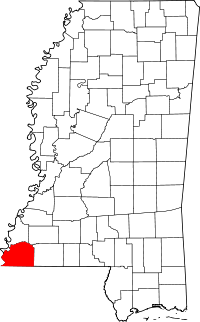 Location in the U.S. state of Mississippi | |
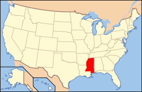 Mississippi's location in the U.S. | |
| Founded | 1802 |
| Named for | James Wilkinson |
| Seat | Woodville |
| Largest town | Centreville |
| Area | |
| • Total | 688 sq mi (1,782 km2) |
| • Land | 678 sq mi (1,756 km2) |
| • Water | 9.7 sq mi (25 km2), 1.4% |
| Population | |
| • (2010) | 9,878 |
| • Density | 15/sq mi (6/km²) |
| Congressional district | 3rd |
| Time zone | Central: UTC-6/-5 |
| Website |
www |
Wilkinson County is a county located in the U.S. state of Mississippi. As of the 2010 census, the population was 9,878.[1] Its county seat is Woodville.[2] The county is named for James Wilkinson, a Revolutionary War military leader and first governor of the Louisiana Territory after its acquisition by the United States in 1803.
History

In the nineteenth century, this county was developed by European-American settlers as cotton plantations along the Mississippi River, which forms the western border of the county. Much of the bottomlands and interior were undeveloped frontier until after the American Civil War. The intensive cultivation depended on the labor of numerous enslaved African Americans; in the early nineteenth century, more than a million were transported here from the Upper South in a major forced migration. The population of this county quickly became majority black as workers were brought in.
The West Feliciana Railroad was later built to help get the cotton commodity crop to market. Some planters got wealthy during the antebellum years and built fine mansions in the county seat of Woodville, Mississippi. After the Civil War, freedmen and planters negotiated new working arrangements, and sharecropping became widespread.
A long agricultural depression affected the economy. The peak of population in the county was reached in 1900, after which many blacks left in the Great Migration to the North and Midwest, to escape the racial segregation and disfranchisement suffered here since passage of the state's new constitution in 1890 and later Jim Crow laws.
In the early 20th century the boll weevil infestation destroyed much of the cotton crops, and mechanization caused a further loss of agricultural jobs. Timber has been harvested and processed as a new commodity crop. The population of the rural county has continued to decline. Towns have started to develop heritage tourism to attract more visitors.
Geography
According to the U.S. Census Bureau, the county has a total area of 688 square miles (1,780 km2), of which 678 square miles (1,760 km2) is land and 9.7 square miles (25 km2) (1.4%) is water.[3]
Major highways
Adjacent counties
- Adams County (north)
- Franklin County (northeast)
- Amite County (east)
- East Feliciana Parish, Louisiana (southeast)
- West Feliciana Parish, Louisiana (south)
- Concordia Parish, Louisiana (west)
National protected area
- Homochitto National Forest (part)
Demographics
| Historical population | |||
|---|---|---|---|
| Census | Pop. | %± | |
| 1810 | 5,068 | — | |
| 1820 | 9,718 | 91.8% | |
| 1830 | 11,686 | 20.3% | |
| 1840 | 14,193 | 21.5% | |
| 1850 | 16,914 | 19.2% | |
| 1860 | 15,933 | −5.8% | |
| 1870 | 12,705 | −20.3% | |
| 1880 | 17,815 | 40.2% | |
| 1890 | 17,592 | −1.3% | |
| 1900 | 21,453 | 21.9% | |
| 1910 | 18,075 | −15.7% | |
| 1920 | 15,319 | −15.2% | |
| 1930 | 13,957 | −8.9% | |
| 1940 | 15,955 | 14.3% | |
| 1950 | 14,116 | −11.5% | |
| 1960 | 13,235 | −6.2% | |
| 1970 | 11,099 | −16.1% | |
| 1980 | 10,021 | −9.7% | |
| 1990 | 9,678 | −3.4% | |
| 2000 | 10,312 | 6.6% | |
| 2010 | 9,878 | −4.2% | |
| Est. 2015 | 9,122 | [4] | −7.7% |
| U.S. Decennial Census[5] 1790-1960[6] 1900-1990[7] 1990-2000[8] 2010-2013[1] | |||
As of the 2010 United States Census, there were 9,878 people residing in the county. 70.8% were Black or African American, 28.7% White, 0.1% Native American, 0.1% of some other race and 0.3% of two or more races. 0.4% were Hispanic or Latino (of any race).
As of the census[9] of 2000, there were 10,312 people, 3,578 households, and 2,511 families residing in the county. The population density was 15 people per square mile (6/km²). There were 5,106 housing units at an average density of 8 per square mile (3/km²). The racial makeup of the county was 68.21% Black or African American, 31.22% White, 0.10% Native American, 0.03% Asian, 0.07% from other races, and 0.38% from two or more races. 0.44% of the population were Hispanic or Latino of any race.
There were 3,578 households out of which 32.90% had children under the age of 18 living with them, 40.40% were married couples living together, 24.50% had a female householder with no husband present, and 29.80% were non-families. 27.90% of all households were made up of individuals and 12.00% had someone living alone who was 65 years of age or older. The average household size was 2.59 and the average family size was 3.16.
In the county the population was spread out with 25.80% under the age of 18, 10.70% from 18 to 24, 29.00% from 25 to 44, 20.60% from 45 to 64, and 13.90% who were 65 years of age or older. The median age was 35 years. For every 100 females there were 108.00 males. For every 100 females age 18 and over, there were 106.60 males.
The median income for a household in the county was $18,929, and the median income for a family was $23,447. Males had a median income of $24,509 versus $16,088 for females. The per capita income for the county was $10,868. About 33.10% of families and 37.70% of the population were below the poverty line, including 48.90% of those under age 18 and 33.40% of those age 65 or over.
Wilkinson County has the sixth lowest per capita income in Mississippi and the 52nd lowest in the United States.
Education
Wilkinson County School District serves the county.
Wilkinson County Christian Academy is located near Woodville.
Communities
Towns
- Centreville (partly in Amite County)
- Crosby (partly in Amite County)
- Woodville (county seat)
Unincorporated communities
Ghost towns
Notable people
- Regina Barrow (born 1966), Louisiana state senator from Baton Rouge, Louisiana, since 2016; former state representative from 2005 to 2016; native of Wilkinson County[10]
- Anne Moody (born 1940), civil rights activist and author
- J. H. Netterville (1879-1943), plantation manager in Tensas Parish, Louisiana, native of Wilkinson County
- Edward Grady Partin (1924–1990), Teamsters Union business agent in Baton Rouge, native of Woodville
See also
References
- 1 2 "State & County QuickFacts". United States Census Bureau. Retrieved September 7, 2013.
- ↑ "Find a County". National Association of Counties. Retrieved 2011-06-07.
- ↑ "2010 Census Gazetteer Files". United States Census Bureau. August 22, 2012. Retrieved November 8, 2014.
- ↑ "County Totals Dataset: Population, Population Change and Estimated Components of Population Change: April 1, 2010 to July 1, 2015". Retrieved July 2, 2016.
- ↑ "U.S. Decennial Census". United States Census Bureau. Retrieved November 8, 2014.
- ↑ "Historical Census Browser". University of Virginia Library. Retrieved November 8, 2014.
- ↑ "Population of Counties by Decennial Census: 1900 to 1990". United States Census Bureau. Retrieved November 8, 2014.
- ↑ "Census 2000 PHC-T-4. Ranking Tables for Counties: 1990 and 2000" (PDF). United States Census Bureau. Retrieved November 8, 2014.
- ↑ "American FactFinder". United States Census Bureau. Retrieved 2008-01-31.
- ↑ "Regina Ashford Barrow". Project Vote Smart. Retrieved April 27, 2015.
 |
Adams County | Franklin County | | |
| Concordia Parish, Louisiana | |
Amite County | ||
| ||||
| | ||||
| West Feliciana Parish, Louisiana | East Feliciana Parish, Louisiana |
Municipalities and communities of Wilkinson County, Mississippi, United States | ||
|---|---|---|
| Towns | | |
| Communities | ||
| Ghost towns | ||
| Footnotes | ‡This populated place also has portions in an adjacent county or counties | |
.svg.png)
Coordinates: 31°10′N 91°19′W / 31.16°N 91.32°W