Netu'a
| Netu'a | |
|---|---|
 | |
 Netu'a | |
| Coordinates: 33°3′53.24″N 35°19′21.97″E / 33.0647889°N 35.3227694°ECoordinates: 33°3′53.24″N 35°19′21.97″E / 33.0647889°N 35.3227694°E | |
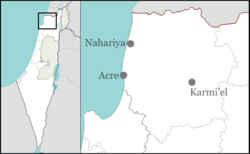
| District | Northern |
| Council | Ma'ale Yosef |
| Affiliation | Moshavim Movement |
| Founded | 1966 |
| Founded by | Moshavniks |
| Population (2015)[1] | 277 |
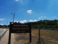
Netu'a (Hebrew: נְטוּעָה, lit. Planted) is an moshav in northern Israel. Located near the Lebanese border, it falls under the jurisdiction of Ma'ale Yosef Regional Council. In 2015 it had a population of 277.
History
The village was established in 1966 by residents of other local moshavim as part of a plan to encourage more Jewish settlement in the Galilee. It is founded on the land of the Arab village of Dayr al-Qassi,[2] which was depopulated in the 1948 Arab–Israeli War.
References
- ↑ "List of localities, in Alphabetical order" (PDF). Israel Central Bureau of Statistics. Retrieved 16 October 2016.
- ↑ Khalidi, Walid (1992), All That Remains, Washington D.C.: Institute for Palestine Studies, p. 13, ISBN 0-88728-224-5
This article is issued from Wikipedia - version of the 9/25/2016. The text is available under the Creative Commons Attribution/Share Alike but additional terms may apply for the media files.