New Blaine, Arkansas
| New Blaine, Arkansas | |
|---|---|
| Census-designated place | |
 New Blaine, Arkansas | |
| Coordinates: 35°17′22″N 93°25′13″W / 35.28944°N 93.42028°W | |
| Country | United States |
| State | Arkansas |
| County | Logan |
| Area[1] | |
| • Total | 1.954 sq mi (5.06 km2) |
| • Land | 1.631 sq mi (4.22 km2) |
| • Water | 0.323 sq mi (0.84 km2) |
| Elevation | 348 ft (106 m) |
| Population (2010)[2] | |
| • Total | 174 |
| • Density | 89/sq mi (34/km2) |
| Time zone | Central (CST) (UTC-6) |
| • Summer (DST) | CDT (UTC-5) |
| Area code(s) | 479 |
| GNIS feature ID | 58088[3] |
New Blaine is an unincorporated census-designated place in Logan County, Arkansas, United States. As of the 2010 census, its population is 174.[2] It is the location of (or is the nearest community to) Anhalt Barn, which is on County Road 68, Old Arkansas Highway 22, which is part of AR 197, AR 197 Loop, and Rainwater Loop, Elizabeth Hall, off AR 22, Farmer's State Bank, at 100 Seallars St., Freeborn T. Laster House, at 494 AR 197, Main Street Bridge, located at 2002 Sellers St. at Silver Smith Branch, New Blaine School, located at the junction of AR 22 and Spring Rd., and Troy Lasater Service Station located on the AR 197 Loop. All eight of these places are listed on the National Register of Historic Places.[4]
References
- ↑ "US Gazetteer files: 2010, 2000, and 1990". United States Census Bureau. 2011-02-12. Retrieved 2011-04-23.
- 1 2 "American FactFinder". U.S. Census Bureau. Retrieved 6 May 2011.
- ↑ U.S. Geological Survey Geographic Names Information System: New Blaine, Arkansas
- ↑ National Park Service (2009-03-13). "National Register Information System". National Register of Historic Places. National Park Service.
Municipalities and communities of Logan County, Arkansas, United States | ||
|---|---|---|
| Cities | 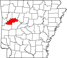 | |
| Towns | ||
| CDP | ||
| Unincorporated communities | ||
Coordinates: 35°17′22″N 93°25′13″W / 35.28944°N 93.42028°W