New York State Route 362
| ||||
|---|---|---|---|---|
|
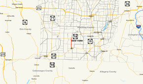
Map of Wyoming County in western New York with NY 362 highlighted in red | ||||
| Route information | ||||
| Maintained by NYSDOT | ||||
| Length: | 3.68 mi[1] (5.92 km) | |||
| Existed: | 1930[2] – present | |||
| Major junctions | ||||
| South end: |
| |||
| North end: |
| |||
| Location | ||||
| Counties: | Wyoming | |||
| Highway system | ||||
| ||||

New York State Route 362 (NY 362) is a state highway located entirely in Wyoming County, New York, in the United States. It runs north–south for 3.68 miles (5.92 km) between an intersection with NY 39 in the town of Eagle and a junction with NY 78 in the town of Wethersfield. The two-lane route begins in the hamlet of Bliss, and heads across gradually less developed areas as it heads north from the community. NY 362 was assigned to its current routing as part of the 1930 renumbering of state highways in New York.
Route description

NY 362 begins at an intersection with NY 39 in the hamlet of Bliss, located within the town of Eagle. The route heads north through the community as a two-lane road, traversing several residential blocks ahead of a junction with Main Street (County Route 58). Past this junction, NY 362 turns northwest and heads under an abandoned railroad overpass as it leaves Bliss for less developed areas of the town of Eagle. Outside of Bliss, the highway gradually turns to the north, serving a handful of scattered residences located in otherwise open and rolling terrain in the northern part of the town. NY 362 eventually crosses into the town of Wethersfield, where the homes gradually give way to large cultivated fields ahead of the route's end at a rural junction with NY 78.[3]
History
On April 27, 1911, the state of New York awarded a contract to rebuild all of what is now NY 362. The project cost $44,785 to complete (equivalent to $1.1 million in 2016), and the reconstructed road was added to the state highway system on January 24, 1912, as unsigned State Highway 893 (SH 893).[4][5] In the 1930 renumbering of state highways in New York, hundreds of state-maintained highways were given posted route numbers for the first time.[6] One of these was SH 893, which was designated NY 362.[2] The alignment of the route has not been changed since that time.[3]
Major intersections
The entire route is in Wyoming County.
| Location | mi[1] | km | Destinations | Notes | |
|---|---|---|---|---|---|
| Eagle | 0.00 | 0.00 | Hamlet of Bliss | ||
| Wethersfield | 3.68 | 5.92 | |||
| 1.000 mi = 1.609 km; 1.000 km = 0.621 mi | |||||
See also
.svg.png) New York Roads portal
New York Roads portal
References
- 1 2 "2008 Traffic Volume Report for New York State" (PDF). New York State Department of Transportation. June 16, 2009. p. 219. Retrieved February 1, 2010.
- 1 2 Road Map of New York (Map). Cartography by General Drafting. Standard Oil Company of New York. 1930.
- 1 2 Microsoft; Nokia (January 4, 2013). "overview map of NY 362" (Map). Bing Maps. Microsoft. Retrieved January 4, 2013.
- ↑ State of New York Commission of Highways (1922). Tables Giving Detailed Information and Present Status of All State, County and Federal Aid Highways. Albany, NY: J. B. Lyon Company. p. 46. Retrieved January 18, 2013.
- ↑ Federal Reserve Bank of Minneapolis Community Development Project. "Consumer Price Index (estimate) 1800–". Federal Reserve Bank of Minneapolis. Retrieved October 21, 2016.
- ↑ Dickinson, Leon A. (January 12, 1930). "New Signs for State Highways". The New York Times. p. 136.
External links
| Wikimedia Commons has media related to New York State Route 362. |
- New York State Route 362 at New York Routes • New York State Highway Termini