New York State Route 397
| ||||
|---|---|---|---|---|
|
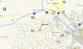
Map of Albany County in eastern New York with NY 397 highlighted in red | ||||
| Route information | ||||
| Maintained by NYSDOT | ||||
| Length: | 3.09 mi[1] (4.97 km) | |||
| Existed: | 1930[2] – present | |||
| Major junctions | ||||
| South end: |
| |||
| North end: |
| |||
| Location | ||||
| Counties: | Albany | |||
| Highway system | ||||
| ||||

New York State Route 397 (NY 397) is a short state highway in New York, running from the village of Altamont to the hamlet of Dunnsville within the town of Guilderland, in Albany County. NY 397 is a two-lane highway its entire length.
Route description

NY 397 begins at an intersection with NY 146 (Western Avenue) and Maple Avenue (which connects to County Route 253) in the village of Altamont. NY 397 proceeds east along Western Avenue through downtown Altamont, a two-lane residential street that turns north at a junction with the Schoharie Plank Road. Retaining the Western Avenue name, NY 397 passes west of Bozenkill Park and crosses into the town of Guilderland. At the junction with Bozenkill Road, the route turns northeast, crossing over a small creek, where it changes names to Dunnsville Road. After the turn, NY 397 begins winding northeast through a small rural section of Albany County.[3]
Running along the northwestern side of the Orchard Green Golf Course, the route passes the entrance near the junction with Becker Road. At this junction, NY 397 turns northward, winding past multiple homes before reaching the hamlet of Dunnsville. In Dunnsville, NY 397 reaches a junction with US 20 (Western Avenue), marking the northern end of NY 397. Dunnsville Road continues north towards the Schenectady County line and NY 406.[3]
History
A two-block portion of NY 397 through the village of Altamont follows a portion of the former Albany and Schoharie Plank Road, which represents a majority of current-day NY 146 and some of NY 443. The plank road, which was incorporated in 1849 and abandoned in 1866,[4] ran from the village of Schoharie and to meet with the First Great Western Turnpike in the town of Guilderland.
NY 397 was assigned to its current alignment as part of the 1930 renumbering of state highways in New York and has not had any major changes since.[2]
Major intersections
The entire route is in Albany County.
| Location | mi[1] | km | Destinations | Notes | |
|---|---|---|---|---|---|
| Altamont | 0.00 | 0.00 | |||
| Guilderland | 3.09 | 4.97 | Hamlet of Dunnsville | ||
| 1.000 mi = 1.609 km; 1.000 km = 0.621 mi | |||||
See also
.svg.png) New York Roads portal
New York Roads portal
References
- 1 2 "2008 Traffic Volume Report for New York State" (PDF). New York State Department of Transportation. June 16, 2009. p. 227. Retrieved January 31, 2010.
- 1 2 Road Map of New York (Map). Cartography by General Drafting. Standard Oil Company of New York. 1930.
- 1 2 Microsoft; Nokia (November 26, 2012). "overview map of NY 397" (Map). Bing Maps. Microsoft. Retrieved November 26, 2012.
- ↑ Gregg, Mary (July 23, 1932). "Altamont High School Girl Chooses for Graduation Essay Topic, "The Old Schoharie and Albany Plank Road"". Knickerbocker Press. New York, New York. Retrieved November 28, 2012.
External links
| Wikimedia Commons has media related to New York State Route 397. |
- New York State Route 397 at New York Routes • New York State Highway Termini