Newalla, Oklahoma
| Newalla | |
|---|---|
| Unincorporated community | |
 Newalla  Newalla Location within the state of Oklahoma | |
| Coordinates: 35°24′18″N 97°9′46″W / 35.40500°N 97.16278°WCoordinates: 35°24′18″N 97°9′46″W / 35.40500°N 97.16278°W | |
| Country | United States |
| State | Oklahoma |
| County | Oklahoma |
| Elevation | 1,148 ft (350 m) |
| Time zone | Central (CST) (UTC-6) |
| • Summer (DST) | CDT (UTC-5) |
| Area code(s) | 405 |
Newalla is an unincorporated community in rural eastern Oklahoma County, Oklahoma, United States. Newalla is an adaption of the Osage name for the Canadian River. The post office was opened June 22, 1904.
Located just west of State Highway 270, north of Interstate 40, it is a part of the Oklahoma City Metropolitan Area.
Newalla, with a current elevation of 1,148 feet, is located within the Eastern bounds of Oklahoma County and appears on the Harrah, Oklahoma U.S. Geological Survey Map due to their close proximity. Newalla is a geographic area which spans unincorporated Oklahoma County and Unincorporated Cleveland County (also referred to as Little Axe). Portions of Newalla are also within Oklahoma City Limits. School districts that provide educational services to the community are the following: McLoud Public Schools, Harrah Public School, Choctaw Public Schools, Little Axe Public Schools, Mid-Del Public Schools, as well as Norman and Moore Public Schools. The estimated population of Newalla, Oklahoma is currently at 9,514.
Sources
Shirk, George H.; Oklahoma Place Names; University of Oklahoma Press; Norman, Oklahoma; 1987: ISBN 0-8061-2028-2 .
External links
Municipalities and communities of Oklahoma County, Oklahoma, United States | ||
|---|---|---|
| Cities | 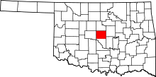 | |
| Towns | ||
| Unincorporated communities | ||
| Footnotes | ‡This populated place also has portions in an adjacent county or counties | |