Newburgh Lock and Dam
| Newburgh Lock and Dam | |
|---|---|
 | |
| Location | Indiana/Kentucky border |
| Coordinates | 37°55′46″N 87°22′24″W / 37.9294°N 87.3734°WCoordinates: 37°55′46″N 87°22′24″W / 37.9294°N 87.3734°W |
| Construction began | June 1966 |
| Opening date | 1975 |
| Operator(s) |
|
| Dam and spillways | |
| Type of dam | Concrete fixed weir with 9 Tainter gates |
| Impounds | Ohio River |
| Length | 2,275 feet |
| Reservoir | |
| Normal elevation | 358 feet above sealevel |
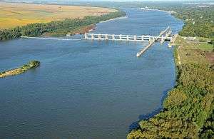
Newburgh Lock and Dam is the 16th Lock and dam on the Ohio River, located 776 miles down stream of Pittsburgh. There are 2 locks, one for commercial barge traffic that's 1,200 feet long by 110 feet wide, and the auxiliary lock is 600 feet long by 110 feet wide.[1]
See also
References
External links
- U.S. Army Corps of Engineers, Pittsburgh District
- U.S. Army Corps of Engineers, Huntington District
- U.S. Army Corps of Engineers, Louisville District
This article is issued from Wikipedia - version of the 10/24/2016. The text is available under the Creative Commons Attribution/Share Alike but additional terms may apply for the media files.