Newell, California
| Newell | |
|---|---|
| census-designated place | |
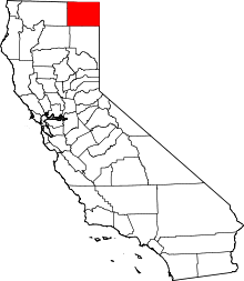
 Newell Location in California | |
| Coordinates: 41°53′18″N 121°22′20″W / 41.88833°N 121.37222°WCoordinates: 41°53′18″N 121°22′20″W / 41.88833°N 121.37222°W | |
| Country |
|
| State |
|
| County | Modoc |
| Area[1] | |
| • Total | 2.413 sq mi (6.249 km2) |
| • Land | 2.407 sq mi (6.234 km2) |
| • Water | 0.006 sq mi (0.015 km2) 0.24% |
| Elevation[2] | 4,042 ft (1,232 m) |
| Population (2010) | |
| • Total | 449 |
| • Density | 190/sq mi (72/km2) |
| Time zone | Pacific (PST) (UTC-8) |
| • Summer (DST) | PDT (UTC-7) |
| ZIP Code | 96134 |
| Area code(s) | 530 |
| GNIS feature IDs | 1659219; 2583091 |
| U.S. Geological Survey Geographic Names Information System: Newell, California; U.S. Geological Survey Geographic Names Information System: Newell, California | |
Newell is a census-designated place[3] in Modoc County, California in the United States.[2] It is located 50 miles (80 km) west-northwest of Alturas,[4] at an elevation of 4,042 feet (1,232 m).[2] The population was 449 at the 2010 census.
The community is located along State Route 139 south of Tulelake and about 10 miles (16 km) south of the Oregon border. It is less than 8 miles (13 km) south of Tulelake on the U.S. Geological Survey 7.5-minute quadrangle, Newell, California. The U.S. Geological Survey, National Geographic Names Database, calls its existence official with a feature ID of 1659219 and lists the coordinates of the community as 41°53′18″N 121°22′20″W / 41.88833°N 121.37222°W. The ZIP Code is 96134: a code shared with several other local towns. The community is inside area code 530.
History
The town was named in honor of Frederick Haynes Newell, director of the United States Reclamation Service.[4]
Geography
According to the United States Census Bureau, the CDP covers an area of 2.4 square miles (6.2 km2), 99.76% of it land, and 0.24% of it water.
Demographics
The 2010 United States Census[5] reported that Newell had a population of 449. The population density was 186.1 people per square mile (71.9/km²). The racial makeup of Newell was 199 (44.3%) White, 2 (0.4%) African American, 23 (5.1%) Native American, 1 (0.2%) Asian, 5 (1.1%) Pacific Islander, 193 (43.0%) from other races, and 26 (5.8%) from two or more races. Hispanic or Latino of any race were 271 persons (60.4%).
The Census reported that 449 people (100% of the population) lived in households, 0 (0%) lived in non-institutionalized group quarters, and 0 (0%) were institutionalized.
There were 136 households, out of which 69 (50.7%) had children under the age of 18 living in them, 74 (54.4%) were opposite-sex married couples living together, 24 (17.6%) had a female householder with no husband present, 8 (5.9%) had a male householder with no wife present. There were 10 (7.4%) unmarried opposite-sex partnerships, and 0 (0%) same-sex married couples or partnerships. 23 households (16.9%) were made up of individuals and 8 (5.9%) had someone living alone who was 65 years of age or older. The average household size was 3.30. There were 106 families (77.9% of all households); the average family size was 3.68.
The population was spread out with 167 people (37.2%) under the age of 18, 36 people (8.0%) aged 18 to 24, 116 people (25.8%) aged 25 to 44, 90 people (20.0%) aged 45 to 64, and 40 people (8.9%) who were 65 years of age or older. The median age was 29.4 years. For every 100 females there were 110.8 males. For every 100 females age 18 and over, there were 108.9 males.
There were 209 housing units at an average density of 86.6 per square mile (33.4/km²), of which 83 (61.0%) were owner-occupied, and 53 (39.0%) were occupied by renters. The homeowner vacancy rate was 1.2%; the rental vacancy rate was 8.6%. 259 people (57.7% of the population) lived in owner-occupied housing units and 190 people (42.3%) lived in rental housing units.
Politics
In the state legislature, Newell is in the 1st Senate District, represented by Republican Ted Gaines,[6] and the 1st Assembly District, represented by Republican Brian Dahle.[7]
Federally, Newell is in California's 1st congressional district, represented by Republican Doug LaMalfa.[8]
Landmarks
- There are many grain and horseradish storage facilities in or near Newell.
- Newell Elementary School, operated by Tulelake Basin Joint Unified School District, is a local landmark.
- Tule lake Municipal Airport, (FAA identifier: 081 or zero-eight-one) features a 3,500-foot (1,100 m) paved runway. The Common Traffic Advisory Frequency is 122.9 MHz.
- The site of the World War II U.S. Army facility named the Tule Lake War Relocation Center is near the north end of the community. The center was a prison camp for interned Japanese nationals, and U.S. citizens of Japanese ancestry, during a portion of the war.
- The Union Pacific Railroad Modoc Subdivision tracks run along the west side of town and parallel to SR139.
- Tulelake National Wildlife Refuge, a unit of Klamath National Wildlife Refuge, is northwest of the town. This is a U.S. Department of the Interior, U.S. Fish and Wildlife Service federal reservation.
See also
- Japanese American internment
- Lava Beds National Monument
- Tule Lake War Relocation Center
- Tionesta, California
- Tulelake, California
Sources
- Map: Lava Beds National Monument, California, 417-648/40240 (Washington, D.C.: Government Printing Office, 1997).
- U.S. Geological Survey, National Geographic Names Database.
- Map: U.S. Geological Survey, Newell, California, 7.5-minute Quadrangle, 1993.
- California Region Timetable: 14, (Modesto, California: Altamont Press, 2003).
References
- ↑ U.S. Census
- 1 2 3 U.S. Geological Survey Geographic Names Information System: Newell, California
- ↑ U.S. Geological Survey Geographic Names Information System: Newell, California
- 1 2 Durham, David L. (1998). California's Geographic Names: A Gazetteer of Historic and Modern Names of the State. Clovis, Calif.: Word Dancer Press. p. 404. ISBN 1-884995-14-4.
- ↑ "2010 Census Interactive Population Search: CA - Newell CDP". U.S. Census Bureau. Retrieved July 12, 2014.
- ↑ "Senators". State of California. Retrieved March 10, 2013.
- ↑ "Members Assembly". State of California. Retrieved March 2, 2013.
- ↑ "California's 1st Congressional District - Representatives & District Map". Civic Impulse, LLC. Retrieved March 2, 2013.