North Carolina Highway 186
| ||||
|---|---|---|---|---|
 | ||||
| Route information | ||||
| Maintained by NCDOT | ||||
| Length: | 23.4 mi[1] (37.7 km) | |||
| Existed: | 1975 – present | |||
| Major junctions | ||||
| West end: |
| |||
|
| ||||
| East end: |
| |||
| Location | ||||
| Counties: | Northampton | |||
| Highway system | ||||
| ||||

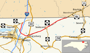
North Carolina Highway 186 (NC 186) is a primary state highway in the U.S. state of North Carolina. Entirely in Northampton County, it helps facilitate truck traffic parallel to Interstate 95 (I-95) and connect the communities of Seaboard and Margarettsville.
Route description
NC 186 is a two-lane rural highway that traverses 23.4 miles (37.7 km) from NC 48 near Gaston, to the Virginia state line near Margarettsville. The first 3.4 miles (5.5 km) parallel I-95 heading south before joining NC 46 towards Garysburg. Once in Garysburg, its concurrency with NC 46 ends and then briefly overlaps with US 301 before it heads in a northeasterly direction out of town. It then proceeds to connect Gumberry, Seaboard and Margarettsville, before crossing the state line into Virginia, becoming Virginia State Route 186 (SR 186), and heading towards Branchville and Boykins.
History
Established around 1975 as a renumbering of NC 195; the number change was to match with Virginia's SR 186, which was originally SR 195 before I-195 was established in Richmond, around 1970. It remained unchanged until May 21, 2013, when it was extended west and north from its former terminus at US 301 to NC 48. The justification for the extension was to help facilitate truck traffic and serve the Northampton Commerce Park and Enviva Industrial Facility, on what was SR 1200 (Lebanon Church Road and James Jones Road); it can also be used as an alternate route for I-95 in the event traffic has to be rerouted.[2]
North Carolina Highway 195
| |
|---|---|
| Location: | Garysburg-Virginia state line |
| Length: | 15.8 mi[3] (25.4 km) |
| Existed: | 1938–1975 |
North Carolina Highway 195 (NC 195) was established around 1938 as a renumbering of NC 305 between Garysburg to Seaboard, then continuing east on new primary routing into Virginia becoming SR 195. Around 1970, SR 195 was renumbered to SR 186; North Carolina reciprocated in 1975.
Junction list
The entire route is in Northampton County.
| Location | mi[1] | km | Destinations | Notes | |
|---|---|---|---|---|---|
| | 0.0 | 0.0 | |||
| | 3.4 | 5.5 | West end of NC 46 overlap | ||
| | 4.0 | 6.4 | Exit 176 (I-95) | ||
| Garysburg | 7.4 | 11.9 | South end of US 301 overlap and eastern terminus of NC 46 | ||
| 7.6 | 12.2 | North end of US 301 overlap | |||
| Seaboard | 14.6 | 23.5 | Northern terminus of NC 305 | ||
| | 23.4 | 37.7 | Virginia state line | ||
1.000 mi = 1.609 km; 1.000 km = 0.621 mi
| |||||
References
- 1 2 Google (June 13, 2013). "North Carolina Highway 186" (Map). Google Maps. Google. Retrieved June 13, 2013.
- ↑ "NC 186 Route Change (2013-05-21)" (PDF). North Carolina Department of Transportation. May 21, 2013. Retrieved June 13, 2013.
- ↑ Google (June 13, 2013). "North Carolina Highway 195" (Map). Google Maps. Google. Retrieved June 13, 2013.
External links
 Media related to North Carolina Highway 186 at Wikimedia Commons
- NCRoads.com: N.C. 186
- NCRoads.com: N.C. 195