North Carolina Highway 48
| ||||
|---|---|---|---|---|
 | ||||
| Route information | ||||
| Maintained by NCDOT | ||||
| Length: | 53.4 mi[1] (85.9 km) | |||
| Existed: | 1934 – present | |||
| Major junctions | ||||
| South end: |
| |||
| North end: |
| |||
| Location | ||||
| Counties: | Nash, Halifax, Northampton | |||
| Highway system | ||||
| ||||

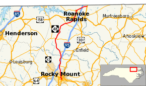
North Carolina Highway 48 (NC 48) is a state highway in the North Carolina Highway System that principally connects the cities of Rocky Mount and Roanoke Rapids. The route offers an alternative to US 301 and I-95.
Route description
The highway runs from the community of Pleasant Hill, just south of the North Carolina/Virginia border, south through the Hickory Crossroads area and into downtown Rocky Mount. Approximately half the route's length is shared with NC 4.
History
The second and current NC 48 was established in 1934 as a renumbering of NC 482, which traversed between NC 43, in Rocky Mount, and US 158, in Littleton.[2] In 1952, NC 48 was rerouted at Brinkleyville northeasterly on new primary routing to Roanoke Rapids, then replaced NC 47 through Gaston and Pleasant Hill; its former alignment became parts of NC 561, Old NC 48 (SR 1312) and NC 4.[3] Between 1963-1968, NC 48 was extended south, with NC 43, to US 301 Bus.[4] In 1998, NC 48, with NC 43, were rerouted on new connector on Peachtree Street.[5]
Major intersections
| County | Location | mi[1] | km | Destinations | Notes |
|---|---|---|---|---|---|
| Nash | Rocky Mount | 0.0 | 0.0 | One-way pair | |
| 0.1 | 0.16 | One-way pair | |||
| 0.2 | 0.32 | Southern end of NC 43 Bus. concurrency; NC 48 / NC 43 Bus. begins a one-way pair along Falls Road and Peachtree Street | |||
| 1.2– 1.4 | 1.9– 2.3 | Northern end of NC 43 Bus. concurrency; southern end of NC 43 concurrency | |||
| 1.9– 2.1 | 3.1– 3.4 | Interchange | |||
| 2.6 | 4.2 | Northern end of NC 43 concurrency | |||
| 8.7 | 14.0 | Exit 145 (I-95); southern end of NC 4 concurrency | |||
| | 13.7 | 22.0 | Western terminus of NC 33 | ||
| Halifax | Glenview | 16.5 | 26.6 | Western terminus of NC 481 | |
| Brinkleyville | 24.8 | 39.9 | Northern end of NC 4 concurrency | ||
| Gretna Green | 36.3 | 58.4 | |||
| Roanoke Rapids | 42.3 | 68.1 | |||
| 43.4 | 69.8 | Northern terminus of NC 125 | |||
| Northampton | Gaston | 46.7 | 75.2 | ||
| | 49.8 | 80.1 | Western terminus of NC 186 | ||
| | 50.3– 50.5 | 81.0– 81.3 | |||
| Pleasant Hill | 53.4 | 85.9 | |||
1.000 mi = 1.609 km; 1.000 km = 0.621 mi
| |||||
See also
- North Carolina Bicycle Route 4 - Concurrent with NC 48 from Gaston to Macon Price Road in Northampton County
References
- 1 2 Google (May 16, 2015). "North Carolina Highway 48" (Map). Google Maps. Google. Retrieved May 16, 2015.
- ↑ North Carolina Primary Highway System (PDF) (Map). Cartography by NCSHC. North Carolina State Highway Commission. 1940. Retrieved May 17, 2015.
- ↑ North Carolina County Road Survey 1953 (PDF) (Map). Cartography by NCHPWC / USPRA. North Carolina State Highway and Public Works Commission. 1953. Retrieved May 17, 2015.
- ↑ North Carolina County Road Survey 1968 (PDF) (Map). Cartography by NCSHC / USDOT / FHWA. North Carolina State Highway Commission – Planning and Research Department. 1968. Retrieved May 17, 2015.
- ↑ "Route Change (1998-07-31)" (PDF). North Carolina Department of Transportation. July 31, 1998. Retrieved May 17, 2015.
External links
-
 Media related to North Carolina Highway 48 at Wikimedia Commons
 - NCRoads.com: N.C. 48