North Fork Solomon River
| North Fork Solomon River | |
| Country | United States |
|---|---|
| State | Kansas |
| Source | |
| - location | Thomas County, Kansas |
| - elevation | 3,362 ft (1,025 m) |
| - coordinates | 39°16′52″N 101°16′55″W / 39.28111°N 101.28194°W [1] |
| Mouth | Waconda Lake |
| - location | Cawker City, Kansas |
| - elevation | 1,453 ft (443 m) |
| - coordinates | 39°28′23″N 98°26′00″W / 39.47306°N 98.43333°WCoordinates: 39°28′23″N 98°26′00″W / 39.47306°N 98.43333°W [1] |
| Length | 287 mi (462 km) |
| Discharge | for USGS 06872500 at Portis, KS[2] |
| - average | 121 cu ft/s (3 m3/s) |
| - max | 32,300 cu ft/s (915 m3/s) |
| - min | 0 cu ft/s (0 m3/s) |
| Watersheds | North Fork Solomon-Solomon-Smoky Hill-Kansas-Missouri-Mississippi |
| Reservoirs | Kirwin Reservoir, Waconda Lake |
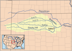 Map of the Smoky Hill drainage basin including the North Fork Solomon River | |
The North Fork Solomon River is a river in the central Great Plains of North America. Its entire 287-mile (462 km) length lies within the U.S. state of Kansas. It is a tributary of the Solomon River.[3]
Geography
The North Fork Solomon River originates in the High Plains of northwest Kansas. Its source lies in west-central Thomas County roughly 8 miles (13 km) southeast of Brewster, Kansas. From there, it flows generally east-northeast into the Smoky Hills region of north-central Kansas. Southeast of Phillipsburg, Kansas, the river joins its tributary Bow Creek to feed Kirwin Reservoir. From the reservoir's dam, the river flows east, then turns southeast near Gaylord, Kansas. Immediately south of Cawker City in northwestern Mitchell County, the North Fork joins the South Fork Solomon River to feed Waconda Lake.[3]
History
In 1955, the U.S. Bureau of Reclamation completed a dam on the river immediately south of Kirwin, Kansas for flood control, creating Kirwin Reservoir.[4]
See also
References
- 1 2 U.S. Geological Survey Geographic Names Information System: North Fork Solomon River
- ↑ "Water-Data Report 2012 - 06872500 North Fork Solomon River at Portis, KS" (PDF). U.S. Geological Survey. Retrieved 2015-10-20.
- 1 2 "2003-2004 Official Transportation Map" (PDF). Kansas Department of Transportation. Retrieved 2015-09-17.
- ↑ "Kirwin Unit". U.S. Bureau of Reclamation. Retrieved 2015-09-17.