Nugent Island
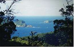 Nugent Island (in the trees) near Raoul Island. | |
 Map | |
| Geography | |
|---|---|
| Coordinates | 29°13′54″S 177°52′09″W / 29.23167°S 177.86917°W |
| Archipelago | Kermadec Islands |
| Administration | |
| Demographics | |
| Population | 0 |
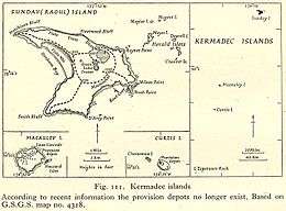
Nugent Island is the most northerly island in the Kermadec Islands and the most northerly part of New Zealand. It is one of the group to the north-east of Raoul Island. It is circular and approximately 100 metres (109 yd) across. It forms part of the Kermadec Islands Important Bird Area, identified as such by BirdLife International because it is an important site for nesting seabirds.[1]
See also
References
- ↑ BirdLife International. (2012). Important Bird Areas factsheet: Kermadec Islands. Downloaded from http://www.birdlife.org on 2012-02-03.
Coordinates: 29°13′54″S 177°52′09″W / 29.23167°S 177.86917°W
This article is issued from Wikipedia - version of the 11/12/2016. The text is available under the Creative Commons Attribution/Share Alike but additional terms may apply for the media files.