Nutt, New Mexico
| Nutt | |
|---|---|
| settlement | |
|
Nutt, New Mexico, January 2013, looking NE | |
 Nutt Location of Nutt in New Mexico | |
| Coordinates: 32°34′22″N 107°26′58″W / 32.57278°N 107.44944°WCoordinates: 32°34′22″N 107°26′58″W / 32.57278°N 107.44944°W | |
| Country | United States |
| State | New Mexico |
| County | Luna |
| Founded | 1881 |
| Elevation | 4,721 ft (1,439 m) |
| Population (2010)[1] | |
| • Total | 12 |
| Time zone | MST (UTC-7) |
| • Summer (DST) | MDT (UTC-6) |
| ZIP codes | 88030 |
| Area code(s) | 575 |
| GNIS feature ID | 898578 |
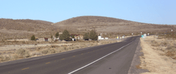
Nutt is an unincorporated community and ghost town in Luna County, southern New Mexico, in the American Southwest.[2] It is located nineteen miles southwest of Hatch on NM Route 26 at the intersection with NM Route 27.
History
Prior to the founding of the town, the area was the site of Lloyd's Ranch and Slocum's Ranch, and was subject to attacks by the Apache.[3]
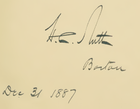
The town of Nutt was founded in 1881 as a station on the Atchison, Topeka and Santa Fe Railway and was named after Colonel Henry Clay Nutt who served on their board of directors, and was instrumental in getting enabling legislation through the New Mexico Territorial Legislature for the southern spur of the railway.[4][5] Wagon trains left Nutt for the mining communities in the Black Range until the Santa Fe ran a spur line up to Lake Valley in 1884.[6] Nutt had a post office from 1881 until 1884, and again from 1899 until 1939.[7][8]
Geography

Nutt is located on a rise between Los Uvas Valley to the east,[9] and the Macho Creek Valley to the west. The rise is actually a pass through the remnants of the Good Sight Mountains, the tallest of which, Nutt Mountain at 5,940 ft., is 2.5 miles north of Nutt.[5] Nutt Mountain is a volcanic plug composed of layered rhyolites, and has also been called Sunday Cone.[10] The soil in Nutt is composed of eroded tuffs, andesites, latites and rhyolites.
Demographics
For the 2010 census, Nutt was part of the United States Census Bureau's Deming North CCD, Tract 5.[11][12] In 2010, there were twelve people recorded for Nutt.[13]
Notes
- ↑ 11 in block 1007 "Census Block 000500-1-007 in Luna County, New Mexico". World Media Group using United States Census Bureau data. and 1 in block 1047 "Census Block 000500-1-047 in Luna County, New Mexico". World Media Group using United States Census Bureau data.
- ↑ "Geographic Names Information System: Feature Detail Report for: Nutt (ID:898578)". United States Geological Survey. 13 November 1980.
- ↑ Michno, Gregory (2003). Encyclopedia of Indian Wars: Western Battles and Skirmishes, 1850-1890. Missoula, Montana: Mountain Press Publishing. p. 328. ISBN 978-0-87842-468-9.
- ↑ Henry Clay Nutt received his rank of colonel in the Iowa militia. Staff (16 August 1892). "Obituary Notes". The New York Times. H.C. Nutt was president of the Atlantic and Pacific Railroad from 1881 to 1889. The biographical directory of the railway officials of America for 1887 (PDF). Chicago: The Railway Age Publishing Company. 1887. p. 235.
- 1 2 "Nutt Mountain: Climbing, Hiking & Mountaineering". Summit Post.
- ↑ The spur to Lake Valley was built by the New Mexican Railroad, which was a subsidiary of the Atchison, Topeka and Santa Fe Railway. Riskin, Marci L. (2005). The Train Stops Here: New Mexico's Railway Legacy. Albuquerque, New Mexico: University of New Mexico Press. p. 80. ISBN 978-0-8263-3307-0.
- ↑ Julyan, Robert Hixson (1996). The Place Names of New Mexico (second ed.). Albuquerque, New Mexico: University of New Mexico Press. p. 245. ISBN 978-0-8263-1689-9.
- ↑ Sherman, James E. & Sherman, Barbara H. (1975). Ghost Towns and Mining Camps of New Mexico. Norman, Oklahoma: University of Oklahoma Press. p. 162. ISBN 978-0-8061-1066-0.
- ↑ Hansen, Craig V.; et al. (1998). Nutt-Hockett Basin Hydrographic Survey Report (PDF). Santa Fe, New Mexico: Office of the State Engineer. p. v. Archived from the original (PDF) on 19 October 2003.
- ↑ Julyan, Robert Hixson (2006). The Mountains of New Mexico. Albuquerque, New Mexico: University of New Mexico Press. p. 237. ISBN 978-0-8263-3516-6.
- ↑ "Census Tract map: New Mexico, Luna County, Tract 5" (PDF). United States Census Bureau.
- ↑ As of 2010, the total population of Census Tract 000500 was 4,338. "Census Tract 000500 in Luna County, New Mexico Population and Races". World Media Group using United States Census Bureau data.
- ↑ In the 2010 census Nutt consisted of Census blocks 1005–1008, 1038–1042, 1045–1050, 1059, 1061, and 1062. Zero population was reported for all blocks, except 1007 with eleven people and 1047 with one person.
External links
- "Nutt – New Mexico Ghost Town". Atjeu Publishing.
Municipalities and communities of Luna County, New Mexico, United States | ||
|---|---|---|
| City |  | |
| Village | ||
| CDPs | ||
| Ghost towns | ||