Oakmulgee, Alabama
| Oakmulgee, Alabama | |
|---|---|
| Unincorporated community | |
 Oakmulgee, Alabama  Oakmulgee, Alabama | |
| Coordinates: 32°47′47″N 87°02′38″W / 32.79639°N 87.04389°WCoordinates: 32°47′47″N 87°02′38″W / 32.79639°N 87.04389°W | |
| Country | United States |
| State | Alabama |
| County | Perry |
| Elevation | 322 ft (98 m) |
| Time zone | Central (CST) (UTC-6) |
| • Summer (DST) | CDT (UTC-5) |
| Area code(s) | 334 |
| GNIS feature ID | 160283[1] |
Oakmulgee, also known as Oakmulga, or Ocmulgee, is an unincorporated community in Perry County, Alabama, United States. Oakmulgee is located on Alabama State Route 183, 21.5 miles (34.6 km) northeast of Marion. Oakmulgee lies entirely within the Oakmulgee District of the Talladega National Forest.
History
The name Oakmulgee is derived from the Hitchiti word ockmulgee, which means "bubbling water," with oki meaning "water" and mulgi meaning "boiling".[2] A post office operated under the name Ocmulgee from 1850 to 1853, under the name Oakmulga from 1857 to 1866, and under the name Oakmulgee from 1876 to 1913.[3] At one point, Oakmulgee was home to at least three gins, three sawmills and three gristmills.[4]
References
- ↑ "Oakmulgee". Geographic Names Information System. United States Geological Survey.
- ↑ Read, William A. (1984). Indian Place Names in Alabama. Tuscaloosa: The University of Alabama Press. p. 47. ISBN 0-8173-0231-X.
- ↑ "Perry County". Jim Forte Postal History. Retrieved 26 August 2015.
- ↑ Charles Arthur Abele (1914). Statistics of the Mineral Production of Alabama for 1913: Compiled from Mineral Resources of the United States. Brown Print. Company. p. 439.
Municipalities and communities of Perry County, Alabama, United States | ||
|---|---|---|
| Cities | 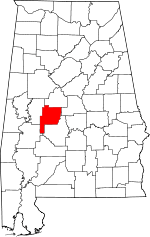 | |
| Unincorporated communities | ||
This article is issued from Wikipedia - version of the 11/3/2016. The text is available under the Creative Commons Attribution/Share Alike but additional terms may apply for the media files.