Hobyo Airport
| Obbia Airport | |||||||||||
|---|---|---|---|---|---|---|---|---|---|---|---|
| IATA: CMO – ICAO: HCMO | |||||||||||
| Summary | |||||||||||
| Airport type | Public | ||||||||||
| Owner | Somali Civil Aviation Authority | ||||||||||
| Serves | Hobyo, Somalia | ||||||||||
| Hub for | Hobyo | ||||||||||
| Elevation AMSL | 65 ft / 20 m | ||||||||||
| Coordinates | 5°21′05″N 48°31′32″E / 5.35139°N 48.52556°ECoordinates: 5°21′05″N 48°31′32″E / 5.35139°N 48.52556°E | ||||||||||
| Map | |||||||||||
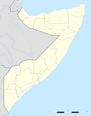 Obbia Airport Location of the airport in Somalia | |||||||||||
| Runways | |||||||||||
| |||||||||||
|
Sources: World Airport Codes[1] | |||||||||||
Obbia Airport (IATA: CMO, ICAO: HCMO) is an airport serving Hobyo, Somalia.
See also
- List of airports in Somalia
 Aviation portal
 Somalia portal
Notes
- ↑ "Obbia Airport (CMO)". World Airport Codes. Retrieved 18 September 2013.
References
- "Obbia Airport (CMO)". World Airport Codes. Retrieved 18 September 2013.
External links
- Airport information for Hobyo Airport at Great Circle Mapper. Source: DAFIF (effective October 2006).
This article is issued from Wikipedia - version of the 4/14/2016. The text is available under the Creative Commons Attribution/Share Alike but additional terms may apply for the media files.