Ohio State Route 339
| ||||
|---|---|---|---|---|
 | ||||
| Route information | ||||
| Maintained by ODOT | ||||
| Length: | 34.56 mi[1] (55.62 km) | |||
| Existed: | 1933[2][3] – present | |||
| Major junctions | ||||
| South end: |
| |||
|
| ||||
| North end: |
| |||
| Location | ||||
| Counties: | Washington, Morgan, Noble | |||
| Highway system | ||||
| ||||

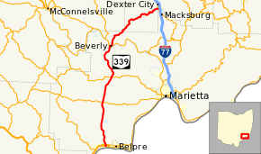
State Route 339 (SR 339) is a north–south state highway in southeastern Ohio, a U.S. state. The southern terminus of SR 339 is at SR 618 approximately 2 miles (3.2 km) west of Belpre, and less than 0.50 miles (0.80 km) south of the U.S. Route 50 (US 50)/SR 7/SR 32 expressway. The highway's northern terminus is a T-intersection with SR 821 about 0.75 miles (1.21 km) south of Dexter City.
Route description
SR 339's routing takes it through portions of the counties of Washington, Morgan and Noble. No portion of SR 339 is included within the National Highway System, a network of highways deemed most important for the economy, mobility and defense of the nation.[4]
History

SR 339 was established in 1933. It was initially a spur route that ran along its present alignment from its northern terminus at SR 821, at the time a part of US 21, southwesterly to approximately its southern intersection with County Road 75 (CR 75) in southern Noble County.[2][3] This would only be temporary, as in 1935 the highway was extended southwesterly to a new southern terminus at its eastern junction with SR 60, then designated as SR 77, in Beverly.[5][6]
In 1972, as a result of the designation of Interstate 76 (I-76) to Ohio, the SR 76 designation was eliminated. The route northwest of Beverly was given the designation of SR 83, while the portion south of Beverly became an extension of SR 339, which now ended at its present southern terminus at SR 618 near Belpre.[7][8]
Major intersections
| County | Location | mi[1] | km | Destinations | Notes |
|---|---|---|---|---|---|
| Washington | Belpre Township | 0.00 | 0.00 | ||
| 0.32 | 0.51 | Interchange | |||
| Barlow Township | 8.57 | 13.79 | |||
| Watertown Township | 13.49 | 21.71 | Southern end of SR 676 concurrency | ||
| 13.64 | 21.95 | Northern end of SR 676 concurrency | |||
| Beverly | 20.44 | 32.89 | Southern end of SR 60 concurrency | ||
| 20.62 | 33.18 | Northern end of SR 60 concurrency | |||
| Noble | Jefferson Township | 34.56 | 55.62 | ||
1.000 mi = 1.609 km; 1.000 km = 0.621 mi
| |||||
References
- 1 2 Ohio Department of Transportation. "Technical Services Straight Line Diagrams". Retrieved 2010-09-25.
- 1 2 Map of Ohio Showing State Highway System (MrSID) (Map). Cartography by ODOH. Ohio Department of Highways. 1932. Retrieved 2011-03-11.
- 1 2 Map of Ohio Showing State Highway System (MrSID) (Map). Cartography by ODOH. Ohio Department of Highways. 1933. Retrieved 2011-03-11.
- ↑ National Highway System: Ohio (PDF) (Map). Federal Highway Administration. December 2003. Retrieved 2015-06-18.
- ↑ Map of Ohio Showing State Highway System (MrSID) (Map). Cartography by ODOH. Ohio Department of Highways. 1934. Retrieved 2011-03-11.
- ↑ Official Ohio Highway Map (MrSID) (Map). Cartography by ODOH. Ohio Department of Highways. 1935. Retrieved 2011-03-11.
- ↑ Ohio Highway Map (MrSID) (Map). Cartography by ODOH. Ohio Department of Highways. 1971. Retrieved 2011-03-11.
- ↑ Ohio Highway Map (MrSID) (Map). Cartography by ODOH. Ohio Department of Highways. 1972. Retrieved 2011-03-11.