Ohio State Route 618
| ||||
|---|---|---|---|---|
 | ||||
| Route information | ||||
| Maintained by ODOT | ||||
| Length: | 7.45 mi[1] (11.99 km) | |||
| Existed: | 1937[2][3] – present | |||
| Major junctions | ||||
| West end: |
| |||
| East end: |
| |||
| Location | ||||
| Counties: | Washington | |||
| Highway system | ||||
| ||||

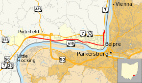
State Route 618 (SR 618) is a 7.45-mile (11.99 km) long east–west state highway in the southeastern quadrant of the U.S. state of Ohio. The western terminus of SR 618 is at an interchange with the concurrency of U.S. Route 50 (US 50), SR 7 and SR 32 about 3.25 miles (5.23 km) west of Belpre. Its eastern terminus is in northern Belpre at an interchange with SR 7.
Route description
All of SR 618 runs through the southwestern portion of Washington County. This highway is not included as a part of the National Highway System (NHS). The NHS is a system of routes deemed to be most important for the economy, mobility and defense of the country.[4]
History
SR 618 was applied in 1937. The highway was originally routed along what is now SR 7 and SR 32 and, in part, US 50, from the point that marks the western terminus of SR 618 into Belpre. Meanwhile, what is now designated as SR 618 was the routing of US 50 and SR 7 at the time.[2][3]
In 1965, SR 618 and US 50/SR 7 switched alignments. SR 618 was routed onto its present alignment, while US 50 and SR 7 was moved onto the former alignment of SR 618, which was widened into a four-lane divided highway simultaneous to the alignment swap.[5][6]
Major intersections
The entire route is in Washington County.
| Location | mi[1] | km | Destinations | Notes | |
|---|---|---|---|---|---|
| Belpre Township | 0.00 | 0.00 | Interchange; no access to US 50 eastbound / from US 50 westbound | ||
| 1.41 | 2.27 | Southern terminus of SR 339 | |||
| Belpre | 6.23 | 10.03 | Western end of SR 32 concurrency | ||
| 7.00 | 11.27 | Eastern end of SR 32 concurrency | |||
| 7.45 | 11.99 | Interchange; no access to SR 7 southbound / from SR 7 northbound | |||
1.000 mi = 1.609 km; 1.000 km = 0.621 mi
| |||||
References
- 1 2 Ohio Department of Transportation. "Technical Services Straight Line Diagrams: SR 618, Washington County" (PDF). Retrieved 2011-06-16.
- 1 2 Official Ohio Highway Map (MrSID) (Map). Cartography by ODOH. Ohio Department of Highways. 1936. Retrieved 2011-06-17.
- 1 2 Official Ohio Highway Map (MrSID) (Map). Cartography by ODOH. Ohio Department of Highways. 1937. Retrieved 2011-06-17.
- ↑ National Highway System: Ohio (PDF) (Map). Federal Highway Administration. December 2003. Retrieved 2011-06-16.
- ↑ Official Ohio Highway Map (MrSID) (Map). Cartography by ODOH. Ohio Department of Highways. 1964. Retrieved 2011-06-17.
- ↑ Official Ohio Highway Map (MrSID) (Map). Cartography by ODOH. Ohio Department of Highways. 1965. Retrieved 2011-06-17.