Ostravice (river)
| Ostravice | |
| River | |
_-_%C5%A0ance_dam.jpg) | |
| Named for: Ostrava City | |
| Country | Czech Republic |
|---|---|
| Region | Moravian-Silesian |
| Tributaries | |
| - left | Čeladenka |
| - right | Morávka |
| Settlements | Ostravice, Frýdlant nad Ostravicí, Frýdek-Místek, Ostrava |
| Primary source | Bílá Ostravice |
| - location | Moravian-Silesian Beskids |
| - elevation | 900 m (3,000 ft) |
| - coordinates | CZ 49°24′26″N 18°22′14″E / 49.40722°N 18.37056°E |
| Secondary source | Černá Ostravice |
| - coordinates | CZ 49°29′52″N 18°32′33″E / 49.49778°N 18.54250°E |
| Source confluence | |
| - coordinates | CZ 49°27′17″N 18°28′3″E / 49.45472°N 18.46750°E |
| Mouth | Oder River |
| - location | Ostrava |
| - elevation | 190 m (600 ft) |
| - coordinates | CZ 49°52′10″N 18°17′1″E / 49.86944°N 18.28361°ECoordinates: CZ 49°52′10″N 18°17′1″E / 49.86944°N 18.28361°E |
| Length | 64 km (40 mi) |
| Basin | 827 km2 (319 sq mi) |
| Discharge | |
| - average | 12.7 m3/s (448 cu ft/s) |
| - max | 933 m3/s (32,949 cu ft/s) |
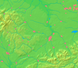
 _-_location_map.svg.png) The Ostravice from its two sources until its confluence with the Oder (magenta) and its watershed | |
 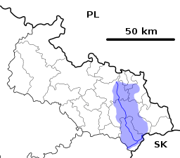 Location of Ostravice in the Moravian-Silesian Region | |
Ostravice (Polish: Ostrawica, German: Ostrawitza) is a river in Moravian-Silesian Region, Czech Republic. It originates in the Moravian-Silesian Beskids and then flows through Ostravice, Frýdlant nad Ostravicí, Frýdek-Místek and Paskov to Ostrava where it enters the Oder as its right tributary.
The river starts as the Ostravice after the confluence of the Bílá Ostravice (i.e., White Ostravice, considered its main source) and the Černá Ostravice (i.e. Black Ostravice). They are both streams flowing through deeply forested valleys which are important access roads to the resorts of Bílá and Bílý Kříž. Ostravice then creates a fresh water reservoir behind Šance Dam, for the industrial region around Ostrava finished in 1970. It has an area of 335 km2 (129 sq mi) and a 65 m (213 ft) high and 342 m (1,122 ft) long rockfill dam.
The Ostravice then flows through the rolling hills region between Ostravice and Frýdek-Místek and finally through the lowlands of the highly industrial Ostrava basin.
It partly forms the border between historical regions Moravia (left bank) and Silesia (more precisely Cieszyn Silesia) (right bank). It was first agreed as such in 1261 by a special treaty between Władysław Opolski, Duke of Opole and Racibórz and Ottokar II of Bohemia.[1] Later it was confirmed on 2 August 1297 between Mieszko I, Duke of Cieszyn and Dětřich, bishop of Olomouc.[2] It lost importance as a state border in 1327, when the Duchy of Teschen became a fee of the Kingdom of Bohemia.
Footnotes
- ↑ Panic, Idzi (2010). Śląsk Cieszyński w średniowieczu (do 1528) [Cieszyn Silesia in Middle Ages (until 1528)] (in Polish). Cieszyn: Starostwo Powiatowe w Cieszynie. p. 50. ISBN 978-83-926929-3-5.
- ↑ I. Panic, 2010, pp. 272, 400
References
- Ludvík, Marcel (1987). Beskydy, Turistický průvodce ČSSR. Praha: Olympia. 27-031-87.
- Rohlík, Jiří (2001). Moravskoslezské Beskydy, Soubor turistických map 1:50 000. Praha: TRASA, s.r.o. ISBN 80-85999-29-3.
- "Těšínsko z pohledu fyzické geografie". Muzeum Těšínska. Retrieved 2007-01-14.
Tributaries of the Oder / Odra | ||
|---|---|---|
| Main tributaries of the left bank |
| 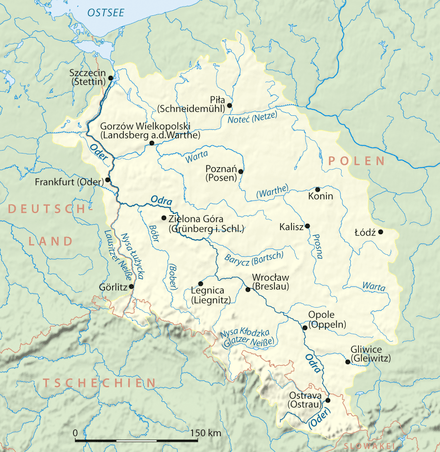 |
| Main tributaries of the right bank | ||
| Distributary | ||
| Cities | ||