Ouaddaï Prefecture
| Ouaddaï Prefecture Préfecture du Ouaddaï | |||||
| Prefecture of Chad | |||||
| |||||
|
| |||||
 | |||||
| Capital | Abéché 13°49′N 20°50′E / 13.817°N 20.833°ECoordinates: 13°49′N 20°50′E / 13.817°N 20.833°E | ||||
| Government | Prefecture | ||||
| Historical era | Cold War | ||||
| • | Established[1] | 13 February 1960 | |||
| • | Separation of Biltine Prefecture | 1960[1] | |||
| • | Disestablished[1] | 1 September 1999 | |||
| Area | |||||
| • | 1960 | 75,000 km2 (28,958 sq mi) | |||
| • | 1993 | 76,240 km2 (29,436 sq mi) | |||
| Population | |||||
| • | 1960 | 306,265 | |||
| Density | 4.1 /km2 (10.6 /sq mi) | ||||
| • | 1993 | 543,900 | |||
| Density | 7.1 /km2 (18.5 /sq mi) | ||||
| Political subdivisions | Sub-prefectures (1993)[2]
| ||||
| Area and population source:[1] | |||||

This article refers to one of the former prefectures of Chad. From 2002 the country was divided into 18 regions.
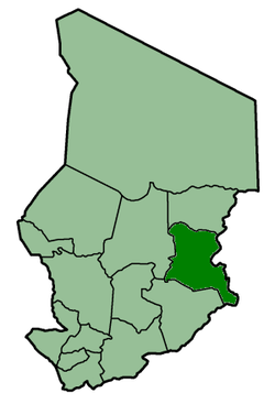
Ouaddaï was one of the 14 prefectures of Chad. Located in the east of the country, Ouaddaï covered an area of 76,240 square kilometers and had a population of 543,900 in 1993. Its capital was Abéché.
See also
External links
References
- 1 2 3 4 "Administrative Divisions of Countries: Regions of Chad". www.statoids.com.
- ↑ "Administrative Divisions of Countries: Departments of Chad". www.statoids.com.
| |||
|
Batha · Biltine · Borkou-Ennedi-Tibesti · Chari-Baguirmi · Guéra · Kanem · Lac · Logone Occidental · Logone Oriental · Mayo-Kébbi · Moyen-Chari · Ouaddaï · Salamat · Tandjilé · | |||
|
See also : Regions of Chad - Departments of Chad |
This article is issued from Wikipedia - version of the 11/24/2016. The text is available under the Creative Commons Attribution/Share Alike but additional terms may apply for the media files.