Ozawkie, Kansas
| Ozawkie, Kansas | |
|---|---|
| City | |
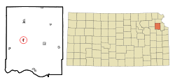 Location within Jefferson County and Kansas | |
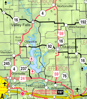 KDOT map of Jefferson County (legend) | |
| Coordinates: 39°14′00″N 95°27′57″W / 39.23333°N 95.46583°W | |
| Country | United States |
| State | Kansas |
| County | Jefferson |
| Government | |
| • Type | Mayor/Council |
| • Mayor | Christopher Feuerborn |
| • City Clerk | Melissa Zimmerman |
| Area[1] | |
| • Total | 0.38 sq mi (0.98 km2) |
| • Land | 0.38 sq mi (0.98 km2) |
| • Water | 0 sq mi (0 km2) |
| Elevation | 1,001 ft (305 m) |
| Population (2010)[2] | |
| • Total | 645 |
| • Estimate (2012[3]) | 638 |
| • Density | 1,700/sq mi (660/km2) |
| Time zone | Central (CST) (UTC-6) |
| • Summer (DST) | CDT (UTC-5) |
| ZIP code | 66070 |
| Area code(s) | 785 |
| FIPS code | 20-53925 [4] |
| GNIS feature ID | 0478489 [5] |
| Website | ozawkie.org |
Ozawkie is a city in Jefferson County, Kansas, United States. As of the 2010 census, the city population was 645.[6] It is part of the Topeka, Kansas Metropolitan Statistical Area. Located adjacent to Perry Lake, Ozawkie formerly existed in a different location but was relocated prior to the reservoir's construction.[7]
History
It was originally named Osawkee and became Jefferson County's original county seat in 1855. Ozawkie was the name of a Sauk Indian.[8] The county seat was transferred to Oskaloosa in 1858.[9]
In 1930, there were rumors the US Army Corps of Engeinners building a Dam and relocation would be required. However, it wasn't until 1954 that the Perry Dam Project was approved. Since Ozawkie wasn't incorporated, the US Government would not relocate it. Citizens came together to form a non-profit organization to help move Ozawkie. In 1966, Ozawkie was relocated to higher ground west of the original town site and a Water Tower, School and 26 homes were built.
In 1967, Ozawkie was incorporated.[10]
Geography
Ozawkie is located at 39°14′00″N 95°27′57″W / 39.233201°N 95.465709°WCoordinates: 39°14′00″N 95°27′57″W / 39.233201°N 95.465709°W (39.233201, -95.465709).[11] According to the United States Census Bureau, the city has a total area of 0.38 square miles (0.98 km2), all of it land.[1]
Demographics
| Historical population | |||
|---|---|---|---|
| Census | Pop. | %± | |
| 1970 | 137 | — | |
| 1980 | 472 | 244.5% | |
| 1990 | 403 | −14.6% | |
| 2000 | 552 | 37.0% | |
| 2010 | 645 | 16.8% | |
| Est. 2015 | 633 | [12] | −1.9% |
| U.S. Decennial Census | |||
2010 census
As of the census[2] of 2010, there were 645 people, 231 households, and 195 families residing in the city. The population density was 1,697.4 inhabitants per square mile (655.4/km2). There were 246 housing units at an average density of 647.4 per square mile (250.0/km2). The racial makeup of the city was 95.5% White, 0.6% African American, 1.4% Native American, 0.3% from other races, and 2.2% from two or more races. Hispanic or Latino of any race were 2.6% of the population.
There were 231 households of which 39.8% had children under the age of 18 living with them, 70.6% were married couples living together, 10.0% had a female householder with no husband present, 3.9% had a male householder with no wife present, and 15.6% were non-families. 13.0% of all households were made up of individuals and 6.5% had someone living alone who was 65 years of age or older. The average household size was 2.79 and the average family size was 3.02.
The median age in the city was 37.5 years. 28.7% of residents were under the age of 18; 7% were between the ages of 18 and 24; 21.7% were from 25 to 44; 26.6% were from 45 to 64; and 16% were 65 years of age or older. The gender makeup of the city was 50.4% male and 49.6% female.
2000 census
As of the census[4] of 2000, there were 552 people, 202 households, and 167 families residing in the city. The population density was 1,797.3 people per square mile (687.5/km²). There were 216 housing units at an average density of 703.3 per square mile (269.0/km²). The racial makeup of the city was 97.28% White, 0.72% African American, 1.27% Native American, 0.18% Asian, and 0.54% from two or more races. Hispanic or Latino of any race were 0.36% of the population.
There were 202 households out of which 36.1% had children under the age of 18 living with them, 77.2% were married couples living together, 5.0% had a female householder with no husband present, and 17.3% were non-families. 13.9% of all households were made up of individuals and 7.9% had someone living alone who was 65 years of age or older. The average household size was 2.73 and the average family size was 3.03.
In the city the population was spread out with 27.4% under the age of 18, 4.3% from 18 to 24, 25.4% from 25 to 44, 29.3% from 45 to 64, and 13.6% who were 65 years of age or older. The median age was 40 years. For every 100 females there were 95.7 males. For every 100 females age 18 and over, there were 92.8 males.
The median income for a household in the city was $62,969, and the median income for a family was $67,292. Males had a median income of $42,308 versus $27,375 for females. The per capita income for the city was $21,857. About 1.1% of families and 2.3% of the population were below the poverty line, including none of those under the age of eighteen or sixty-five or over.
See also
References
- 1 2 "US Gazetteer files 2010". United States Census Bureau. Retrieved 2012-07-06.
- 1 2 "American FactFinder". United States Census Bureau. Retrieved 2012-07-06.
- ↑ "Population Estimates". United States Census Bureau. Retrieved 2013-05-29.
- 1 2 "American FactFinder". United States Census Bureau. Retrieved 2008-01-31.
- ↑ "US Board on Geographic Names". United States Geological Survey. 2007-10-25. Retrieved 2008-01-31.
- ↑ "2010 City Population and Housing Occupancy Status". U.S. Census Bureau. Retrieved September 18, 2011.
- ↑ "Perry Lake: Lake of Trails" (PDF). Heartland Engineer. April 2006. pp. 13–14. Archived from the original (PDF) on 2007-06-27. Retrieved 2007-05-07.
- ↑ "Profile for Ozawkie, Kansas, KS". ePodunk. Retrieved 11 June 2014.
- ↑ Blackmar, Frank Wilson (1912). Kansas: A Cyclopedia of State History, Volume 2. Standard Publishing Company. p. 430.
- ↑ History of Ozawkie
- ↑ "US Gazetteer files: 2010, 2000, and 1990". United States Census Bureau. 2011-02-12. Retrieved 2011-04-23.
- ↑ "Annual Estimates of the Resident Population for Incorporated Places: April 1, 2010 to July 1, 2015". Retrieved July 2, 2016.
External links
| Wikimedia Commons has media related to Ozawkie, Kansas. |
- City
- Schools
- USD 340, local school district
- Maps
- Ozawkie City Map, KDOT
Municipalities and communities of Jefferson County, Kansas, United States | ||
|---|---|---|
| Cities |  | |
| CDP | ||
| Unincorporated communities | ||
| Townships | ||