Péruwelz
| Péruwelz | |||
|---|---|---|---|
| Municipality | |||
.jpg) | |||
| |||
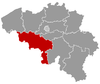
 Péruwelz Location in Belgium | |||
|
Municipality in the province of Hainaut  | |||
| Coordinates: 50°31′N 03°35′E / 50.517°N 3.583°ECoordinates: 50°31′N 03°35′E / 50.517°N 3.583°E | |||
| Country | Belgium | ||
| Community | French Community | ||
| Region | Wallonia | ||
| Province | Hainaut | ||
| Arrondissement | Tournai | ||
| Government | |||
| • Mayor | Daniel Westrade (PS) | ||
| • Governing party/ies | PS, AC | ||
| Area | |||
| • Total | 60.56 km2 (23.38 sq mi) | ||
| Population (1 January 2016)[1] | |||
| • Total | 17,132 | ||
| • Density | 280/km2 (730/sq mi) | ||
| Postal codes | 7600-7608 | ||
| Area codes | 069 | ||
| Website | www.peruwelz.be | ||


Péruwelz is a Walloon municipality located in the Belgian province of Hainaut. On January 1, 2006, Péruwelz had a total population of 16,843. The total area is 60.56 km² which gives a population density of 278 inhabitants per km².
Péruwelz is pronounced [peʀwe] or [pɛʀwe]; in Picard (the Western Hainaut's dialect), the city's name is "Piérwé", and is pronounced [pieʀwe] or [piɛʀwe].
This municipality is more specifically situated in Western Hainaut, also called Walloon Picardy. Péruwelz is also near France, near the cities of "Condé-sur-l'Escaut", "Vieux Condé", "Hergnies", and is near the forest of Bon-Secours, the location of the castle of (l')Hermitage.
Composition of the municipality

The current municipality of Péruwelz was formed in 1977 when the following ten municipalities were joined:
- I. Péruwelz
- II. Bon-Secours
- III. Roucourt
- IV. Bury (site of Bitremont Castle, or the Château de Bitremont)
- V. Braffe
- VI. Baugnies
- VII. Wasmes-Audemez-Briffoeil
- VIII. Brasménil
- IX. Wiers
- X. Callenelle
The municipality also includes these villages:
- (XI.) Briffœil
- (XII.) Audemez
- (XIII.) Ringies
- (XIV.) Ponange
Fountains
Péruwelz has a number of natural springs:
- The Dubuisson-Copin's washing-place fountain is in the communal gardens created in 1912. This fountain is the busiest.
- De la Ferté Fountain
- Du Flassart fountain, on the little place since 1898.
- Jaunay-Clan fountain. Jaunay-Clan is the name of the commune paired with Péruwelz. This fountain is made of stones from Jaunay-Clan.
- Du Maréchal fountain. In the past named "Magrite fountain", "des Quatre-Cailloux fountain", and "des cailloux gris posés de chant fountain" until it was named "Du Maréchal fountain" in 1887 after its restoration.
- Tanchou fountain.
- De Verquesies fountain
Certain springs are not potable, tests are performed every day.
 Simon Garden
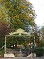 Dubuisson-Copin's fountain
References
- ↑ Population per municipality as of 1 January 2016 (XLS; 397 KB)
External links
-
 Media related to Péruwelz at Wikimedia Commons
 |
Tournai | Leuze-en-Hainaut | | |
| Antoing Flines-lès-Mortagne (FR-59) |
|
Belœil Bernissart | ||
| ||||
| | ||||
| Hergnies, Vieux-Condé, Condé-sur-l'Escaut (all in FR-59) |