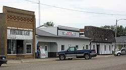
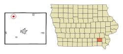
Packwood, Iowa
| Packwood, Iowa | |
|---|---|
| City | |
 | |
 Location of Packwood, Iowa | |
| Coordinates: 41°8′0″N 92°4′59″W / 41.13333°N 92.08306°WCoordinates: 41°8′0″N 92°4′59″W / 41.13333°N 92.08306°W | |
| Country |
|
| State |
|
| County | Jefferson |
| Area[1] | |
| • Total | 0.76 sq mi (1.97 km2) |
| • Land | 0.76 sq mi (1.97 km2) |
| • Water | 0 sq mi (0 km2) |
| Elevation | 810 ft (247 m) |
| Population (2010)[2] | |
| • Total | 204 |
| • Estimate (2012[3]) | 205 |
| • Density | 268.4/sq mi (103.6/km2) |
| Time zone | Central (CST) (UTC-6) |
| • Summer (DST) | CDT (UTC-5) |
| ZIP code | 52580 |
| Area code(s) | 319 |
| FIPS code | 19-60915 |
| GNIS feature ID | 0459986 |
Packwood is a city in Jefferson County, Iowa, United States. The population was 204 at the 2010 census.
Geography
Packwood is located at 41°08′00″N 92°04′59″W / 41.133319°N 92.083138°W (41.133319, -92.083138).[4]
According to the United States Census Bureau, the city has a total area of 0.76 square miles (1.97 km2), all of it land.[1]
Demographics
| Historical populations | ||
|---|---|---|
| Year | Pop. | ±% |
| 1900 | 284 | — |
| 1910 | 264 | −7.0% |
| 1920 | 294 | +11.4% |
| 1930 | 208 | −29.3% |
| 1940 | 256 | +23.1% |
| 1950 | 211 | −17.6% |
| 1960 | 215 | +1.9% |
| 1970 | 157 | −27.0% |
| 1980 | 210 | +33.8% |
| 1990 | 208 | −1.0% |
| 2000 | 223 | +7.2% |
| 2010 | 204 | −8.5% |
| 2014 | 212 | +3.9% |
| 2015 | 215 | +1.4% |
| Source:"American FactFinder". United States Census Bureau. and Iowa Data Center Source: | ||
2010 census
As of the census[2] of 2010, there were 204 people, 85 households, and 52 families residing in the city. The population density was 268.4 inhabitants per square mile (103.6/km2). There were 96 housing units at an average density of 126.3 per square mile (48.8/km2). The racial makeup of the city was 96.6% White, 1.0% African American, 0.5% Pacific Islander, and 2.0% from two or more races. Hispanic or Latino of any race were 0.5% of the population.
There were 85 households of which 28.2% had children under the age of 18 living with them, 52.9% were married couples living together, 3.5% had a female householder with no husband present, 4.7% had a male householder with no wife present, and 38.8% were non-families. 30.6% of all households were made up of individuals and 14.1% had someone living alone who was 65 years of age or older. The average household size was 2.40 and the average family size was 3.04.
The median age in the city was 41.5 years. 30.4% of residents were under the age of 18; 1.6% were between the ages of 18 and 24; 21.6% were from 25 to 44; 30.5% were from 45 to 64; and 16.2% were 65 years of age or older. The gender makeup of the city was 44.1% male and 55.9% female.
2000 census
As of the census[6] of 2000, there were 223 people, 101 households, and 65 families residing in the city. The population density was 289.9 people per square mile (111.8/km2). There were 108 housing units at an average density of 140.4 per square mile (54.2/km2). The racial makeup of the city was 98.65% White and 1.35% Native American.
There were 101 households out of which 24.8% had children under the age of 18 living with them, 56.4% were married couples living together, 4.0% had a female householder with no husband present, and 35.6% were non-families. 34.7% of all households were made up of individuals and 17.8% had someone living alone who was 65 years of age or older. The average household size was 2.21 and the average family size was 2.86.
In the city the population was spread out with 23.3% under the age of 18, 5.4% from 18 to 24, 27.8% from 25 to 44, 23.8% from 45 to 64, and 19.7% who were 65 years of age or older. The median age was 40 years. For every 100 females there were 85.8 males. For every 100 females age 18 and over, there were 85.9 males.
The median income for a household in the city was $32,000, and the median income for a family was $37,321. Males had a median income of $28,438 versus $16,250 for females. The per capita income for the city was $17,081. None of the families and 0.8% of the population were living below the poverty line, including no under eighteens and 3.3% of those over 64.
References
- 1 2 "US Gazetteer files 2010". United States Census Bureau. Retrieved 2012-05-11.
- 1 2 "American FactFinder". United States Census Bureau. Retrieved 2012-05-11.
- ↑ "Population Estimates". United States Census Bureau. Retrieved 2013-05-23.
- ↑ "US Gazetteer files: 2010, 2000, and 1990". United States Census Bureau. 2011-02-12. Retrieved 2011-04-23.
- ↑ "Census of Population and Housing". Census.gov. Retrieved June 4, 2015.
- ↑ "American FactFinder". United States Census Bureau. Retrieved 2008-01-31.
Municipalities and communities of Jefferson County, Iowa, United States | ||
|---|---|---|
| Cities | ||
| Townships |
| |
| Unincorporated communities | ||
| Footnotes | ‡This populated place also has portions in an adjacent county or counties | |