Palo, Leyte
| Palo | ||
|---|---|---|
| Municipality | ||
|
| ||
| ||
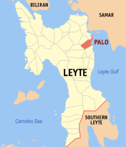 Location in Leyte province | ||
.svg.png) Palo Location within the Philippines | ||
| Coordinates: 11°09′27″N 124°59′27″E / 11.15750°N 124.99083°ECoordinates: 11°09′27″N 124°59′27″E / 11.15750°N 124.99083°E | ||
| Country |
| |
| Region | Eastern Visayas (Region VIII) | |
| Province | Leyte | |
| District | 1st District of Leyte | |
| Founded | 1768 | |
| Barangays | 33 | |
| Government[1] | ||
| • Mayor | Remedios L. Petilla | |
| Area[2] | ||
| • Total | 221.27 km2 (85.43 sq mi) | |
| • Land | 80.19 km2 (30.96 sq mi) | |
| Population (2015)[3] | ||
| • Total | 70,052 | |
| • Density | 320/km2 (820/sq mi) | |
| Time zone | PST (UTC+8) | |
| ZIP code | 6501 | |
| Dialing code | 53 | |
| Income class | 3rd class; partially urban | |

Palo is a third class municipality in the province of Leyte, Philippines. According to the 2015 census, it has a population of 70,052 people.[3]
The municipality is the seat of most government departments, bureaus and regional offices of Region VIII, although some are situated at the neighboring city of Tacloban. The town is also home to the offices of the ecclesiastical government of the Archdiocese of Palo; the archbishop's residence; as well as the secondary, tertiary and theology seminaries of the archdiocese.
Geography
The municipality is located in the north-eastern part of the province of Leyte, 8 miles from the capital city of Tacloban.
Palo is politically subdivided into 33 barangays.[2]
- Anahaway
- Arado
- Baras
- Barayong
- Cabarasan Daku
- Cabarasan Guti
- Campetic
- Candahug
- Cangumbang
- Canhidoc
- Capirawan
- Castilla
- Cogon
- San Joaquin
- Gacao
- Guindapunan
- Libertad
- Naga-naga
- Pawing
- Buri (Poblacion barangay)
- Cavite East (Pob. barangay)
- Cavite West (Pob.)
- Luntad (Pob.)
- Santa Cruz (Pob.)
- Salvacion
- San Agustin
- San Antonio
- San Isidro
- San Jose
- St. Michael (Pob.)
- Tacuranga
- Teraza
- San Fernando
History
The discovery of the advancing communities of Palo dates back to the early 16th century A.D. along the banks of Bangon River. However, local historians believe that the settlement of Palo started as early as the 10th to 13th century A.D..
The first known settlement were the kingdom of Takuranga, first name of Palo under King Guban, and the Kingdom of Kaluugan, the second name of Palo under King Pitik. From the 14th to the 16th centuries, some other settlements were formed which also became the succeeding names of Palo, until finally in 1550 Don Miguel Lopez de Legaspi coalesced the settlements and named the new confederation "Palo". The other settlements were Kasangitan, Binangalan, Kasuguran, Bunga, Bangon and Guindapunan. The settlers of Bunga played a vital role in the history of Palo, having formed the settlement of Bangon which is now the town center. Palo formally became a town in 1768 with Kapitan Balasabas as its first administration.
Accordingly, the early settlers of Palo were the clans of Panganuron, Kadampog, Manlangit, Kumago, Kawaring, Kabalhin, Kumagong, Maglain, Bilyu and Dilyu.
Palo is considered to be one of the most historical towns of Leyte. It is well known as the site of Gen. Douglas MacArthur's return to the Philippines together with Philippine and American military forces after a period of exile in 1944.[4][5] Hill 522, a hill located near the town center, was the site of fierce fighting between Allied and Japanese forces during the Second World War. The metropolitan cathedral of the archdiocese, located right across Palo's municipal hall, was used as a hospital for wounded Filipino and American forces. A memorial now stands at the beach site where MacArthur and his troops landed, locally known as the MacArthur's Park. The first Gabaldon Building is also situated in Brgy. San Joaquin Palo, Leyte. It was inaugurated by President Sergio Osmeña.
Palo was also once the capital of Leyte. The town's Purissima Bridge was the first steel bridge built in the province.
In 1957, sitio Campitic was converted into a barrio,[6] while barrio Baras-Candahug was divided into two: Baras and Candahug.[7] Barrio Malirong was renamed as Libertad.[8]
On November 8, 2013, Palo was severely struck by Typhoon Haiyan (Yolanda), which destroyed a large portion of Eastern Visayas and killed a number of residents in the town.[9] On January 17, 2015, Pope Francis visited the town as part of his papal visit to the Philippines to meet with the surviving victims of the typhoon. He also blessed the Pope Francis Center for the Poor and met with priests, seminarians, other religious figures, and surviving victims of the typhoon at the Palo Cathedral before leaving Leyte.[10]
Demographics
| Population census of Palo | ||
|---|---|---|
| Year | Pop. | ±% p.a. |
| 1990 | 38,100 | — |
| 1995 | 43,095 | +2.34% |
| 2000 | 47,982 | +2.33% |
| 2007 | 56,781 | +2.35% |
| 2010 | 62,727 | +3.69% |
| Source: National Statistics Office[11] | ||
Literacy rate in Palo is 99.5%.
The town's native language is Waray-Waray, the major language and lingua franca in the Eastern Visayas region.
Economy
Palo is the seat of the 6.8-hectare Leyte Information and Communications Technology (ICT) Park and the 22-hectare Leyte Mikyu Economic Zone.[12] The Leyte ICT Park hosts two BPOs while the Leyte Mikyu Ecozone is undergoing development.
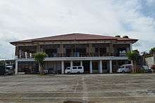
The town is very active in commerce and in tourism. It attracts a significant number of tourists every year. The town also has its historic Municipal Building which was the former Seat of the Provincial Government of Leyte. Its location is conducive to and ideal for trading and commerce.
The main source of income for most of the citizenry is the buying and selling of farm products and the production and fermentation of the local coconut wine "tuba".[13][14]
Religion
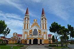
Palo is believed to be a sacred place by clerical observers. It is the seat of the ecclesiastical province, the Archdiocese, where the Roman Catholic Archbishop resides in Bukid Tabor. One can find the Metropolitan Cathedral in Palo. Also, the seedbed of vocations to the priesthood is found at the Sacred Heart Seminary and the St. John the Evangelist School of Theology. Two Paloan nuns were also Superior Generals in their respective congregations. To date, there are 79 ordained priests and 106 nuns from the town alone.
Educational institutions
Private
- Saint Paul School of Professional Studies
- Sacred Heart Seminary
- St. John The Evangelist School of Theology
- Palo Angelicum
- St. Mary's Academy Of Palo
- St Agustine College of Practical Nursing
- Bethel International School
- Zion Bible College
- AMA Computer College
- ELA English Language Academy
- Alpha-Omega Learning Center
Public
- UP Manila School of Health Sciences
- Philippine Science High School - Eastern Visayas Campus
- Palo National High School
- Palo Central School (Regular)
- Palo Central School (SPED)
- San Joaquin Central School
- San Joaquin National High School
- Libertad Elementary School
- Anahaway National High School
- Luntad Elementary School
- Naga-Naga Elementary School
- Arado Elementary School
- Pawing Elementary School
- Guindapunan Elementary School
- Baras Elementary School
- Canhidoc Elementary School
- Palo National High School- Pawing Annex
Tourist attractions
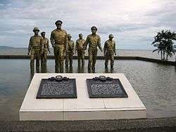
- MacArthur Landing Memorial National Park
- Guinhangdan Hill (now a forest reserve)
- Japanese Shrine in Brgy. Caloogan
- Red Beach - The landmark that has brought Palo to the annals of world history is the Red Beach, in barangay Candahug, where Gen. Douglas MacArthur first landed to liberate the Philippines from the Japanese occupation on October 20, 1944.[4]
- WW2 Memorial for the Filipino Soldiers
- Palo Metropolitan Cathedral
- Palo Binangalan coral reefs
- Palo Mangrove Reservation (open season for duck hunting whole year round)
- Palo Municipal Library and Heritage Museum
Cultural Organizations
- Palo Culture and the Arts Organization-PCAO
- Shadow Arts Theater Organization
- Enchanting Palo Brass Band
- Singing Angels' Choir of Palo
- Palo Ambassadors Arts and Culture Inc.
- Rah Rah Rousers and Rouserettes
References
- ↑ "Municipalities". Quezon City, Philippines: Department of the Interior and Local Government. Retrieved 24 June 2013.
- 1 2 "Province: Leyte". PSGC Interactive. Makati City, Philippines: National Statistical Coordination Board. Retrieved 24 June 2013.
- 1 2 "Region VIII (EASTERN VISAYAS)". Census of Population (2015): Total Population by Province, City, Municipality and Barangay (Report). PSA. Retrieved 20 June 2016.
- 1 2 "Leyte Landing". Official Gazette of the Republic of the Philippines. Retrieved 25 January 2015.
- ↑ Misagal, Monch Mikko E. (16 October 2014). "Did MacArthur land on Leyte before Oct. 20, 1944?". Manila Bulletin. Retrieved 25 January 2015.
- ↑ "R.A. No. 1722: An Act Converting the Sitio of Campitic in the Municipality of Palo, Province of Leyte, into a Barrio to Be Known As the Barrio of Campitic". LawPH.com. Retrieved 2011-04-12.
- ↑ "R.A. No. 1723: An Act Creating the Barrios of Baras and Candahug in the Municipality of Palo, Province of Leyte". LawPH.com. Retrieved 2011-04-12.
- ↑ "R.A. No. 1740: An Act Changing the Name of the Barrio of Malirong, Municipality of Palo, Province of Leyte, to Libertad". LawPH.com. Retrieved 2011-04-12.
- ↑ "Tacloban City: Hundreds Dead in City and Leyte Province After Typhoon". Epoch Time. Retrieved 2013-11-11.
- ↑ "Pope Francis arrives in Leyte to console Yolanda victims". Rappler. 17 January 2015. Retrieved 17 January 2015.
- ↑ "Total Population by Province, City, Municipality and Barangay: as of May 1, 2010" (PDF). 2010 Census of Population and Housing. National Statistics Office. Retrieved 24 June 2013.
- ↑ http://peza.gov.ph
- ↑ "DOST Eyes Palo, Leyte as Country's Coco Wine Capital". Interaksyon.com. Philippines News Agency. 1 July 2013. Retrieved 25 January 2015.
- ↑ "Boosting Philippines' Coconut Wine Industry". Tempo. 20 July 2013. Retrieved 25 January 2015.
External links
| Wikimedia Commons has media related to Palo, Leyte. |
| Wikivoyage has a travel guide for Palo, Leyte. |
- Philippine Standard Geographic Code
- Philippine Census Information
- Local Governance Performance Management System
- Online Lineyte-Samarnon (Waray-Waray)-English Dictionary
- Leyte Tips | Leyte Jobs | Leyte News | Tour Leyte
 |
Santa Fe | Tacloban | | |
| Pastrana | |
San Pedro Bay | ||
| ||||
| | ||||
| Tanauan |
Tacloban (capital) | |
| Municipalities |
|
| Component city | |
| Independent component city |
|
| Highly urbanized city |
|