Paniri
| Paniri | |
|---|---|
 The Paniri volcano as seen from the south, with the summit of the San Pablo volcano in the background. | |
| Highest point | |
| Elevation | 5,960 m (19,550 ft) [1] |
| Prominence | 1,653 m (5,423 ft) [1] |
| Listing | Ultra |
| Coordinates | 22°03′33″S 68°13′42″W / 22.05917°S 68.22833°WCoordinates: 22°03′33″S 68°13′42″W / 22.05917°S 68.22833°W [2] |
| Geography | |
 Paniri Chile | |
| Location | Antofagasta, Chile |
| Parent range | Andes |
| Geology | |
| Mountain type | Stratovolcano |
| Last eruption | Unknown |
| Climbing | |
| First ascent | pre-Columbian |
Paniri (Aymara) is a stratovolcano located in El Loa Province, Antofagasta Region, Chile, and near the border with Bolivia. To its northwest lie the twin volcanoes San Pedro and San Pablo, and to its southeast lies Cerro del León, from which it is separated by the huge Chao lava dome.
Claudio Lucero and Nelson Muñoz made the first recorded ascent of Paniri in 1972. They found archaeological remains on its summit.[3]
See also
- List of volcanoes in Chile
- San Pedro de Inacaliri River
- Salado River
- List of Ultras of South America
- List of andean peaks with known pre-columbian ascents
References
- 1 2 "Cerro Paniri, Chile". Peakbagger.com.
- ↑ "Argentina and Chile, North: Ultra-Prominences" Peaklist.org. Retrieved 2012-04-28.
- ↑ Humberto Barrera, "Paniri", American Alpine Journal, 1974, p. 194. Available at AAJ Online (PDF).
External links
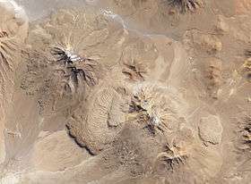
Paniri (top left), the Chao dacite dome complex, and Cerro del León, viewed from Landsat 8, 2013
This article is issued from Wikipedia - version of the 9/27/2015. The text is available under the Creative Commons Attribution/Share Alike but additional terms may apply for the media files.