Pantops, Virginia
| Pantops | |
|---|---|
| CDP | |
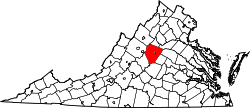
 Pantops Location within the Commonwealth of Virginia | |
| Coordinates: 38°1′51″N 78°26′41″W / 38.03083°N 78.44472°WCoordinates: 38°1′51″N 78°26′41″W / 38.03083°N 78.44472°W | |
| Country | United States |
| State | Virginia |
| County | Albemarle |
| Population (2010) | |
| • Total | 3,027 |
| Time zone | Eastern (EST) (UTC-5) |
| • Summer (DST) | EDT (UTC-4) |
| ZIP codes | 22911 |
| FIPS code | 51-60500 |
| GNIS feature ID | 2584899[1] |
Pantops is a census-designated place in Albemarle County, Virginia.[1] The population as of the 2010 Census was 3,027.[2] It is a suburban area located just across the Rivanna River east of Charlottesville, and includes Pantops Mountain.
References
- 1 2 "Pantops Census Designated Place". Geographic Names Information System. United States Geological Survey. Retrieved August 13, 2013.
- ↑ Virginia Trend Report 2: State and Complete Places (Sub-state 2010 Census Data). Missouri Census Data Center. Accessed 2011-06-08.
This article is issued from Wikipedia - version of the 9/3/2016. The text is available under the Creative Commons Attribution/Share Alike but additional terms may apply for the media files.