Perry, Florida
| Perry, Florida | |
|---|---|
| City | |
|
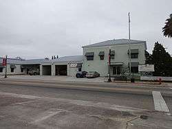
Perry City Hall and Fire Department | |
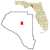 Location in Taylor County and the state of Florida | |
| Coordinates: 30°6′52″N 83°34′57″W / 30.11444°N 83.58250°WCoordinates: 30°6′52″N 83°34′57″W / 30.11444°N 83.58250°W | |
| Country |
|
| State |
|
| County | Taylor |
| Area | |
| • Total | 9.3 sq mi (24.1 km2) |
| • Land | 9.3 sq mi (24.1 km2) |
| • Water | 0 sq mi (0 km2) |
| Elevation | 46 ft (14 m) |
| Population (2010) | |
| • Total | 7,017 |
| • Density | 736.2/sq mi (284.1/km2) |
| Time zone | Eastern (EST) (UTC-5) |
| • Summer (DST) | EDT (UTC-4) |
| ZIP codes | 32347-32348 |
| Area code(s) | 850 |
| FIPS code | 12-56150[1] |
| GNIS feature ID | 0288724[2] |
Perry is a city in Taylor County, Florida, United States. As of 2010, the population recorded by the U.S. Census Bureau is 7,017.[3] It is the county seat of Taylor County.[4] The city was named for Madison Starke Perry, fourth Governor of the State of Florida and a Confederate colonel during the American Civil War.[5]
Geography
Perry is located at 30°06′52″N 83°34′57″W / 30.114311°N 83.582609°W.[6]
According to the United States Census Bureau, the city has a total area of 9.3 square miles (24 km2), all land.
Perry is approximately 50 miles (80 km) southeast of Tallahassee.[7]
History
The Perry Race Riot occurred in Perry on 14 and 15 December 1922, during which whites burned Charles Wright at the stake and attacked the black community of Perry after the murder of a white schoolteacher.[8] On the day following Wright's lynching two more black men were shot and hanged; whites then burned the town's black school, Masonic lodge, church, amusement hall, and several families' homes.[8][9]
Demographics
| Historical population | |||
|---|---|---|---|
| Census | Pop. | %± | |
| 1910 | 1,012 | — | |
| 1920 | 1,956 | 93.3% | |
| 1930 | 2,744 | 40.3% | |
| 1940 | 2,668 | −2.8% | |
| 1950 | 2,797 | 4.8% | |
| 1960 | 8,030 | 187.1% | |
| 1970 | 7,701 | −4.1% | |
| 1980 | 8,254 | 7.2% | |
| 1990 | 7,151 | −13.4% | |
| 2000 | 6,847 | −4.3% | |
| 2010 | 7,017 | 2.5% | |
| Est. 2015 | 7,055 | [10] | 0.5% |
As of the census[1] of 2010, there were 7,017 people, 2,661 households, and 1,828 families residing in the city. The population density was 748.0 people per square mile (284.6/km²). There were 3,073 housing units at an average density of 330.9 per square mile (127.7/km²) The racial makeup of the city was 55.0% White 40.1% African American, 0.5% Native American, 1.4% Asian and 2.1% from two or more races. Hispanic or Latino of any race were 2.2% of the population.
There were 2,661 households out of which 33.3% had children under the age of 18 living with them, 40.4% were married couples living together, 23.8% had a female householder with no husband present, and 31.3% were non-families. 27.0% of all households were made up of individuals and 12.4% had someone living alone who was 65 years of age or older. The average household size was 2.52 and the average family size was 3.02.
In the city the population was spread out with 28.4% under the age of 18, 8.8% from 18 to 24, 26.3% from 25 to 44, 21.5% from 45 to 64, and 15.0% who were 65 years of age or older. The median age was 36 years. For every 100 females there were 87.8 males. For every 100 females age 18 and over, there were 84.3 males.
The median income for a household in the city was $25,986, and the median income for a family was $29,602. Males had a median income of $26,595 versus $19,041 for females. The per capita income for the city was $13,845. About 23.0% of families and 28.0% of the population were below the poverty line, including 39.0% of those under age 18 and 26.7% of those age 65 or over.
Education
Students are served by the Taylor County School System. For the 2007 - 2008 school year the Florida Department of Education gave the District a "B" grade, with each of its four schools earning a "B" as well. This was because the school board had changed their academic standards to be lower so it appeared that they were a better school.[12]
Taylor County High School's Bulldogs[13] were the 1997-1998 Class 3A State Champions. In 2010 the Bulldogs completed an undefeated football season going 10-0, claiming the district championship.
Transportation
Perry-Foley Airport is a public-use airport located 3 miles (4.8 km) south of the central business district.
Law enforcement
The Perry Police Department (PPD) is a 24-person agency with four fully trained Patrol K-9 teams. Each handler and K-9 partner were exposed to at least 500 hours of training, and some instances, as many as 800 hours to be certified.[14]
Cultural references
- A feature film was shot in Perry by local filmmakers in 2007, named County Road 14. County Road 14 is a road that passes through Perry.
References
- 1 2 "American FactFinder". United States Census Bureau. Retrieved 2008-01-31.
- ↑ "US Board on Geographic Names". United States Geological Survey. 2007-10-25. Retrieved 2008-01-31.
- ↑ http://www.census.gov/popest/cities/tables/SUB-EST2004-04-12.xls
- ↑ "Find a County". National Association of Counties. Retrieved 2011-06-07.
- ↑ The official web site of the City of Perry, Florida states: Perry, Florida was first called Rosehead and information was unavailable as to how this name was chosen. In 1875 it was changed to Perrytown, after Governor Stark Perry. Later the “town” was dropped and the name became Perry. http://www.elocallink.tv/web/perry/hist.html
- ↑ "US Gazetteer files: 2010, 2000, and 1990". United States Census Bureau. 2011-02-12. Retrieved 2011-04-23.
- ↑ Stillman, Sarah. "The Throwaways." The New Yorker. September 3, 2012. Retrieved on January 22, 2015.
- 1 2 Henry, Charles P. (2007). Long overdue: the politics of racial reparations. NYU Press. pp. 70–71. ISBN 978-0-8147-3692-0. Retrieved 23 May 2013.
- ↑ Henry, C. Michael (2004). "Introduction". In C. Michel Henry (ed.). Race, poverty, and domestic policy. Yale ISPS series. New Haven: Yale University Press. ISBN 978-0-300-09541-8. Retrieved 2013-05-23.
- ↑ "Annual Estimates of the Resident Population for Incorporated Places: April 1, 2010 to July 1, 2015". Retrieved July 2, 2016.
- ↑ "Census of Population and Housing". Census.gov. Retrieved June 4, 2015.
- ↑ Florida Department of Education. Retrieved on 2009-03-27.
- ↑ Taylor County School District, Perry Florida. Retrieved 2012-04-03.
- ↑ http://www.perryfl.com/police
Municipalities and communities of Taylor County, Florida, United States | ||
|---|---|---|
| City |  | |
| CDP | ||
| Unincorporated communities |
| |