Perry Township, Wood County, Ohio
| Perry Township, Wood County, Ohio | |
|---|---|
| Township | |
|
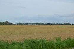
Fields along England Road, northwest of Fostoria | |
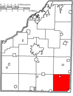 Location of Perry Township in Wood County | |
| Coordinates: 41°13′1″N 83°28′14″W / 41.21694°N 83.47056°WCoordinates: 41°13′1″N 83°28′14″W / 41.21694°N 83.47056°W | |
| Country | United States |
| State | Ohio |
| County | Wood |
| Area | |
| • Total | 35.2 sq mi (91.1 km2) |
| • Land | 35.2 sq mi (91.1 km2) |
| • Water | 0.0 sq mi (0.0 km2) |
| Elevation[1] | 728 ft (222 m) |
| Population (2010) | |
| • Total | 1,605 |
| • Density | 46/sq mi (18/km2) |
| Time zone | Eastern (EST) (UTC-5) |
| • Summer (DST) | EDT (UTC-4) |
| FIPS code | 39-62106[2] |
| GNIS feature ID | 1087192[1] |
Perry Township is one of the nineteen townships of Wood County, Ohio, United States. The 2010 census found 1,605 people in the township.[3]
Geography
Located in the southeastern corner of the county, it borders the following townships:
- Montgomery Township - north
- Scott Township, Sandusky County - northeast corner
- Jackson Township, Seneca County - east
- Loudon Township, Seneca County - southeast corner
- Washington Township, Hancock County - south
- Cass Township, Hancock County - southwest corner
- Bloom Township - west
- Portage Township - northwest corner
Part of the city of Fostoria is located in southeastern Perry Township, and the village of West Millgrove lies in the township's north.
Name and history
Perry Township was established in 1833.[4] It is one of twenty-six Perry Townships statewide.[5]
Government
The township is governed by a three-member board of trustees, who are elected in November of odd-numbered years to a four-year term beginning on the following January 1. Two are elected in the year after the presidential election and one is elected in the year before it. There is also an elected township fiscal officer,[6] who serves a four-year term beginning on April 1 of the year after the election, which is held in November of the year before the presidential election. Vacancies in the fiscal officership or on the board of trustees are filled by the remaining trustees.
References
- 1 2 "US Board on Geographic Names". United States Geological Survey. 2007-10-25. Retrieved 2008-01-31.
- ↑ "American FactFinder". United States Census Bureau. Retrieved 2008-01-31.
- ↑ "Geographic Identifiers: 2010 Demographic Profile Data (G001): Perry township, Wood County, Ohio". U.S. Census Bureau, American Factfinder. Retrieved January 22, 2013.
- ↑ "Cities, Townships, & Villages". Wood County Government. Archived from the original on June 6, 2015. Retrieved 11 January 2016.
- ↑ "Detailed map of Ohio" (PDF). United States Census Bureau. 2000. Retrieved 2007-02-16.
- ↑ §503.24, §505.01, and §507.01 of the Ohio Revised Code. Accessed 4/30/2009.
External links
Municipalities and communities of Wood County, Ohio, United States | ||
|---|---|---|
| Cities | 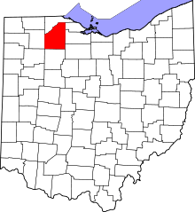 | |
| Villages | ||
| Townships | ||
| CDPs | ||
| Other unincorporated communities | ||
| Footnotes | ‡This populated place also has portions in an adjacent county or counties | |