Perth County, Ontario
- For the town in Lanark County, Ontario see Perth, Ontario.
| Perth County | ||
|---|---|---|
| County (upper-tier) | ||
| County of Perth | ||
| ||
 Location of Perth County | ||
| Coordinates: 43°30′N 81°05′W / 43.500°N 81.083°WCoordinates: 43°30′N 81°05′W / 43.500°N 81.083°W | ||
| Country |
| |
| Province |
| |
| Formed | 1850 | |
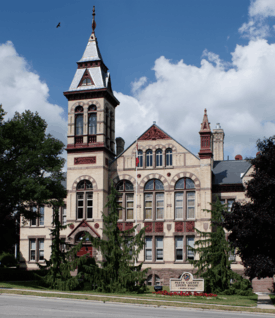
| County seat | Stratford | |
| Municipalities |
List
| |
| Area[1] | ||
| • Land | 2,179.03 km2 (841.33 sq mi) | |
| Elevation | 394 m (1,293 ft) | |
| Population (2011)[1] | ||
| • Total | 37,571 | |
| • Density | 17.2/km2 (45/sq mi) | |
| Time zone | EST (UTC−5) | |
| • Summer (DST) | EDT (UTC−4) | |
| Area code(s) | 519 and 226 | |
| Website | www.countyofperth.on.ca | |
Perth County is a county of the Canadian province of Ontario, and is located in Southwestern Ontario, 100 kilometres (62 mi) west of Toronto. The county seat is at Stratford, which is separated from the county but within its geographic boundary. According to the 2011 census, the population of Perth County was 37,571.
Subdivisions
The county includes:
- Municipality of North Perth
- Township of Perth East
- Township of Perth South
- Municipality of West Perth
The City of Stratford and Town of St. Marys are part of the Perth census division, but are separated from the county.
Historic townships
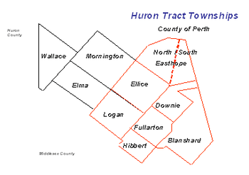
Perth County, area 524,571 acres (820 sq mi; 2,123 km2), was mainly settled through the agency of the Canada Company which opened a road from the site of Stratford to Goderich. It was officially created in January 1850 out of the former Huron and Wellington Districts and had 11 original townships:[2][3]
- Blanshard Township, area 45,952 acres (72 sq mi; 186 km2). Opened in 1830 and named from Richard Blanshard, Director of the Canada Company.
- Downie Township, area 48,342 acres (76 sq mi; 196 km2). The township was opened for settlement in 1830 and named in honour of Robert Downie, M.P., one of the directors of the Canada Company.
- Easthope Townships (North and South). Areas 43,117 and 23,641 acres (37 sq mi; 96 km2). Named from Sir John Easthope, M.P. A Director of the Canada Company. Opened for settlement in 1830. Until 1843 the townships were one.
- Ellice Township. Area 54,520 acres (85 sq mi; 221 km2). Opened in 1830 and named in honour of Rt. Hon. Edward Ellice, a Canadian-born director of the Canada Company. His father was managing director of the Hudson's Bay Company.
- Elma Township, Area 67,413 acres (105 sq mi; 273 km2). Opened in 1849; although the first settlers, Samuel Boyd and George Code, came from the east, Lanark County, in 1848. Named in honour of Lady Elma Bruce, daughter of James Bruce, 8th Earl of Elgin, Governor-general of Canada.
- Fullarton Township. Area 40,198 acres (63 sq mi; 163 km2). Opened in 1830 and named from John Fullarton, Director of the Canada Company.
- Hibbert Township. Area 41,421 acres (65 sq mi; 168 km2). Opened in 1830 and named in honour of William T. Hibbert, Director of the Canada Company. First settler was Thomas Fox who received 200 acres (0.8 km2) of land from the Company on the condition he open an inn for travelers on the Huron Road.
- Logan Township. Area 53,748 acres (84 sq mi; 218 km2). Opened for settlement in 1830. Named in honour of Hart Logan, Director of the Canada Company and uncle of Sir William E. Logan, the founder of the Canadian Geological Survey.
- Mornington Township Area 50,087 acres (78 sq mi; 203 km2). Opened for settlement in 1845 and surveyed in 1850. Named in honour of Richard Wellesley, Earl of Mornington, eldest brother of the Duke of Wellington.
- Wallace Township. Area 50,508 acres (79 sq mi; 204 km2). Opened for settlement in 1849 and named in honour of Thomas, Baron Wallace, Vice-president of the British Board of Trade under Lord Goderich in 1820.
- City of Stratford. In Downie, Ellice and Easthope Township. In 1831 William Sergeant was given a lot by the Canada Company on the condition that he open an inn. In 1832 he erected the first frame building in the region by the Avon River and called it the "Shakespeare Hotel." First purchaser of land was John Sharman (1834), a blacksmith from Bedfordshire, England. His son, Henry, was the first child born within the limits of the city.
Over time, four additional towns were incorporated as urban municipalities: St. Marys, Mitchell, Listowel and Milverton. On January 1, 1998, the county was restructured by reducing fourteen municipalities to four. Only the City of Stratford and the Town of St. Marys were unaffected.[3]
Demographics
Historic population:
- Population in 2011: 37,571 (5-year growth rate: 1.0%)
- Population in 2006: 37,212 (5-year growth rate: -1.0%)
- Population in 2001: 37,602 (5-year growth rate: 1.5%)
- Population in 1996: 37,147
Figures below are for the Perth census division, which combines Perth County, the City of Stratford and the Town of St. Marys.
| Canada census – Perth County, Ontario community profile | |||
|---|---|---|---|
| 2011 | 2006 | 2001 | |
| Population: | 75,112 (1.0% from 2006) | 74,344 (0.9% from 2001) | 73,675 (2.2% from 1996) |
| Land area: | 2,218.46 km2 (856.55 sq mi) | 2,218.41 km2 (856.53 sq mi) | 2,218.41 km2 (856.53 sq mi) |
| Population density: | 33.9/km2 (88/sq mi) | 33.5/km2 (87/sq mi) | 33.2/km2 (86/sq mi) |
| Median age: | 39.3 (M: 37.8, F: 40.7) | 37.2 (M: 35.9, F: 38.3) | |
| Total private dwellings: | 30,631 | 29,707 | 28,379 |
| Median household income: | |||
| References: 2011[4] 2006[5] 2001[6] | |||
Media
Newspapers
- SNAP Perth
- The Beacon Herald
- The Stratford Gazette
- The St. Marys Journal Argus
- The Listowel Banner
Radio
See also
References
- 1 2 "Perth County census profile". 2011 Census of Population. Statistics Canada. Retrieved 2012-03-26.
- ↑ Jesse Edgar Middleton & Fred Landon, Province of Ontario—A History 1615 to 1927, 1927, Dominion Publishing Company, Toronto
- 1 2 "About Perth County". County of Perth. Retrieved 2011-01-31.
- ↑ "2011 Community Profiles". Canada 2011 Census. Statistics Canada. July 5, 2013. Retrieved 2012-03-26.
- ↑ "2006 Community Profiles". Canada 2006 Census. Statistics Canada. March 30, 2011. Retrieved 2012-03-26.
- ↑ "2001 Community Profiles". Canada 2001 Census. Statistics Canada. February 17, 2012. Retrieved 2012-03-26.
External links
| Wikimedia Commons has media related to Perth County, Ontario. |
 |
Huron County | | ||
| Huron County | |
Wellington County Waterloo Regional Municipality | ||
| ||||
| | ||||
| Middlesex County | Oxford County |
| Regions | |
|---|---|
| Counties | |
| Districts | |
| Regional municipalities | |
| Single-tier municipalities | |
| Separated municipalities | |
| |