Phelps City, Missouri
| Phelps City, Missouri | |
|---|---|
| Census-designated place & unincorporated community | |
 Phelps City | |
| Coordinates: 40°24′12″N 95°35′55″W / 40.40333°N 95.59861°WCoordinates: 40°24′12″N 95°35′55″W / 40.40333°N 95.59861°W | |
| Country | United States |
| State | Missouri |
| County | Atchison |
| Area[1] | |
| • Total | 0.493 sq mi (1.28 km2) |
| • Land | 0.493 sq mi (1.28 km2) |
| • Water | 0 sq mi (0 km2) |
| Elevation | 892 ft (272 m) |
| Population (2010)[2] | |
| • Total | 24 |
| • Density | 49/sq mi (19/km2) |
| Time zone | Central (CST) (UTC-6) |
| • Summer (DST) | CDT (UTC-5) |
| Area code(s) | 660 |
| GNIS feature ID | 724280[3] |
Phelps City is a census-designated place and unincorporated community in Atchison County, Missouri. As of the 2010 census, its population was 24.[2] The community is 5 miles (8.0 km) west of Rock Port.[3] It is the closest Missouri community to Brownville Bridge, a Missouri River crossing that is listed on the National Register of Historic Places.
History
Phelps City was platted in 1868.[4] The community was named for Willis Phelps, one of the owners of the town site.[5] A post office was established at Phelps City in 1868, and remained in operation until 1954.[6]
References
- ↑ "US Gazetteer files: 2010, 2000, and 1990". United States Census Bureau. 2011-02-12. Retrieved 2011-04-23.
- 1 2 "American FactFinder". United States Census Bureau. Retrieved 2011-05-14.
- 1 2 "Phelps City". Geographic Names Information System. United States Geological Survey.
- ↑ "Atchison County Place Names, 1928-1945 (archived)". The State Historical Society of Missouri. Retrieved 30 August 2016.
- ↑ Eaton, David Wolfe (1916). How Missouri Counties, Towns and Streams Were Named. The State Historical Society of Missouri. p. 203.
- ↑ "Post Offices". Jim Forte Postal History. Retrieved 30 August 2016.
Municipalities and communities of Atchison County, Missouri, United States | ||
|---|---|---|
| Cities | 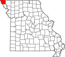 | |
| Village | ||
| Townships | ||
| CDPs | ||
| Unincorporated communities | ||
| Ghost towns | ||
This article is issued from Wikipedia - version of the 10/25/2016. The text is available under the Creative Commons Attribution/Share Alike but additional terms may apply for the media files.