Popponesset Island, Massachusetts
| Popponesset Island | |
|---|---|
| Census-designated place | |
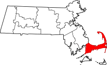
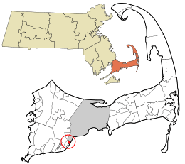 Location in Barnstable County and the state of Massachusetts. | |
| Coordinates: 41°35′8″N 70°27′32″W / 41.58556°N 70.45889°WCoordinates: 41°35′8″N 70°27′32″W / 41.58556°N 70.45889°W | |
| Country | United States |
| State | Massachusetts |
| County | Barnstable |
| Town | Mashpee |
| Area | |
| • Total | 0.38 sq mi (0.99 km2) |
| • Land | 0.07 sq mi (0.19 km2) |
| • Water | 0.31 sq mi (0.80 km2) |
| Elevation[1] | 0 ft (0 m) |
| Population (2010) | |
| • Total | 26 |
| • Density | 361/sq mi (139.5/km2) |
| Time zone | Eastern (EST) (UTC-5) |
| • Summer (DST) | EDT (UTC-4) |
| FIPS code | 25-55090 |
| GNIS feature ID | 2378206[1] |
Popponesset Island is a census-designated place (CDP) in the town of Mashpee in Barnstable County, Massachusetts, United States. The population was 26 at the 2010 census.[2]
Geography
Popponesset Island is located in the southeastern part of the town of Mashpee.[3] It lies in Popponesset Bay, an arm of Nantucket Sound, and is separated from the mainland of Cape Cod by the narrow Popponesset Creek. The CDP of New Seabury is to the west, across Popponesset Creek, and the Popponesset CDP is to the southwest. The town of Barnstable is to the northeast, across Popponesset Bay.
According to the United States Census Bureau, the Popponesset Island CDP has a total area of 0.39 square miles (1.0 km2). 0.077 square miles (0.2 km2) of it is land, and 0.31 square miles (0.8 km2) of it (81.16%) is water.[2]
History
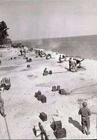
During World War II, Popponesset Island was used for amphibious assault training.
Demographics
As of the census[4] of 2000, there were 39 people, 19 households, and 12 families residing in the CDP. The population density was 188.2/km² (502.1/mi²). There were 69 housing units at an average density of 333.0/km² (888.3/mi²). The racial makeup of the CDP was 100.00% White.
There were 19 households out of which 15.8% had children under the age of 18 living with them, 57.9% were married couples living together, 5.3% had a female householder with no husband present, and 31.6% were non-families. 31.6% of all households were made up of individuals and 21.1% had someone living alone who was 65 years of age or older. The average household size was 2.05 and the average family size was 2.54.
In the CDP the population was spread out with 17.9% under the age of 18, 10.3% from 25 to 44, 35.9% from 45 to 64, and 35.9% who were 65 years of age or older. The median age was 58 years. For every 100 females there were 85.7 males. For every 100 females age 18 and over, there were 113.3 males.
The median income for a household in the CDP was $65,179; median incomes for families, males and females are unknown, due to the small size of the population. The per capita income for the CDP was $48,815. None of the population were below the poverty line.
References
- 1 2 U.S. Geological Survey Geographic Names Information System: Popponesset Island, Massachusetts
- 1 2 "Geographic Identifiers: 2010 Demographic Profile Data (G001): Popponesset Island CDP, Massachusetts". U.S. Census Bureau, American Factfinder. Retrieved December 11, 2013.
- ↑ "US Gazetteer files: 2010, 2000, and 1990". United States Census Bureau. 2011-02-12. Retrieved 2011-04-23.
- ↑ "American FactFinder". United States Census Bureau. Retrieved 2008-01-31.