Portage Historic District
|
Portage Historic District | |
|
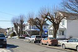
Houses on Gillespie at Cambria | |
  | |
| Location | Roughly bounded by N. Railroad Ave., Prospect St., Johnson Ave. and Vine St., Portage Township, Portage, Pennsylvania |
|---|---|
| Coordinates | 40°23′07″N 78°40′23″W / 40.38528°N 78.67306°WCoordinates: 40°23′07″N 78°40′23″W / 40.38528°N 78.67306°W |
| Area | 95 acres (38 ha) |
| NRHP Reference # | 95000890[1] |
| Added to NRHP | July 21, 1995 |
Portage Historic District is a national historic district located at Portage in Cambria County, Pennsylvania. The district includes 561 contributing buildings and 5 contributing structures (4 are bridges) in the central business district and surrounding residential areas of Portage. Most of the buildings were built between 1900 and 1925, with the oldest dated to the 1870s. Notable non-residential buildings include the Pennsylvania Railroad freight station (c. 1906), Pennsylvania Railroad passenger station (c. 1916), Palmer Feed Mill (c. 1916), Pearce Building (1914), Central Hotel (c. 1916), Century Ribbon Mill (1906-1911), Portage Bronze Electric Company (c. 1916), First Lutheran Church (1872), S. Michael's Orthodox Church (1915), and Hungarian Hall (c. 1920).[2]
It was listed on the National Register of Historic Places in 1995.[1]
References
- 1 2 National Park Service (2010-07-09). "National Register Information System". National Register of Historic Places. National Park Service.
- ↑ "National Historic Landmarks & National Register of Historic Places in Pennsylvania" (Searchable database). CRGIS: Cultural Resources Geographic Information System. Note: This includes Nancy L. Smith (April 1995). "National Register of Historic Places Inventory Nomination Form: Portage Historic District" (PDF). Retrieved 2011-12-08.
| Topics |   | |
|---|---|---|
| Lists by county |
| |
| Lists by city | ||
| Other lists | ||
| ||