Pottsgrove, Pennsylvania
| Pottsgrove | |
| Census-designated place | |
| Country | United States |
|---|---|
| State | Pennsylvania |
| County | Montgomery |
| Township | Lower Pottsgrove |
| Elevation | 256 ft (78.0 m) |
| Coordinates | 40°15′43″N 75°36′45″W / 40.26194°N 75.61250°WCoordinates: 40°15′43″N 75°36′45″W / 40.26194°N 75.61250°W |
| Area | 2.7 sq mi (7.0 km2) |
| - land | 2.7 sq mi (7 km2) |
| - water | 0.0 sq mi (0 km2), 0% |
| Population | 3,469 (2010) |
| Density | 1,284.8/sq mi (496.1/km2) |
| Timezone | EST (UTC-5) |
| - summer (DST) | EDT (UTC-4) |
| Area code | 610 |
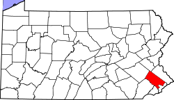
 Location of Pottsgrove in Pennsylvania | |
 Location of Pennsylvania in the United States | |
Pottsgrove is a census-designated place (CDP) in Montgomery County, Pennsylvania, United States. The population was 3,469 at the 2010 census.
Geography
Pottsgrove is located at 40°15′43″N 75°36′45″W / 40.26194°N 75.61250°W (40.261983, -75.612585).[1]
According to the United States Census Bureau, the CDP has a total area of 2.7 square miles (7.0 km2), all of it land.
Demographics
| Historical population | |||
|---|---|---|---|
| Census | Pop. | %± | |
| 1990 | 3,122 | — | |
| 2000 | 3,266 | 4.6% | |
| 2010 | 3,469 | 6.2% | |
As of the 2010 census, the CDP was 93.2% Non-Hispanic White, 3.1% Black or African American, 0.9% Asian, and 1.4% were two or more races. 1.8% of the population were of Hispanic or Latino ancestry.[2]
As of the census[3] of 2000, there were 3,266 people, 1,203 households, and 973 families residing in the CDP. The population density was 1,191.7 people per square mile (460.2/km2). There were 1,237 housing units at an average density of 451.4/sq mi (174.3/km2). The racial makeup of the CDP was 97.52% White, 0.89% African American, 0.03% Native American, 0.83% Asian, 0.03% Pacific Islander, 0.12% from other races, and 0.58% from two or more races. Hispanic or Latino of any race were 0.61% of the population.
There were 1,203 households, out of which 33.5% had children under the age of 18 living with them, 72.3% were married couples living together, 6.0% had a female householder with no husband present, and 19.1% were non-families. 15.5% of all households were made up of individuals, and 8.0% had someone living alone who was 65 years of age or older. The average household size was 2.71 and the average family size was 3.02.
In the CDP the population was spread out, with 24.7% under the age of 18, 5.0% from 18 to 24, 28.0% from 25 to 44, 28.3% from 45 to 64, and 14.0% who were 65 years of age or older. The median age was 41 years. For every 100 females there were 101.6 males. For every 100 females age 18 and over, there were 95.7 males.
The median income for a household in the CDP was $63,750, and the median income for a family was $68,578. Males had a median income of $45,920 versus $37,644 for females. The per capita income for the CDP was $30,649. About 1.0% of families and 2.0% of the population were below the poverty line, including 1.3% of those under age 18 and none of those age 65 or over.
Education
Pottsgrove is served by the Pottsgrove School District. Its high school is Pottsgrove High School.
References
- ↑ "US Gazetteer files: 2010, 2000, and 1990". United States Census Bureau. 2011-02-12. Retrieved 2011-04-23.
- ↑ Census 2010: Pennsylvania. Usatoday.Com. Retrieved on 2013-07-21.
- ↑ "American FactFinder". United States Census Bureau. Retrieved 2008-01-31.