Préfailles
| Préfailles | ||
|---|---|---|
|
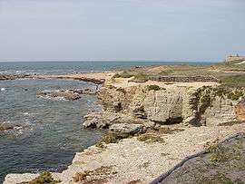
The landscape of Saint Gildas Point | ||
| ||
 Préfailles | ||
|
Location within Pays de la Loire region  Préfailles | ||
| Coordinates: 47°08′00″N 2°13′00″W / 47.1333°N 2.2167°WCoordinates: 47°08′00″N 2°13′00″W / 47.1333°N 2.2167°W | ||
| Country | France | |
| Region | Pays de la Loire | |
| Department | Loire-Atlantique | |
| Arrondissement | Saint-Nazaire | |
| Canton | Pornic | |
| Intercommunality | Pornic | |
| Government | ||
| • Mayor (2008–2014) | Jean-Luc Le Brigand (PR) | |
| Area1 | 4.72 km2 (1.82 sq mi) | |
| Population (2006)2 | 1,182 | |
| • Density | 250/km2 (650/sq mi) | |
| Time zone | CET (UTC+1) | |
| • Summer (DST) | CEST (UTC+2) | |
| INSEE/Postal code | 44136 / 44770 | |
| Elevation | 0–36 m (0–118 ft) | |
| Website | http://www.prefailles.fr/ | |
|
1 French Land Register data, which excludes lakes, ponds, glaciers > 1 km² (0.386 sq mi or 247 acres) and river estuaries. 2 Population without double counting: residents of multiple communes (e.g., students and military personnel) only counted once. | ||
.svg.png)
Préfailles is a commune in the Loire-Atlantique department in western France.
See also
| Wikimedia Commons has media related to Préfailles. |
This article is issued from Wikipedia - version of the 2/5/2015. The text is available under the Creative Commons Attribution/Share Alike but additional terms may apply for the media files.