Prescott, Kansas
| Prescott, Kansas | |
|---|---|
| City | |
 Location within Linn County and Kansas | |
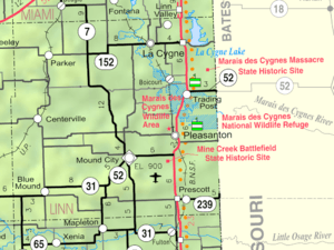 KDOT map of Linn County (legend) | |
| Coordinates: 38°3′47″N 94°41′47″W / 38.06306°N 94.69639°WCoordinates: 38°3′47″N 94°41′47″W / 38.06306°N 94.69639°W | |
| Country | United States |
| State | Kansas |
| County | Linn |
| Area[1] | |
| • Total | 0.28 sq mi (0.73 km2) |
| • Land | 0.26 sq mi (0.67 km2) |
| • Water | 0.02 sq mi (0.05 km2) |
| Elevation | 886 ft (270 m) |
| Population (2010)[2] | |
| • Total | 264 |
| • Estimate (2012[3]) | 259 |
| • Density | 1,015.4/sq mi (392.0/km2) |
| Time zone | Central (CST) (UTC-6) |
| • Summer (DST) | CDT (UTC-5) |
| ZIP code | 66767 |
| Area code(s) | 913 |
| FIPS code | 20-57650[4] |
| GNIS feature ID | 0478177[5] |
Prescott is a city in Linn County, Kansas, United States. As of the 2010 census, the city population was 264.[6]
History
Prescott was laid out in 1870. It was named for C. H. Prescott, a railroad official.[7]
Geography
Prescott is located at 38°3′47″N 94°41′47″W / 38.06306°N 94.69639°W (38.063063, -94.696339).[8] According to the United States Census Bureau, the city has a total area of 0.28 square miles (0.73 km2), of which, 0.26 square miles (0.67 km2) is land and 0.02 square miles (0.05 km2) is water.[1]
Demographics
| Historical population | |||
|---|---|---|---|
| Census | Pop. | %± | |
| 1880 | 151 | — | |
| 1890 | 241 | 59.6% | |
| 1900 | 298 | 23.7% | |
| 1910 | 255 | −14.4% | |
| 1920 | 291 | 14.1% | |
| 1930 | 238 | −18.2% | |
| 1940 | 277 | 16.4% | |
| 1950 | 283 | 2.2% | |
| 1960 | 278 | −1.8% | |
| 1970 | 222 | −20.1% | |
| 1980 | 319 | 43.7% | |
| 1990 | 301 | −5.6% | |
| 2000 | 280 | −7.0% | |
| 2010 | 264 | −5.7% | |
| Est. 2015 | 262 | [9] | −0.8% |
| U.S. Decennial Census | |||
2010 census
As of the census[2] of 2010, there were 264 people, 109 households, and 64 families residing in the city. The population density was 1,015.4 inhabitants per square mile (392.0/km2). There were 125 housing units at an average density of 480.8 per square mile (185.6/km2). The racial makeup of the city was 92.4% White, 0.8% African American, 2.3% Native American, 2.7% from other races, and 1.9% from two or more races. Hispanic or Latino of any race were 3.4% of the population.
There were 109 households of which 19.3% had children under the age of 18 living with them, 47.7% were married couples living together, 5.5% had a female householder with no husband present, 5.5% had a male householder with no wife present, and 41.3% were non-families. 36.7% of all households were made up of individuals and 15.6% had someone living alone who was 65 years of age or older. The average household size was 2.10 and the average family size was 2.66.
The median age in the city was 49.8 years. 17% of residents were under the age of 18; 5% were between the ages of 18 and 24; 20.1% were from 25 to 44; 28.3% were from 45 to 64; and 29.5% were 65 years of age or older. The gender makeup of the city was 49.2% male and 50.8% female.
2000 census
As of the census[4] of 2000, there were 280 people, 109 households, and 58 families residing in the city. The population density was 1,207.0 people per square mile (470.0/km²). There were 124 housing units at an average density of 534.5 per square mile (208.2/km²). The racial makeup of the city was 99.29% White, 0.36% Native American and 0.36% Asian. Hispanic or Latino of any race were 2.14% of the population.
There were 109 households out of which 22.0% had children under the age of 18 living with them, 41.3% were married couples living together, 11.0% had a female householder with no husband present, and 45.9% were non-families. 43.1% of all households were made up of individuals and 25.7% had someone living alone who was 65 years of age or older. The average household size was 2.03 and the average family size was 2.78.
In the city the population was spread out with 16.8% under the age of 18, 5.4% from 18 to 24, 17.9% from 25 to 44, 18.2% from 45 to 64, and 41.8% who were 65 years of age or older. The median age was 53 years. For every 100 females there were 77.2 males. For every 100 females age 18 and over, there were 72.6 males.
The median income for a household in the city was $23,462, and the median income for a family was $33,125. Males had a median income of $20,694 versus $31,875 for females. The per capita income for the city was $12,811. About 3.7% of families and 15.6% of the population were below the poverty line, including 11.8% of those under the age of eighteen and 16.9% of those sixty five or over.
References
- 1 2 "US Gazetteer files 2010". United States Census Bureau. Retrieved 2012-07-06.
- 1 2 "American FactFinder". United States Census Bureau. Retrieved 2012-07-06.
- ↑ "Population Estimates". United States Census Bureau. Retrieved 2013-05-29.
- 1 2 "American FactFinder". United States Census Bureau. Retrieved 2008-01-31.
- ↑ "US Board on Geographic Names". United States Geological Survey. 2007-10-25. Retrieved 2008-01-31.
- ↑ "2010 City Population and Housing Occupancy Status". U.S. Census Bureau. Retrieved April 13, 2011.
- ↑ Blackmar, Frank Wilson (1912). Kansas: A Cyclopedia of State History, Volume 2. Standard Publishing Company. p. 501.
- ↑ "US Gazetteer files: 2010, 2000, and 1990". United States Census Bureau. 2011-02-12. Retrieved 2011-04-23.
- ↑ "Annual Estimates of the Resident Population for Incorporated Places: April 1, 2010 to July 1, 2015". Retrieved July 2, 2016.
External links
| Wikimedia Commons has media related to Prescott, Kansas. |
- City
- Schools
- USD 346, local school district
- Maps
- Prescott City Map, KDOT
Municipalities and communities of Linn County, Kansas, United States | ||
|---|---|---|
| Cities | 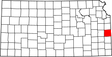 | |
| Unincorporated communities | ||
| Ghost town | ||