Purdum, Nebraska
| Purdum, Nebraska | |
|---|---|
| Unincorporated community | |
|
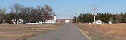
Purdum, seen from the south | |
 Purdum, Nebraska Location within the state of Nebraska | |
| Coordinates: 42°3′54″N 100°15′30″W / 42.06500°N 100.25833°WCoordinates: 42°3′54″N 100°15′30″W / 42.06500°N 100.25833°W | |
| Country | United States |
| State | Nebraska |
| County | Blaine |
| Area | |
| • Total | 27.161 sq mi (70.35 km2) |
| • Land | 26.969 sq mi (69.85 km2) |
| • Water | 0.192 sq mi (0.50 km2) |
| Elevation | 2,494 ft (760 m) |
| Population (2010) | |
| • Total | 21 |
| • Density | 0.77/sq mi (0.30/km2) |
| Time zone | Central (CST) (UTC-6) |
| • Summer (DST) | CDT (UTC-5) |
| ZIP codes | 69157 |
| Area code(s) | 308 |
| GNIS feature ID | 832414 |
Purdum is an unincorporated community in northwestern Blaine County, Nebraska, United States. It lies along local roads northwest of the village of Brewster, the county seat of Blaine County.[1] Its elevation is 2,700 feet (823 m).[2] Although Purdum is unincorporated, it has a post office, with the ZIP code of 69157.[3] The town is also home to the Purdum State Bank, and a half-dozen small businesses, a church, and a fire station. In the immediate environs are several livestock ranches.
History
Purdum was named for John Purdum, a pioneer settler.[4]
References
- ↑ Rand McNally. The Road Atlas '08. Chicago: Rand McNally, 2008, p. 62.
- ↑ U.S. Geological Survey Geographic Names Information System: Purdum, Nebraska, Geographic Names Information System, 1979-03-09. Accessed 2008-04-26.
- ↑ Zip Code Lookup
- ↑ Fitzpatrick, Lillian L. (1960). Nebraska Place-Names. University of Nebraska Press. p. 19.
Municipalities and communities of Blaine County, Nebraska, United States | ||
|---|---|---|
| Villages | ||
| Unincorporated communities | ||
| Footnotes | ‡This populated place also has portions in an adjacent county or counties | |
This article is issued from Wikipedia - version of the 10/19/2016. The text is available under the Creative Commons Attribution/Share Alike but additional terms may apply for the media files.