New York and Putnam Railroad
 | |
| Reporting mark | NYP |
|---|---|
| Locale | The Bronx, Westchester and Putnam Counties, New York |
| Dates of operation | 1881–1913 |
| Successor | New York Central Railroad |
| Track gauge | 4 ft 8 1⁄2 in (1,435 mm) |
Legend
| ||||||||||||||||||||||||||||||||||||||||||||||||||||||||||||||||||||||||||||||||||||||||||||||||||||||||||||||||||||||||||||||||||||||||||||||||||||||||||||||||||||||||||||||||||||||||||||||||||||||||||||||||||||||||||||||||||||||||||||||||||||||||||||||||||||||||||||||||||||||||||||||||||||||||||||||||||||||||||||||||||||||||||||||||||||||||||||||||||||
The New York and Putnam Railroad (a.k.a. Old Put) was a railroad line that operated between The Bronx and Brewster, New York. It was in close proximity to Hudson River Railroad and New York & Harlem Railroad. All three came under ownership of the New York Central system in 1894. Abandonment began in 1958; most of the former roadbed has been converted for rail trail use.
History
Early years, charter
The New York & Boston Railroad (NY&B) was chartered May 21, 1869 to build a line from High Bridge on the Harlem River in New York northeast to Brewster. At Brewster connections were to be provided to the New York & Harlem Railroad for travel north to Albany, and to the Boston, Hartford & Erie Railroad to Boston.
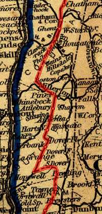
The New York, Boston & Northern Railway (NYB&N) was formed on November 18, 1872 as a consolidation of the NY&B with two companies to the north — the Putnam & Dutchess Railroad (P&D) and Dutchess & Columbia Railroad (D&C). The P&D was a plan for a line to split from the New York and Boston at Carmel to a point midway along the D&C. The D&C opened in 1871, running from the Hudson River to the Connecticut border. The Clove Branch Railroad was to serve as a short connection between the two parts of the planned line.
The New York, Boston & Montreal Railway was organized January 21, 1873 as a renaming of the NYB&N. It continued north to Chatham and then use the Harlem Extension Railroad into Vermont. The Panic of 1873 caused the cancellation of the leases and mergers on December 1 of that year. Construction on the P&D and D&C stopped; D&C later became part of the Central New England Railway, the Harlem Extension became a part of the Rutland Railroad, and the Clove Branch Railroad was abandoned in 1898.
The New York, Westchester & Putnam Railway was formed on July 3, 1877 as a reorganization, and was leased to the New York City & Northern Railroad (NYC&N), formed on March 1, 1878. Between East View and Pocantico Hills, the NYC&N built a segment leading to a perilous 80 foot high trestle over a marsh-filled valley.[1] Because of the dangers of crossing the bridge, which often required that trains slow down to a crawl, the line was rerouted west around that valley in 1881. The bridge was torn down in 1883, and the valley became the Tarrytown Reservoir.[2] The line finally opened under the original plan, ending at Brewster, in April 1881. That year, the New York & New England Railroad opened to the north, using some of the grade built for the P&D and D&C. The West Side & Yonkers Railway was leased to the NYC&N on May 1, 1880, extending the line south across the Harlem River to the northern terminal of the Ninth Avenue Elevated at 155th Street. It was merged into the NYC&N by 1887. In the 1910s, the Interborough Rapid Transit Company of the New York City subway (IRT) purchased that section its elevated lines north into the Bronx, cutting the NYP back to Sedgwick Avenue. The Yonkers Rapid Transit Railway was opened in 1888 as a branch from the NYP at Van Cortlandt northwest to Yonkers. It was merged into NYP by 1887.
Reorganization and decline
The company went into receivership by 1887 and was reorganized as the New York & Northern Railway. By 1894 it was reorganized as the New York & Putnam Railroad (NY&P) by J. P. Morgan who in turned leased the railroad to the New York Central & Hudson River Railroad (NYC&HR). The line eventually became the Putnam Division of the New York Central Railroad (NYC) by 1913. The line lacked a direct connection to NYC's flagship station, Grand Central Terminal (GCT), which hurt ridership throughout its existence. Passengers were forced to transfer at High Bridge to reach GCT. The Sedgwick Avenue-Van Cortlandt section and the Yonkers Branch were electrified in 1926.
Several short branches were eliminated after the 1920s. The Mohansic Branch near Yorktown Heights, originally built to serve a mental institution that was cancelled by Albany, went first. In 1929, John D. Rockefeller, Jr. had the tracks removed from his Pocantico Hills property, eliminating four stations while creating one. The nearby village of East View was obliterated to build the new line. The Getty Square branch was abandoned on June 30, 1943.[3] Despite a legal battle by Yonkers residents which reached the United States Supreme Court to save it, the line was scrapped in December 1944.[4][5]
The first diesel locomotive passenger train in the U.S. ran on the Putnam on March 18, 1929.
Besides the regular Sedgwick Avenue–Brewster service, service also operated from Golden's Bridge on the Harlem Division via a connecting branch to Lake Mahopac, and then over the Putnam Division to Brewster, where it returned to the Harlem Division. Trains taking this route were said to go "around the horn".
NYC saw the Putnam Division as a dispensable stepchild. The line lacked a second track, electrification, commuter parking and direct service to GCT, all of which the parallel Harlem and Hudson divisions had, resulting in steady patronage. NYC ended passenger service on the Putnam on May 29, 1958.[6] Service "around the horn" via the Harlem Division's Lake Mahopac Branch continued until April 2, 1959. Until 1962, when NYC's West Shore Railroad was upgraded, the Putnam served oversize freight trains, due to the lack of tunnels on the line. Tracks between East View and Lake Mahopac were removed in 1962.
NYC merged with long-time rival Pennsylvania Railroad to form Penn Central (PC) in 1968. Freight service on the northern part of the Putnam ended by 1970. The southern end of the line remained in service until the closing of the A&P warehouse in Elmsford in 1975. The decrease in traffic from Stauffer Chemical cut back the line to Chauncey by 1977. Conrail took over the bankrupt PC in April 1976, but had no plans for increasing business. Aside from businesses in Chauncey, the only customer was the Stella D'Oro bakery in the Bronx.
Legacy
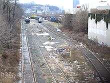
The Metro-North Railroad currently uses the remaining stub at Marble Hill for storage of maintenance of way and contractor's trains. The roadbed north of the former Van Cortlandt station has been converted into the South County Trailway, North County Trailway, and Putnam County Trailway rail trails.
A replica of the former Bryn Mawr Park station at the former Palmer Road grade crossing is in use as a grocery. The station in Briarcliff Manor was purchased by the village in 1959 and converted into the Briarcliff Manor Public Library.[7] The station in Elmsford serves as a restaurant. The Yorktown Heights station had its exterior restored and is the centerpiece of the town park. The station in Lake Mahopac has been an American Legion Hall since 1965.[8] The freight house in Baldwin Place and the station in Tilly Foster are on private property.
The Getty Square Branch still shows evidence of its existence, with vestiges of the railroad and stations, and neighborhoods exhibiting characteristics of transit-oriented development.[9] Getty Square station, originally a head house and train shed, was replaced by an office building, which still stands and is ornamented on its exterior and in its lobby with images of locomotives. The bridge in Van Cortlandt Park that carried the branch over the Henry Hudson Parkway is now a multi-use park path.
Abutments of the former branch can be found at School Street across from Herriott Street, McLean Avenue near South Broadway, and the former Lowerre Station on Lawrence Street at Western Avenue. The former Caryl Station on Caryl Avenue between Saratoga and Van Cortlandt Park Avenues, with the tunnel into Van Cortlandt Park walled off by cinder blocks is now the Caryl parking lot and playground.[10]
Private homes that once served the branch include the termini houses of the Park Hill station's adjacent funicular on Undercliff at Park Hill Terrace,[11] and on Alta Avenue[12] north of Overcliff, and the home of the railroad's president also on Alta Avenue.
Image gallery
 Skeletal remains of Van Cortlandt station
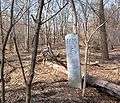 Milepost 6 located in Van Cortland Park; former railbed on left
 Bryn Mawr Park Station replica in 2007
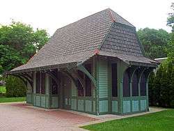 Yorktown Heights station, listed on National Register of Historic Places
 Getty Square Terminus Station Building, 20 South Broadway, Yonkers, NY
.png) The Briarcliff Manor station, now part of the village library
The Briarcliff Manor station, now part of the village library
Station listing
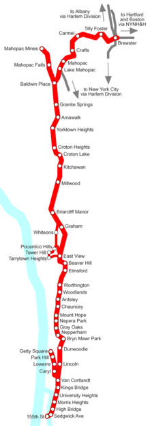
Main Line
NOTE: Stations along pre-1918 Manhattan terminus and pre-1931 Tarrytown Heights alignment are shaded in darker gray.
| Locality | Milepost | Station | Lat/long | Notes/Connections | |||
|---|---|---|---|---|---|---|---|
| Manhattan | 155th Street Terminal | Original terminal from 1881 to 1918. | |||||
| Putnam Bridge across the Harlem River shared by IRT Ninth Avenue Line until 1918 | |||||||
| The Bronx | 0.0 | Sedgwick Avenue | 40°49′53.12″N 73°55′56.15″W / 40.8314222°N 73.9322639°W | NYC Transit: Connected to former IRT Ninth Avenue Line station and West Side/High Line | |||
| Highbridge | 40°50′17.5″N 73°55′53″W / 40.838194°N 73.93139°W | Highbridge Maintenance Facility. Metro-North employees only. | |||||
| Morris Heights | 40°51′14.4″N 73°55′11.64″W / 40.854000°N 73.9199000°W | ||||||
| University Heights | 40°51′41.04″N 73°54′52.92″W / 40.8614000°N 73.9147000°W | ||||||
| Fordham Heights | Merged with University Heights Station in early 20th Century | ||||||
| Hudson & Putnam Lines split | |||||||
| Kings Bridge | Somewhere between 225th Street and 231st Street | ||||||
| 4.82 | Van Cortlandt | 40°53′28.185″N 73°53′31.649″W / 40.89116250°N 73.89212472°W | Inside Van Cortlandt Park | ||||
| Junction with electrified Getty Square Branch | |||||||
| Westchester | 6.52 | Lincoln | at McLean Avenue | ||||
| 8.09 | Dunwoodie | At Yonkers Avenue east of Dunwoodie Golf Course | |||||
| 9.44 | Bryn Mawr Park | 40°56.6905′0″N 73°51.4825′0″W / 40.94484°N 73.85804°W | Replaced in 1995 by Palmer/Bryn Mawr Market | ||||
| 10.50 | Nepperhan | ||||||
| 11.92 | Gray Oaks | ||||||
| 12.01 | Nepera Park | ||||||
| 13.02 | Mount Hope | ||||||
| 13.86 | Chauncey | 41°00′08″N 73°49′08″W / 41.00222°N 73.81889°W | |||||
| 14.72 | Ardsley | Off NY 9A between Saw Mill River Parkway and New York State Thruway. | |||||
| Woodlands | Small wooden platform and opened shelter with canopy. | ||||||
| 16.60 | Worthington | ||||||
| 18.14 | Elmsford | 41°03′16″N 73°49′14″W / 41.05444°N 73.82056°W | Currently a restaurant | ||||
| Beaver Hill | Wooden shelter designed as a flag stop for former Fairview Golf Club | ||||||
| Original alignment from short-lived 80-foot high Eastview Trestle segment began here (1880-1881). | |||||||
| 20.41 | Eastview | 41°04′50″N 73°45′45″W / 41.08056°N 73.76250°W | Original pre-1929 relocation line began here. | ||||
| Tarrytown Heights | Built March 1882; First station along Tarrytown Heights alignment west of East View station and original NY&P alignment | ||||||
| Tower Hill | Built November 26, 1881; Second station on former alignment west of Tarrytown Reservoir existed here until 1931 | ||||||
| Pocantico Hills | Built November 26, 1881; Third station along former alignment near Rockefeller Estate and Tarrytown Reservoir existed here until 1931 | ||||||
| Original alignment from short-lived 80-foot high Eastview Trestle segment ended here (1880-1881). | |||||||
| Whiteons | Fourth station along previous alignment. Replaced in 1931 by Graham station on new alignment | ||||||
| 23.92 | Graham | Created by 1931 relocation, Original pre-1929 alignment ended just north of here. Open shelter that was proposed for major expansion which never occurred. | |||||
| 27.04 | Briarcliff Manor | 41°08′48″N 73°49′28″W / 41.14667°N 73.82444°W | Currently the Briarcliff Manor Public Library. | ||||
| 30.44 | Millwood | 41°11′24.3126″N 73°47′48.9942″W / 41.190086833°N 73.796942833°W | |||||
| 32.52 | Kitchawan | ||||||
| 33.57 | Croton Lake | ||||||
| 35.04 | Croton Heights | ||||||
| 36.76 | Yorktown Heights | 41°16′17.5″N 73°46′47″W / 41.271528°N 73.77972°W | At Railroad Park on the National Register of Historic Places. Originally contained a coach yard and an engine service facility. | ||||
| Connection to Mohansic Branch | |||||||
| 37.94 | Amawalk | ||||||
| 39.96 | Granite Springs | ||||||
| Putnam | 42.25 | Baldwin Place | 41°20′43″N 73°45′16″W / 41.34535°N 73.75453°W | ||||
| Connection to Mahopac Mines branch | |||||||
| 44.38 | Lake Mahopac | Currently an American Legion Hall | |||||
| Connection to Lake Mahopac branch and Lincolndale and Katonah Stations | |||||||
| 45.13 | Mahopac | ||||||
| 47.20 | Crafts | ||||||
| 49.58 | Carmel | Southern terminus of unbuilt Putnam & Dutchess Railroad. | |||||
| 51.84 | Tilly Foster | Originally built for the Tilly Foster Mine, which closed in 1897. Station continued to operate. | |||||
| 53.82 | Putnam Junction | Not a station, connection with Harlem Division and Brewster Yard; included bridge to Beacon Line (a.k.a. CNE Highland Division) until 1907.[13] | |||||
| Brewster | 41°23′40.92″N 73°37′11.28″W / 41.3947000°N 73.6198000°W | ||||||
| Line continues along NYC's Harlem Division | |||||||
Branches
Getty Square Branch
| Locality | Milepost | Station | Lat/long | Notes/Connections | ||||
|---|---|---|---|---|---|---|---|---|
| The Bronx | 0.0 | Van Cortlandt | 40°53′28.185″N 73°53′31.649″W / 40.89116250°N 73.89212472°W | Beginning of Getty Square Branch | ||||
| Puntam & Getty Square Branches split | ||||||||
| Mosholu | Abandoned 1926 | |||||||
| Yonkers | Caryl | North of Caryl Avenue Bridge, which still exists today. | ||||||
| Lowerre | South of Lawrence Street between Western and Van Cortlandt Park Avenues. | |||||||
| 3.0 | Park Hill | Connected to former Park Hill Incline funicular railroad | ||||||
| 3.2? | Getty Square | |||||||
| Line abandoned in 1943 | ||||||||
Mohansic Branch
| Locality | Milepost | Station | Lat/long | Notes/Connections | |||
|---|---|---|---|---|---|---|---|
| Westchester | 0.0 | Yorktown Heights | 41°16′17.5″N 73°46′47″W / 41.271528°N 73.77972°W | ||||
| Putnam Line & Mohansic Branch split | |||||||
| Mohansic State Hospital | |||||||
| Line abandoned in 1917 | |||||||
Mahopac Mines Branch
| Locality | Milepost | Station | Lat/long | Notes/Connections | |||
|---|---|---|---|---|---|---|---|
| Putnam | 0.0 | Baldwin Place | 41°20′43″N 73°45′16″W / 41.34535°N 73.75453°W | ||||
| Putnam & Mahopac Mines Lines split | |||||||
| Mahopac Falls | |||||||
| 4.0 | Mahopac Mines | ||||||
| Line abandoned in 1931 | |||||||
See also
References
- ↑ "Tarry Town Trestle" (New York Public Library: Digital Archive)
- ↑ The Eastview Trestle (Archive Sleuth)
- ↑ "Getty Square Line Ends; 12 Riders on Last Trip". The New York Times. July 1, 1943. p. 21. Retrieved 2011-07-04.
- ↑ "High Court Lets Road Drop Getty Sq. Line". The New York Times. November 14, 1944. Retrieved 2011-07-04.
- ↑ "Putnam Line Being Razed". The New York Times. December 9, 1944. p. 30. Retrieved 2011-07-04.
- ↑ Folsom, Merrill (May 30, 1958). "The Wheels of 'Old Put' Click Out a Sad Accompaniment to Riders' 'Auld Lang Syne'". New York Times. p. 23. Retrieved 2011-07-04.
- ↑ Library History (Briarcliff Manor Public Library)
- ↑ The American Legion Mahopac Post 1080
- ↑ Klein, Daniel A. (2004). "The Phantom Spur Retracing the Vanished Getty Square Branch of the Putnam Railroad". National Railway Bulletin. 69 (2): 28–37.
- ↑ Caryl Lot (Yonker Parking Authority)
- ↑ Park Hill Lower Station; 1999 Bill Kessler Photograph (Existing stations in Westchester County, New York)
- ↑ Park Hill Upper Station; 2000 Walter Hahn Photograph (Existing stations in Westchester County, New York)
- ↑ Grogan, Louis V. (1989). The Coming of the New York and Harlem Railroad. Self-Published. p. 154. ISBN 0-962120- 65-0.
Further reading
- Carmel Town Historian; Putnam County Historian's Office (2010). "A Guide to the "Old Put" for Bikers and Hikers" (PDF). Putnam County Online. Archived (PDF) from the original on 29 June 2016.
- Gallo, Daniel R.; Kramer, Frederick A. (1981). The Putnam Division: New York Central's Bygone Route through Westchester County. New York: Quadrant Press. ISBN 0-915276-29-1.
- Kelley, Ed (2005). "'The Old Put' Suburban New York's Lost Railroad". Archived from the original on 14 September 2005.
- Vondrak, Otto M.; Bang, Robert A.; Kowanski, George W.; Frank, John (2008). Forgotten Railroads Through Westchester County. Port Chester, NY: Robert A. Bang. ISBN 978-0-9762797-3-0.
- Klein, Daniel A. (2004). "The Phantom Spur Retracing the Vanished Getty Square Branch of the Putnam Railroad". National Railway Bulletin. 69 (2): 28–37.
External links
- Timeline of Putnam Division events
- Stations along the trail on the Putnam Division Right-Of-Way]
- Putnam County Existing Stations: has pictures of old Put stations.
- Westchester County Existing Stations: has pictures of old Put stations.
| East of Hudson |  | |
|---|---|---|
| West of Hudson (operated by NJ Transit) | ||
| Non-revenue and Predecessor lines | ||
| Other | ||