Qu'Appelle, Saskatchewan
| Qu'Appelle Troy, Qu'Appelle Station, South Qu'Appelle | |
|---|---|
| Town | |
|
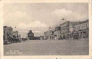
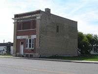
Main Street, Qu'Appelle, 2008. | |
 Qu'Appelle | |
| Coordinates: 50°32′28″N 103°52′26″W / 50.541°N 103.874°W | |
| Country | Canada |
| Province | Saskatchewan |
| Region | Saskatchewan |
| Census division | 6 |
| Rural Municipality | South Qu'appelle |
| Post office Founded | 1882 |
| Incorporated (Village) | N/A |
| Incorporated (Town) | February 20, 1903 |
| Government | |
| • Mayor | Tom Williamson |
| • Town Manager | Carol Wickenheiser |
| • Governing body | Qu'Appelle Town Council |
| Area | |
| • Total | 4.22 km2 (1.63 sq mi) |
| Elevation | 662.90 m (2,174.87 ft) |
| Population (2011) | |
| • Total | 668 |
| • Density | 158.1/km2 (409/sq mi) |
| Time zone | CST |
| Postal code | S0G 4A0 |
| Area code(s) | 306 |
| Highways | Highway 1, Highway 35 |
| Website | Town of Qu'Appelle |

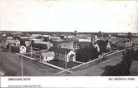
Qu'Appelle is a town in Saskatchewan, located on Highway 35 approximately 50 kilometres (31 mi) east of the provincial capital of Regina.
Qu'Appelle was for a time the terminus of the Canadian Pacific Railway and the major distribution centre for what was then the District of Assiniboia in the North-West Territories and is now southern Saskatchewan. The town is situated in a lush rolling parkland, with intermittent coulees containing steady-flowing creeks running into the Qu'Appelle Valley, poplar bluffs and sloughs.
Qu'Appelle had at one stage been credibly anticipated to be the major metropole of the North-West Territories by both the federal government and the Church of England (since 1955 the Anglican Church of Canada). It was under serious consideration by the federal government as district headquarters of the District of Assiniboia and territorial headquarters of the North-West Territories. The Church of England had in anticipation of Qu'Appelle's future urban importance designated it the cathedral city for the Diocese of Qu'Appelle, which geographically corresponded precisely to the District of Assiniboia in the North-West Territories.[1]
Political events, however, passed Qu'Appelle entirely by when Lieutenant-Governor Edgar Dewdney selected the locale of his own landholdings at Pile-O-Bones (then renamed "Regina" by Princess Louise, daughter of Queen Victoria, when her husband John Campbell, Marquess of Lorne was Governor General) as his Territorial capital: Qu'Appelle's significance other than in historical terms then largely lapsed.
Name

The CPR arrived in 1882-83,[2] and the post office was founded at what was originally called Troy on August 1, 1882.[3] For a time Qu'Appelle appeared likely to be the administrative headquarters for the District of Assiniboia, which corresponded to the southern portion of the present day province of Saskatchewan.
Two versions of the origin of the name "Troy" are proposed: That
(1) it was named after Troy, Ontario by Wellington Mulholland, a land surveyor and land agent[4] and
(2) the name was chosen by the brothers Stephen and James Caswell who were merchants in the area and managed the post office.
Original settlers hung onto the old name of "Troy" well into the 20th century.
When the Canadian Pacific Railway arrived in 1884 the new town was renamed Qu'Appelle Station in reference to the nearby Qu'Appelle Valley, which was the location of a long-established Hudson's Bay Company factory.[5] The name "Qu'Appelle," a corruption of qui appelle, French for "Who calls?" refers to the once-popular legend of the Qu'Appelle Valley versified by E. Pauline Johnson:
I am the one who loved her as my life,/Had watched her grow to sweet young womanhood;/ Won the dear privilege to call her wife,/ And found the world, because of her, was good./ I am the one who heard the spirit voice,/ Of which the paleface settlers love to tell;/ From whose strange story they have made their choice/ Of naming this fair valley the 'Qu'Appelle....'//[6]
In 1902 the name was changed to South Qu'Appelle[3] and in 1911 the longstanding confusion as to the name "Qu'Appelle," which also referred to the former Hudson's Bay Company fort town in the Qu'Appelle Valley, to the northeast of Qu'Appelle, was resolved when the two communities agreed to deem the then-CPR station site as Qu'Appelle and the town in the valley as Fort Qu'Appelle.[7]
History
Establishment
Like many small Canadian prairie towns, Qu'Appelle has had a considerably livelier past than its present. A Hudson's Bay Company trading post temporarily stood southwest of the future site of the town from 1854 through 1864[8][9] when it was re-located back to its previous site, the modern Fort Qu'Appelle in the Qu'Appelle Valley.[10]
Qu'Appelle was at one point among the likely choices as capital of the North-West Territories, as indicated by its original status as the historical see city of the Church of England in Canada (Anglican since 1955) Diocese of Qu'Appelle.[11] The choice of Pile-of-Bones, as Regina was originally called, as the Territorial headquarters was a national scandal in the 1880s: there was an "obvious conflict of interest" in Lieutenant-Governor Edgar Dewdney's promoting of Pile-of-Bones as the territorial headquarters[12] though not to the extent of preventing a major street in Regina being named "Dewdney Avenue" or is resuming his political career in British Columbia after leaving office in the North-West Territories in 1888.
A 1980 local town history reports that
In his January 5, 1892 edition of the Regina Leader, Nicholas Flood Davin explained what in his mind, and in the minds of most of the people in this area, was the real reason Qu'Appelle was not chosen, or rather why Pile of Bones was Dewdney's choice. According to Mr. Davin, Lieutenant-Governor Dewdney and fourteen other men formed a syndicate and bought Hudson Bay section along the C.P.R. Mainline....He chose the town site of Regina...about a mile (1.6 km) west of the present station—that is, on their own section '26'.[13]:[2, 11]
Until 1897, however, when responsible government was accomplished in the Territories,[14] the lieutenant-governor and council governed by fiat and there was little legitimate means of challenging such decisions outside the federal capital of Ottawa, where the Territories were remote and of little concern.

North-West Rebellion
Despite its loss of initial prominence as a likely territorial headquarters Qu'Appelle attained national prominence in 1885 during the North-West Rebellion. Until the construction of the Qu’Appelle, Long Lake, and Saskatchewan Railway in 1890 linked the newly established Regina with Saskatoon and Prince Albert, Qu'Appelle was the major debarkation and distribution centre for the North-West Territories.[15]
General Frederick Dobson Middleton, who billeted in Qu'Appelle's Queen's Hotel (which survived into the 21st century), made Qu'Appelle the marshalling point to the locus of the North-West Rebellion (the Saskatchewan or Second Riel Rebellion) in the north-west for troops arriving by train from eastern Canada.
.jpg)
For some years Qu'Appelle was the centre of national attention as journalists based there reported back home to eastern Canada on developments in the Saskatchewan Rebellion.[7] Qu'Appelle's significance in the 1880s before the anticipated prominence of it and Fort Qu'Appelle was substantially reduced by Lieutenant-Governor Dewdney's preference for Buffalo Bones — in the case of Qu'Appelle ultimately virtually eliminated — is even today in the Canadian Encyclopedia indicated by a simple reference to it: "General Middleton's original plan was simple. He wanted to march all his troops north from the railhead at Qu'Appelle to Batoche."[16] The resolution of the Saskatchewan Rebellion perhaps needless to say did not comprehensively resolve conflicts among settlers and aboriginal people. Many Qu'Appelle children of the late 19th and early 20th centuries recounted frightening encounters with angry Cree and Métis, who not unreasonably bore a considerable grudge against white settlers in the Qu'Appelle region.[13]:[15][17]
Early town life and economy
From 1882, early residents of Qu'Appelle included numerous English remittance men whose cultured backgrounds contributed significantly to the life of the town. Amateur theatricals and musical evenings were a regular feature of winter social life and it was important to early Qu'Appelle residents that there be an "opera house": an auditorium in the town hall.
"[T]he great influx of settlers into the District of Assiniboia in the early 1900s meant continued growth. The population of the community was 434 in 1901, but by the end of the first decade of the 20th century, it was near 1,000"[18]
At a time when farmers were vastly greater in number than later: a standard farm was 1/4 section, a section being one square mile, 640 acres. As in Fort Qu'Appelle, town life in many ways resembled that of an Indian hill station during the British Raj. Perhaps improbably in so small a community but indicative of the not always tolerant and inclusive social mores of early settlement in the Canadian west, discrete neighbourhoods of Qu'Appelle were called "Germantown" and "Breedville," the latter in racist early reference to the prairie Anglo-Métis, whom white settlers at the time called "half-breeds," a term now considered disparaging, and generally avoided.[19][20]
Relations between the English immigrants of the Anglican pro-cathedral parish and the native-born Canadian Presbyterian, Methodist and Roman Catholic settlers from Ontario and Quebec were at times frosty and the Anglican Church was long referred to in some disparagement as "the English Church" by eastern Canadian settlers who perhaps regarded themselves as more authentically Canadian. At one point Bishop Harding, the Church of England (Anglican) bishop, was quoted at a meeting — when he was imprudently unaware that local Canadians were hearing his remarks — as observing that English Anglican migrants might be more attractive settlers than Presbyterian and Methodist Canadians, occasioning considerable adverse notice and animosity against the English in the general community.[21]
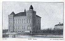

The fine yellow brick town hall and "opera house" remains marginally in use, though its auditorium has long since been closed to public use because it falls short of modern standards of safety and the town cannot bring it up.[22] Its companion building, Qu'Appelle High School, built in similar style in identical yellow brick, closed in 1973 and was demolished in 1975. The Queen's Hotel, built in 1884 (early on with the competitor of Smiths Hotel, far more briefly surviving) continued to operate, latterly largely as a town pub albeit that alcohol was briefly banned for drink in Saskatchewan after World War I, as vastly more lengthily in the USA. After steady commercial decline for many years it was destroyed by fire in 2003.

The first Qu'Appelle businesses of 1882 were a restaurant operated by J. Stoddard; pool hall by Love & Raymond; livery and feed store by Johnston & Paterson; livery and feed store by Joe Doolittle; and harness shop by John Milliken.[23] An observatory was opened in 1882 by Leslie Gordon and provided morning and evening weather readings for the CPR until 1907, when the observatory was supplemented with anemometer and weather recording devices.[13]:[42][24] The Qu'Appelle Felt and Boot factory opened at the end of 1897 but liquidated in 1900.[13]:[49] A fire in 1883 destroyed much of the new business district but soon there were six stores, three hotels, five implement agencies, two butcher shops, a flour and feed store and a bakery.[25]
Well into the 20th century there was still a train station, some half-dozen grain elevators, a bank, post office, butcher, two general stores, a hardware store, pharmacy, the hotel — "the Queen’s Hotel, which officially opened in 1884, was lost in an early morning blaze on April 16, 2003"[26] — (and "beverage room," in the terminology of the early 20th-century Canadian West, though closed from 1915 to 1925 under Premier Walter Scott's prohibition and temperance legislation[27]), barber shop, firehall, law office, numerous service stations, several cafés, cinema (later converted to a grocery store) and a covered rink.[28] In the 1890s, there was "a flour mill, a creamery [and] a felt and boot factory."[7]
The Qu'Appelle Anglican Diocese maintained the St John's College Farm immediately to the west of town.[29] By 1910 the town's population had risen to nearly 1,000.[7] Qu'Appelle was an important local business, shopping and distribution centre which staged an annual summer fair.[30]
Early surrounding farm community

Unlike in parts of the North-West Territories and, then, Province of Saskatchewan settled by Eastern Europeans in the Laurier-Sifton migration of the last decade of the 19th century and first decade of the 20th, much of the settlement in the Qu'Appelle District was by well-capitalised eastern Canadians and Britons. Rather than the small sod and plain lumber houses and outbuildings of later homesteaders, farm as well as town residential and outbuilding construction here was frequently large, ostentatious and built of brick or stone, often with large formal gardens, indicating not only the large families of the time but the anticipation of considerable prosperity and the ability to employ domestic help.

Town amenities of the early decades of settlement were contingent on the farming hinterland being far more densely populated than today; travel to Regina was accomplished via a train journey and domestic transport mostly by horse-drawn conveyances. With the vastly depleted rural population and improved transport these amenities have almost wholly lapsed. The rationalisation by the grain companies of their depots for buying grain from farmers and the resulting disappearance of Qu'Appelle's grain elevators hastened the process of decline as even the regular visits by farmers to town to deliver grain ceased.
Settlement colonies
As with the nearby large farming projects Bell Farm and Cannington Manor, there were also large farming ventures near Qu'Appelle. W. Thistle and Thomas Wright started the Wright farm in 1882 on four sections of land (one section having been one one square mile or 2.6 km2, 640 acres or 260 hectares). By 1884, there were 770 acres (310 ha) in crops and 1,050 acres (420 ha) tilled and ready for seed.
In 1884, the Wrights...owned a steam threshing machine four binders, twelve teams of horses, four yokes of oxen, forty-five head of cattle six sulky plow six common plows, four seeders and a number of mowers and harrows. They also had three frame granaries with a capacity of 2500 bushels (88,000 l; 20,000 US dry gal; 19,000 imp gal, conversions not part of quotation).[13]:[95][23]
W.R. Sykes laid down $32,000 for farm equipment to establish the W.R. Sykes English Company farm. ($32,000 is equivalent to $786 thousand in present day terms.[32][33][34] W.R. Sykes purchased eighteen sections of land north of Qu'Appelle and brought in the first steam plows to Western Canada.[35]
An advertisement featuring the Lord Brassey farm and estate was run in England and attracted farmers to the Church Colonisation Society venture called the Christ Church Settlement. In the 4 3⁄4 sections (4 3⁄4 sq mi or 12 km2) bought by the Church Colonisation Society 40 acres (16 ha) were set aside for each family. Amongst initial setbacks, the major blow came when the Dominion Land Survey offered 160 acres (65 ha) to settlers, making the 40 acres (16 ha) a mere pittance in comparison.[13]:[92] In 1885 #1 hard wheat was selling for $0.62 a bushel.[13]:[96] As a comparison to these large farms, the average homesteader on his single quarter section of land could barely afford a team of oxen which in 1882 cost around $250. At the time a good team of horses would run about $600.[13]:[98] ($250 is equivalent to $6,100 in present day terms and $600 is equivalent to $14,700.[32][33][34])
Decline
Nomination of Regina as territorial capital
The catastrophe of Lieutenant-Governor Edgar Dewdney nominating Pile-of-Bones, later Regina, as his Territorial Capital was only the first of the disasters to befall Qu'Appelle. The opening of the Qu'Appelle, Long Lake and Saskatchewan Railway in 1890, which linked Regina, Saskatoon and Prince Albert, ended Qu'Appelle's important role as a distribution centre.[37] Bishop Burn's closing of the Qu'Appelle Model Farm and transfer of Bishop's Court (the bishop's "palace") from Qu'Appelle to Indian Head in 1895 accelerated the decline. Thereafter Qu'Appelle's pretensions as the would-be metropole for the District of Assiniboia were comprehensively dispelled.
Alienation of Anglican see status
The Anglican metropole was first unofficially transferred from Qu'Appelle to Indian Head, when Bishop Burn moved Bishop's Court; it was subsequently further transferred to Regina. The process was completed in 1944 when St Peter's lost pro-cathedral status, which was then conferred on St Paul's Regina.
Depletion of farm hinterland and erosion of town's commercial viability
By the immediate post-War period the rationalising of prairie dryland farming practices and the depletion of the rural population — as throughout the Canadian prairies — was further accelerating Qu'Appelle's decline. The CPR Railway station, the grain elevators, the Post Office, the Royal Bank of Canada, the Red and White grocery store, the Hamblin general store, the barber shop and four gas stations remained (albeit that two of them were Esso and Royalite[38] stations on the now-relocated trans-Canada highway to the south of the town). These were not to last beyond 1970.
Qu'Appelle is no longer on but north of the Trans-Canada Highway though as previously on Highway 35, now vastly less busy than until the mid-1960s, indeed, from day to day hardly driven on at all from the Trans-Canada northwards other than by the vastly diminished farm community who no longer use Qu'Appelle. The upgrading of the trans-Canada highway in the immediate post-World War II years with the highway being re-routed to the south took east-west traffic outside the town.
In its heyday, Qu'Appelle was located on the Canadian Pacific Railway (CPR) some 400m (a quarter of a mile) to the north. The CPR continued to provide passenger and freight services only briefly after the War as private auto ownership became normative, and freight transport increasingly was delegated from the railways to highway trucking, and Qu'Appelle CPR station eventually closed and was demolished.
The long-disused movie theatre building on Main Street across the street from the Kraus BA garage briefly was turned into a general store in the 1960s when Hamblin's General Store and the Red & White Store closed but this soon ended. The bypassing of Qu'Appelle by Highway 10 to the Qu'Appelle Valley, the closing of the grain elevators and the gas stations, the high school and all the remaining grocery stores determinatively spelled the end of Qu'Appelle as a viable commercial centre.
The previously-mentioned Queen's Hotel, built in 1884, contained a commercial pub, albeit closed from World War I until the mid-1920s by the brief provincial temperance statute. The pub was essentially the sole remaining operation of the hotel; for many years it steadily declined in use together with virtually all town commercial operations until the hotel's destruction by fire in 2003.
Contemporary issues
Until the 1940s the trans-Canada highway passed through Qu'Appelle — it was then relocated some half-mile to the south — and till the 1960s Qu'Appelle commerce was marginally saved from moribundity by local farmers bringing their grain to sell in the several now-demolished grain elevators and by Regina cottagers passing through en route to the Qu'Appelle Valley when the Trans-Canada Highway to Qu'Appelle and then Highway 35 north to the Valley was the only convenient route.[7] This ended in 1968 when the Highway No. 10 cut across directly from Balgonie to the Valley. In recent years Qu'Appelle has enjoyed a mild resurgence as a result of commuters from Regina discovering it as a bedroom community, but local commerce has never recovered and there are no longer any retail outlets, service stations, banks, barbers or beauty parlours or a post office in the town.
To encourage population growth, the town council for a time advertised lots for sale at one dollar as a means of attracting new residents, and several mobile homes in town are the result. According to the Encyclopedia of Saskatchewan "about 80% to 90% of the town’s workforce drives to and from the city each day"[7] With the resulting dearth of local commerce the once solidly built up main street is now almost entirely lined with vacant lots and abandoned buildings. A succession of fires from the 1950s through the 2000s comprehensively removed wooden historic commercial buildings from Main Street.

As late as the 1960s there was still a hospital, post office, butcher, Red & White grocery store, general store, barbershop and several garages, including Royalite and BA stations on the trans-Canada highway and two garages in town operated by the Kuntz and Kraus families. The historic Queen's Hotel, built in 1884 and perhaps the last of the major commercial structures of Main Street, burned to the ground in 2003.[7]
James Hamblin School, the town primary school built in the 1960s and named for the proprietor of the long-operating (but now long-defunct) Main Street general store, remains in operation with nine staff and an enrolment of 156 in 2007.[39] The Saskatchewan library association maintains a travelling library in the Town Hall with internet access to the province-wide collection and provides facilities for ordering books from such collection. This is in contrast with the otherwise sadly depleted resources of today's Qu'Appelle by comparison with the burgeoning community of the past.

During the Great Depression Susan Buchan (Lady Tweedsmuir), Vicereine of Canada and wife of John Buchan (Lord Tweedsmuir), the then-eminent novelist who was Governor General of Canada, established a library project by which used books were collected in Eastern Canada and distributed by the train carload throughout western Canada free of charge so long as local persons would pick up the freight charge.
Assorted Qu'Appelle persons were able to do so. Qu'Appelle library in the Town Hall and the rural schools of the Qu'Appelle District accumulated libraries through Lady Tweedsmuir's project when local patrons were able to pay the freight; the 1940s, 1950s and 1960s rural schools and indeed farm houses still had libraries remaining from her project.
Qu'Appelle today need no longer depend on such a provident society charitable facility as the provincial library service maintains a library in the town hall. The long-disused movie theatre on Main Street across the street from the former Kraus Esso service station briefly enjoyed a second life as a general store during the 1960s when James Hamblin's general store closed on his death but it lasted only for a decade.
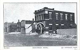
The Qu'Appelle Royal Bank of Canada branch, built in 1906 by the Northern Bank and taken over by the Royal Bank of Canada in 1925, is located on the east side of Main Street. The branch continued to operate until the 1960s when reduced commercial activity in Qu'Appelle and declining population in the hinterland made it no longer viable. The building is now in use as a commercial laboratory.
By the 1960s there still remained a small business core, gas station, grocery store, butcher shop, insurance agency, post office, two restaurants, bar, greenhouses, transport grain storage, hair dresser, a print shop, tattoo parlour and analytical laboratory.[7] The Odd Fellows, a local service club, is long dissolved. There still remains a Masons lodge, a Lions Club, the Community Players and a Historical Society.[40] Skating rink, baseball diamonds, with a nearby indoor horseback riding arenas, elementary school and RM office.
The "Opera House" — the auditorium in the Town Hall — is long closed and remains unused, having failed to conform to contemporary safety regulations.[41] The disused former Red & White grocery store on main street, one of the few buildings still standing, is now converted to use as a community hall in default of the Town Hall auditorium's continuing utility.
By the 1960s many farmers were working in winter in "town" — not Qu'Appelle, whose commercial vitality had by now entirely lapsed, but certainly Fort Qu'Appelle and indeed Regina — and winter social activities in the former rural communities had entirely lapsed. Farming had become a part-time summer job for farmers, who previously would have regarded farming as their principal occupation and wintertime jobs as a distraction.
The availability of unlimited water on farmsteads became an issue when the Government of Saskatchewan at length permitted the subdivision of farmsteads: when this became viable, numerous luxurious farmsteads became attractive venues for townspeople to set up summer homes on former Qu'Appelle district farmsteads with the former farms consolidated as large-scale commercial operations having no relationship whatever with their former farmsteads.
However, the rural population which Qu'Appelle had served steadily declined as family farms were consolidated: The Dominion Lands Act, 1872 had provided for farms of 160 acres (65 ha) or ¼ section,[42] a section being one square mile (2.5 km2). The Depression of the 1930s made it clear that while this might have been enough land for a family farm in eastern Canada, it was not nearly enough in the dryland farming conditions of the prairies, and farmers steadily sold up or bought up, farm sizes increased and the hinterland population waned.
Rural churches, largely Presbyterian and then as of 1925 United Church, served by ministers based in Qu'Appelle, Indian Head and Fort Qu'Appelle, and rural one-room schools closed by the late 1950s and early 1960s respectively: all rural churches were gone by 1960 and the remaining rural schools were closed in June 1963; farm children were thereafter bused to town school. Little trace of either now remains as rural schools' and churches' property was resumed by local farmers.
Geography

Qu'Appelle is located in the Indian Head Plain of the Aspen Parkland ecoregion[43] on the parkland of the Qu'Appelle flood plain.[43] Qu'Appelle's elevation is 662.90 m (2,174.9 ft) above sea level. The area is characterised by lush rolling grasslands, interspersed with poplar bluffs (in prairie Canadian terminology poplar groves surrounding sloughs) and open sloughs. Qu'Appelle is located in the transition zone between the Qu'Appelle River and the corresponding Qu'Appelle Valley and the Canadian Prairies.
To the visitor, southern Saskatchewan Qu'Appelle Valley might, at first glance, appear to be a mirage. Bordered by seemingly-endless farmland flatness, the dramatic physical features of the valley appear somewhat out of place.[44]
Echo Creek (occasionally known as Springbrook Creek) rises immediately to the north of Qu'Appelle and opens out into a broad coulee immediately to the south of the Qu'Appelle Valley. In the past it ran dry by late summer; global warming or other factors have caused it to run freely throughout the summer and to have fish swimming freely in it till the fall freeze-up. Beavers occasionally dam the creek in the spring using the poplars that line its coulee; at various points it opens up into ponds where in the past when the Qu'Appelle region was amply populated farm children swam.
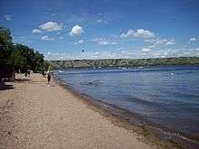
Natural features of Egg Lake (20.6 km (13 mi)); Echo Creek (14.8 km (9 mi)); the Fishing Lakes (25.1 km (16 mi)) and Strawberry Lakes (27.7 km (17 mi)) are near Qu'Appelle.[45] The Fishing Lakes—Katepwa, Mission, Echo and Pasqua Lakes—immediately to the north of the Qu'Appelle in the Qu'Appelle Valley, are all fed by the Qu'Appelle River.[46]
"[I]in the years prior to World War I ...he recreational potential of the district began to be exploited and numerous cottages began to appear on the area lakes."[47] The lakes afford swimming, boating and other water related activities in summer and cross-country skiing, snowmobiling and ice fishing in winter.[48] There is also Echo Valley Provincial Park located between Echo Lake and Pasqua Lake. The park provides an RV park, camping, swimming, boating and fishing.[49]
The Indian Head Bird Sanctuary, maintained by the Canada Agriculture Experimental Farm Tree Nursery is located 14 km (9 mi) east of Qu'Appelle. The sanctuary is a mixed-grass prairie eco-region and wetlands created by the damming of the Indian Head Creek.[50][51]
Climate

Qu'Appelle has a humid continental climate with frigid, dry winters and warm summers. Qu'Appelle's winters can be uncomfortably cold; but warm, dry Chinook winds routinely blow into the area from the Pacific Ocean during the winter months, providing the occasional break from the cold especially during the times of El Niño-Southern Oscillation. These winds have been known to raise the winter temperature by up to 15 °C (27 °F) in just a few hours.
Qu'Appelle is a town of extremes, and temperatures have ranged anywhere from a record low of −48.3 °C (−55 °F) on 1 February 1893[52] to a record high of 41.7 °C (107 °F) on 5 July 1937.[53] According to Environment Canada, the average temperature in Qu'Appelle ranges from a January daily average of −14.2 °C (6.4 °F) to a July daily average of 18.5 °C (65.3 °F).[54] As a consequence of Qu'Appelle's relative dryness, summer evenings can be very cool, the average summer minimum temperature drops to 10.6 °C (51.1 °F).
Qu'Appelle receives an average of 455.4 mm (17.93 in) of precipitation annually, with 342.5 mm (13.48 in) of that occurring in the form of rain, and 113.0 cm (44.5 in) falling as snow.[54] Most of the precipitation occurs from May to August, with June and July averaging the most monthly rainfall. On 13 July 1981, Qu'Appelle received 113.1 mm (4.45 in) of precipitation, making it the wettest day in the town's recorded history.[54] On 12 May 1983, Qu'Appelle received 45 cm (18 in) of snowfall, providing the snowiest day in the town's recorded history.[54] Droughts are not uncommon and may occur at any time of the year, lasting sometimes for months or even several years.
| Climate data for Qu'Appelle, 1981–2010 normals, extremes 1877–present | |||||||||||||
|---|---|---|---|---|---|---|---|---|---|---|---|---|---|
| Month | Jan | Feb | Mar | Apr | May | Jun | Jul | Aug | Sep | Oct | Nov | Dec | Year |
| Record high °C (°F) | 12.8 (55) |
13.9 (57) |
24.4 (75.9) |
31.5 (88.7) |
37.0 (98.6) |
38.5 (101.3) |
41.7 (107.1) |
38.3 (100.9) |
35.0 (95) |
31.5 (88.7) |
22.8 (73) |
17.8 (64) |
41.7 (107.1) |
| Average high °C (°F) | −9.4 (15.1) |
−6.7 (19.9) |
-0.0 (32) |
11.0 (51.8) |
17.7 (63.9) |
21.7 (71.1) |
25.0 (77) |
24.5 (76.1) |
18.2 (64.8) |
10.1 (50.2) |
−0.8 (30.6) |
−7.5 (18.5) |
8.7 (47.7) |
| Daily mean °C (°F) | −14.2 (6.4) |
−11.4 (11.5) |
−4.9 (23.2) |
4.6 (40.3) |
11.0 (51.8) |
15.6 (60.1) |
18.5 (65.3) |
17.7 (63.9) |
11.8 (53.2) |
4.5 (40.1) |
−5.1 (22.8) |
−12.0 (10.4) |
3.0 (37.4) |
| Average low °C (°F) | −18.9 (−2) |
−16.1 (3) |
−9.8 (14.4) |
−1.9 (28.6) |
4.3 (39.7) |
9.5 (49.1) |
12.0 (53.6) |
10.9 (51.6) |
5.3 (41.5) |
−1.2 (29.8) |
−9.4 (15.1) |
−16.4 (2.5) |
−2.7 (27.1) |
| Record low °C (°F) | −45.6 (−50.1) |
−48.3 (−54.9) |
−42.8 (−45) |
−31.1 (−24) |
−13.3 (8.1) |
−3.9 (25) |
−1.1 (30) |
−3.9 (25) |
−12.2 (10) |
−25.6 (−14.1) |
−34.4 (−29.9) |
−42.0 (−43.6) |
−48.3 (−54.9) |
| Average precipitation mm (inches) | 15.6 (0.614) |
11.5 (0.453) |
23.1 (0.909) |
26.9 (1.059) |
60.6 (2.386) |
83.2 (3.276) |
74.7 (2.941) |
57.8 (2.276) |
38.2 (1.504) |
26.4 (1.039) |
18.0 (0.709) |
19.5 (0.768) |
455.4 (17.929) |
| Average rainfall mm (inches) | 0.5 (0.02) |
0.5 (0.02) |
3.8 (0.15) |
14.8 (0.583) |
52.0 (2.047) |
82.9 (3.264) |
74.7 (2.941) |
57.8 (2.276) |
35.5 (1.398) |
17.5 (0.689) |
1.8 (0.071) |
0.6 (0.024) |
342.5 (13.484) |
| Average snowfall cm (inches) | 15.1 (5.94) |
11.0 (4.33) |
19.4 (7.64) |
12.1 (4.76) |
8.6 (3.39) |
0.2 (0.08) |
0.0 (0) |
0.0 (0) |
2.7 (1.06) |
8.9 (3.5) |
16.2 (6.38) |
18.9 (7.44) |
113.0 (44.49) |
| Source: Environment Canada[54][55] | |||||||||||||
Demographics
| Historical Population | ||
|---|---|---|
| Year | Pop. | ±% |
| 1901 | 434 | — |
| 1906 | 778 | +79.3% |
| 1910 | 851 | +9.4% |
| 1916 | 722 | −15.2% |
| 1996 | 632 | −12.5% |
| 2001 | 648 | +2.5% |
| 2006 | 624 | −3.7% |
| [56][57][58] | ||
The town's population increased 7.1% to 668 persons in the 2011 census.[59] The population density rose to 158.1 inhabitants per square kilometre (409/sq mi), over 81% of the population are adults, with the median age of the town's population being about 39.2 years of age.

The 2006 Statistics Canada data estimates the town's population at 624[56] residents, continuing a trend of population decline in the town since the 2001 Census. Of this population, 48.8 per cent were male and 51.2 per cent were female. Children under five accounted for approximately 4.8 per cent of the resident population of Qu'Appelle.[56]
Between 2001 and 2006, Qu'Appelle's population decreased by 3.7 percent: not a vast loss in number of town-residents even since the town's prime, it being reduction in nearby farm population, grain elevators and highway transport that have caused it to lose or have much reduced its once substantial commercial, education, religious and entertainment activity. During the same time period, the population of Saskatchewan decreased by 1.1 percent, while that of Canada grew by 5.4 percent. The population density of Qu'Appelle averaged 147.7 inhabitants per square kilometre (383/sq mi), compared with an average of 1.6 per square kilometre (4.1/sq mi) for the province.[56] According to data from 2001 (although with so small a population percentages are not especially informative) more than 36.9% of the town's residents identify themselves as Roman Catholic; 38.46% of residents are Protestant, 2.3% are undifferentiated Christian, 5.38% are Buddhist, and 16.9% of residents do not practise a religion.[57]
Qu'Appelle is a part of Census Division No. 6. Qu'Appelle and area do not belong to a Saskatchewan Regional Economic Development Authority, REDA.[60]
According to the Canada 2001 Census the community profile was as follows:
- Population in 1996 — 632
| Canada census – Qu'Appelle, Saskatchewan community profile | |||
|---|---|---|---|
| 2011 | 2006 | 2001 | |
| Population: | 668 (+7.1% from 2006) | 624 (-3.7% from 2001) | 648 (+2.5% from 1996) |
| Land area: | 4.22 km2 (1.63 sq mi) | 4.22 km2 (1.63 sq mi) | 4.22 km2 (1.63 sq mi) |
| Population density: | 158.1/km2 (409/sq mi) | 147.7/km2 (383/sq mi) | 153.4/km2 (397/sq mi) |
| Median age: | 39.2 (M: 38.2, F: 40.4) | N/A (M: N/A, F: N/A) | |
| Total private dwellings: | 286 | 288 | 290 |
| Median household income: | $N/A | $N/A | |
| References: 2011[61] 2006[62] 2001[63] | |||
- N/A = Data Not Available
Media

The Qu'Appelle Progress, the town newspaper, began production at the very outset of Qu'Appelle's establishment and maintained publication till the mid-1960s. It originally provided substantive news as to national and international events when access to wider news organs was not locally available.
Latterly it devolved to a local community paper, largely subsisting on reports from farm wives as to the waning hinterland rural communities. Community reporters phoned in accounts of events in such now historic rural communities as Inglewood, Strathcarroll and Springbrook.
Rural community life increasingly lapsed through the 1960s and reports from farm wives to the Qu'Appelle Progress of community events became redundant as such rural communities waned, lost cohesion (country United Churches closing in the 1950s; country schools the end of June 1963) and ultimately vanished.
By that time such rural communities had passed into their brief, three-generation history, Heber Ellis, the editor and publisher of The Progress had reached the end of his life and The Progress died soon after him.
Nowadays the Qu'Appelle Spirit Monthly newsletter provides local reporting from volunteers.[64]
Governance
The town of Qu'Appelle was incorporated February 20, 1903[13] when, ironically, its halcyon days when anticipation that it would be of significant importance ecclesiastically and possibly in government and commerce were already long behind it.
Municipal affairs are handled by the town mayor and council.[65] The rural municipality of South Qu'appelle No. 157 office is located in Qu'Appelle and provides municipal rural affairs to the small localities of Avonhurst, Edgeley, Grassmere, Green Haven, Qu'Appelle Airport and St. Josephs Colony.[66] South Qu'Appelle RM in 1885 was a large area comprising more than 18 townships with an area of 592 square miles (1,530 km2). Due its size, the council divided into 27 road districts and appointed road overseers to maintain construction and maintenance of early roads.[13]:[87]
Qu'Appelle is in the federal electoral district of Regina—Qu'Appelle (formerly Qu'Appelle).[67]
Provincially, the area is within the constituency of Indian Head-Milestone.[68]
Education

Bishop Adelbert Anson, the first Bishop of Qu'Appelle (1884–1892), established the St John's College Farm, a boys' school, agricultural and theological college shortly after his arrival in the diocese in 1884. When it became clear that funding from eastern Canada, the heartland of Canadian Anglicanism, would not be forthcoming,[69] English funding for the Anglican mission on the Canadian prairies soon dried up and St. John's College dissolved shortly after Bishop Anson's departure in 1893.[13]
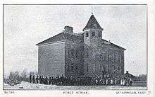
December 5, 1884 saw the creation of the first two school districts in the North-West Territories; Moose Jaw School District #1 and Qu'Appelle School District #2. The wood frame two- or three-classroom school house gave way to a 2½- storey brick school with full basement in 1906.
Despite the town's decline, Qu'Appelle School had a new, though temporary, lease on life in 1963 when the new consolidated school unit came in, rural schools closed and farm children began to be driven to school in Qu'Appelle daily.
However, education planners did not anticipate how quickly both the town's own and its far region's population and its town-commercial outlets would continue to decline. The farm seeking and supplying area surrounding town would continue to be steadily evacuated of people as the 1950s through 1970s drew on: Qu'Áppelle School, long together with the town hall a centre of community activity, was closed in 1973 and demolished in 1975.

November 27, 1964 saw the opening of the nine-classroom brick James Hamblin School.[13] Elementary school education from kindergarten to grade 9 is provided there; it is administered by the Qu'Appelle Valley School Division No. 139.[70]
The primary school of 1964 was under the longstanding 1906 high school in academic progress for less than a decade. Secondary school has not been available in Qu'Appelle since 1973 when Qu'Appelle High School closed and high school students from Qu'Appelle must travel to Bert Fox Community High School in Fort Qu'Appelle, part of the Prairie Valley School Division No 208.[71] or to Indian Head High School.
Churches
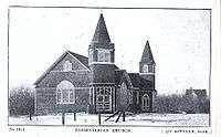
St. Peter's Church of England Pro-Cathedral
 St. Peter's Pro-Cathedral first decade of the 20th century
 St Peter's Pro-Cathedral, Qu'Appelle with the Terrace, circa 1920s
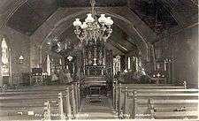 St. Peter's Pro-Cathedral, Qu'Appelle, interior, circa 1900
 St. Peter's, Qu'Appelle, interior, 2008
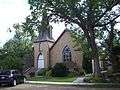 St Peter's (former) Pro-Cathedral, Qu'Appelle, 2008
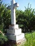 Grave of Bishop John Burn, who died in 1896
In anticipation of its presumed eventual urban importance the Anglican ecclesiastical province of Ruperts Land designated the village of Qu'Appelle as the cathedral city of the new diocese of Qu'Appelle of the Church of England (since 1955 the Anglican Church of Canada).[23] The diocese of Qu'Appelle still retains that name, though the historic association with the town of Qu'Appelle other than as a subsidiary congregation of the parish of Indian Head is long past. St Peter's, the pro-cathedral, was built in 1885. Its stone rectory next door, built in 1894, is now in private hands,[18] the church (as with the other three denominations) having long since withdrawn any full-time residential clergy from the town.
Bishop Adelbert Anson, the first Bishop of Qu'Appelle (1884), cultivated a relationship between Qu'Appelle and his home Diocese of Lichfield in England and with wealthy friends there. They briefly took on both Diocese of Qu'Appelle as a mission field and the parish of St Peter's Pro-Cathedral as a particular focus of interest. Much of the early development of the St John's College Farm and the furnishing of St Peter's Pro-Cathedral are attributable to that early connection.[13] The diocese briefly operated a training facility for Anglican clergy in the town and the St John's College Farm, a model farm immediately to the west of town.[72] Bishop Burn, who lacked Bishop Anson's connections with patrons in the Diocese of Lichfield, closed both of these facilities in 1895. The parish church of St Peter's, however, continued as the pro-cathedral for southern Saskatchewan until 1944.[7] The original Bishop's Court, the official residence of the diocesan bishop, was also in Qu'Appelle. It was moved by John Burn, the second bishop of Qu'Appelle, to Indian Head, some 8 miles (13 km) to the east of Qu'Appelle, in 1896 when he closed the college. It had become apparent that
- (a) diocesan debt was becoming disproportionate to anticipated resources in the largely non-Anglican District of Assiniboia and
- (b) the sponsoring Diocese of Lichfield in England was unwilling to underwrite the expenses of such programs indefinitely.[73]
Early on, the bishop's residence was further relocated from Indian Head to the new diocesan property in Regina. Still, when Bishop Burn died he was buried in Qu'Appelle Cemetery, where his grave monument remains the largest. Ultimately, with the ecclesiastical hierarchy and the provincial metropolis long since having been removed to Regina, pro-cathedral status was removed from St Peter's, Qu'Appelle and conferred on St Paul's, Regina in 1944. (However, even Regina's continuing status as an episcopal see city and that of St Paul's, Regina as a cathedral may now be in doubt as the further declining Anglican Church rationalises its increasingly top-heavy episcopal structure.[74])
Qu'Appelle Methodist, Knox Presbyterian and from 1925 United; St Andrew's Presbyterian
The Church of England parish of St. Peter's having been substantially constituted by English immigrants, the native Canadian Protestant arrivals at Qu'Appelle established two churches:
(1) the Qu'Appelle Methodist Church, which opened in 1883 as part of a circuit that included Edgeley, Saskatchewan Methodist Church.[23][75] and
(2) Knox Presbyterian Church, built in 1884.[7]

The Presbyterian and Methodist congregations merged in 1925 to become a congregation of the United Church of Canada. They maintained the Presbyterian church building as its facility and with the minister of Qu'Appelle Methodist Church continuing at the present day Knox United.[76]
The Presbyterians of Qu'Appelle were so substantial a body that when a non-concurring minority of their congregation seceded and re-constituted themselves a separate continuing Presbyterian congregation, building a new meeting house on Main Street for their St Andrew's Presbyterian Church, both congregations remained viable:[77]
Those who went into the union still constituted a majority of the United Church congregation and both were able to maintain a vital presence in the town for many years, with St. Andrew's continuing Presbyterian congregation sharing a minister with Indian Head. From the beginning of the church union in 1925 it was clear that the continuing Presbyterians could no longer support their own local clergyman and Indian Head supplied the Qu'Appelle Presbyterians with a commuting minister who travelled to Qu'Appelle each Sunday.
For a generation the church union issue raised hackles in Qu'Appelle among uniting and non-concurring Presbyterians and many firm friendships were sundered. Nowadays as elsewhere in Canada, as the matter has passed into history and matters of denominational affiliation have largely become moot in Canada's increasingly secular society, the issue is largely forgotten. In 2013 "[congregation] of Qu'Appelle ...[moved towards] congregational closure and sale of the church [building]."[78]

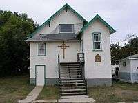
Roman Catholic Church of the Immaculate Conception
The Roman Catholics built the fine Immaculate Conception Church on Main Street in 1906 (consecrated in 1907). The building is in the same yellow brick as the town hall and former school, the pro-cathedral and numerous houses and Main Street businesses, which once characterised the town's not-unimpressive yellow brick style.
Immaculate Conception parish began in 1886. Its original church building survives as a private residential dwelling. Whereas Presbyterian and Methodist, and later United, churches maintained rural congregations in which farm families locally worshipped and conducted community events, Roman Catholics as with Anglicans came to town for Sunday services and liturgical festivals and from the outset the Catholic Church in Qu'Appelle had a substantial urban presence.
The Roman Catholic constituency in Qu'Appelle was originally French, German and Métis. As Canadian denominational affiliation has become increasingly amorphous, the Church of the Immaculate Conception's Catholicism has largely ceased to have ethnic significance.
The Parish of the Immaculate Conception has the largest church building in the town, seating up to 225. It has the most vital single surviving congregation in the town, albeit as with the Anglican, United Church and continuing Presbyterian congregations, long since without a resident clergyman.[79]
The Qu’Appelle Deanery is one of 9 deaneries within the Archdiocese of Regina. [The]...deanery is comprised of 19 rural parishes" including "Indian Head - St. Joseph[,] Wolseley - Ste. Anne[,] Grenfell - St. Columbkille[,] Qu'Appelle - Immaculate Conception[.][80]
Cultural events and entertainment
In Qu'Appelle's early days, churches as well as the school constituted a major focus of community social as well as religious life through the year. Social events involving the whole community occurred when the town organised

- St George's Day celebrations on April 23,
- May Day celebrations on May 1,
- Victoria Day fireworks on May 24,
- a parade for Dominion Day on July 1,
- a summer agricultural fair in July, [81]
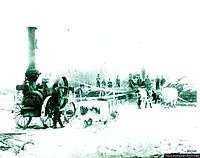
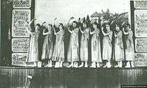
 Cattle display at Qu'Appelle Summer Fair, 1898
 - school plays and concerts at Christmas and in the spring,[82]
- amateur community concerts and theatricals in the "opera house" in the Town Hall;
- cricket matches and later, as the English constituency waned,
- community baseball games
- hockey games in the indoor community rink.
The town's churches mounted parish, congregational, Sunday School and other events through the year which were a focus of social activity for members of the four religious denominations of the town: the Church of England, Roman Catholics, Presbyterians, Methodists (later United Church, containing all the Methodists and the majority of the Presbyterians) and, after the 1925 church union, the continuing Presbyterian congregation.
There was also the previously mentioned cinema on Main Street; during the early years of the building's existence a horseshoe pitch was set up and used alongside.[13]:[741] A curling club and curling rink were established in the late 1880s.[13]
Sports and other secular recreation

Dealing again with Qu'Appelle's lively historical past, horse racing and harness racing were the earliest recreational activities in the area, with several avid horsemen competing in annual events.[23] Cricket matches and hockey games were early community activities; lantern slides and movie shows were enjoyed in the late 19th century and onward when church halls and, later, when in the 1900s through the 1950s the town cinema on Main Street provided movies.[13]:[601]
Moving to today's diminished liveliness within the town, the Recreation and Culture Committee oversees the activities at the skating rink, Centennial and Capital Day Parks, Community Hall, tennis court and library.[83] The Mclean Recreation Site 17 km (11 mi) west of Qu'Appelle has a picnic area.[84][85]
In the Qu'Appelle Valley are B-Say-Tah Point on Echo Lake, Valley Centre Recreation Site (29 km or 18 mi) also on Echo Lake, Sandy Beach and Katepwa Point Provincial Park 27.2 kilometres (16.9 mi) on Katepwa Lake, Lebret Recreation Site 29 kilometres (18 mi) on Mission Lake and Echo Valley Provincial Park 30 kilometres (19 mi) on Pasqua Lake.
Katepwa Point Provincial Park at the eastern end of Katepwa Lake, the eastern-most of the four Fishing Lakes in the Qu'Appelle Valley, features a picnic area, beach, nine-hole golf course, miniature golf course, fishing, boating and campground.[86] This popular beach is located on Katepwa Road.[46] Mission Ridge on Mission Lake is a winter ski resort.
Infrastructure
Transport
When the rail arrived in 1882, the Troy (Qu'Appelle)-Prince Albert trail served freight and stagecoach transport to the north-west and onwards to Edmonton.[87] The CPR formerly provided passenger service east and west from Qu'Appelle and generally throughout the province.

Early bishops of the Church of England Diocese of Qu'Appelle were able to travel by train from their original see "city" of Qu'Appelle to parishes throughout what was then the District of Assiniboia in the North-West (sic) Territories, in 1905 becoming southern Saskatchewan. CPR passenger services were heavily used before the arrival of widespread private motor vehicle ownership and again during the Depression from 1929 through World War II; the CPR continues to run past Qu'Appelle but no longer maintains a station or indeed routine passenger facilities; nor are there any longer grain elevators.
The Trans-Canada Highway was built some one kilometre to the south of both the CPR tracks and the old east-west highway, bypassing Qu'Appelle and significantly reducing traffic through the town. Highway 35 runs south to Weyburn unpaved and north to Fort Qu'Appelle; while no longer heavily trafficked since the opening of Highway 10 from Balgonie to the Valley, it is still paved on the northward sector, although with the drastically depleted traffic demand with reduced population both in town and on farms, largely eliminated Regina-to-Qu'Appelle Valley traffic and loss of grain elevators, gasoline and vehicle repair stations (into the 1960s there was still one gasoline station in town and one on each side of number 1 highway), retail stores, post office, bank, hospital, high school and movie theatre it is inevitably falling into reduced maintenance of pavement.
Utilities
Qu'Appelle was home to a North-West Mounted Police barracks established by Major Walsh in 1882[13]:[196] and until the 1950s there was a resident RCMP town constable. Early water was supplied by digging wells 10 to 20 feet (3.0–6.1 m) deep, until the 1930s when a 300-foot (91 m) well was dug.[13]:[29] 1962 saw the construction of a 500-gallon (2250 l) water tower as well as the first town fire hydrant.[13]:[31] The town foreman co-ordinates and manages the Public Works & Utilities Department. Qu'Appelle and the surrounding rural municipality of South Qu'Appelle No. 157 are served by the Qu'Appelle Volunteer Fire Department, who are trained in health care and fire rescue practices.[88] Today the Indian Head RCMP detachment provides police protection for the community.[89]
Healthcare
Nowadays of course the population is far too thin to demand the medical services that were readily provided in past years. The town had a medical doctor living in the town from the early 1880s until the mid-1960s and for many years virtually all town and hinterland births occurred in Qu'Appelle Memorial Hospital, which opened on March 3, 1946 and closed March 1, 1969.[13]:[127] Diphtheria, smallpox, measles, scarlet fever and typhoid fever were early epidemics to hit the town.[13]:[123] Midwives were employed in childbirth deliveries.
The Regina Qu'Appelle Regional Health Authority assesses and provides health care within the Regina-Qu'Appelle region.[90] Regina[91] and Indian Head both have hospitals and special care homes in the Regina Qu'Appelle Regional Health Authority region which are near to Qu'Appelle.[92] Fort Qu'Appelle is home to the Fort Qu'Appelle Community Health Services Centre, All Nations' Healing Hospital and the Echo Lodge Special Care Home.[91]
Notable people in or from Qu'Appelle
 Vernon Barford
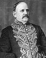 George Hedley Vicars Bulyea
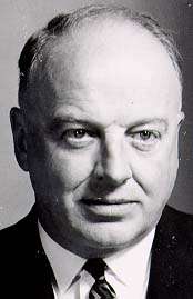 Edward A. Rawlinson
 Michael Greyeyes
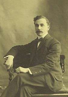
- Vernon Barford, (10 September 1876 - 22 April 1963) organist, choirmaster, teacher, homesteader in the Qu'Appelle district between 1895 and 1900.[93]
- George H. V. Bulyea, Canadian politician moved to Qu'Appelle, District of Assiniboia, North-West Territories in 1893. He taught at Qu'Appelle High School. In 1905, he was appointed the first Lieutenant Governor of Alberta.
- Percival Gordon, a judge of the Saskatchewan Court of Appeal, born and educated as to primary and high school in Qu'Appelle.
- Group Captain Claude Hilton Keith (1891–1966), born in Qu'Appelle, was an early pioneer of air gunnery who played a central role in the preparation of the Royal Air Force for World War Two. His career ended prematurely after championing the rights of R.A.F personnel posted in Canada.
- Doug Killoh, played with the Saskatchewan Roughriders
- Edward Rawlinson, (June 2, 1912 – 1992), born in Qu'Appelle showed leadership in broadcasting across several radio stations to Saskatchewan and was the youngest chartered accountant in Canada.[94]
- Neil Schell, actor was born 24 April 1957, in Qu'Appelle. He has starred in a variety of television series and movies such as most recently A Little Thing Called Murder (2006) and Cabin Pressure / Hijack'd (2006).[95]
- Michael Greyeyes, an actor, dancer, choreographer, director, and educator.
See also
- List of communities in Saskatchewan
- List of towns in Saskatchewan
- Anglican Diocese of Qu'Appelle
- Anglican Church of Canada
Notes
- ↑ The Diocese of Qu'Appelle geographically remains largely coterminus with the old District of Assiniboia in the North-West Territories, though a strip of the diocese which fell over the 1905 boundary between the new provinces of Saskatchewan and Alberta was ceded to the Diocese of Calgary in the 1970s.
- ↑ David McLennon, "Qu'Appelle," Encyclopedia of Saskatchewan Retrieved 29 November 2008.
- 1 2 "Item Display - Post Offices and Postmasters - Library and Archives Canada". Collections Canada. Government of Canada. Retrieved 2008-09-17.
- ↑ Sumner, Len W (1980). Raw prairie to grain elevators : the chronicles of a pioneer community, Duff, Saskatchewan. Toronto: Dundern Press. ISBN 0-9690357-0-5.
- ↑ David McLennon, "Qu'Appelle," Encyclopedia of Saskatchewan, retrieved 30 September 2008.
- ↑ "Emily Pauline Johnson (10 March 1861 – 7 March 1913 / Chiefswood, Ontario)." Retrieved July 1, 2013.
- 1 2 3 4 5 6 7 8 9 10 McLennan, David. "Qu'Appelle". The Encyclopedia of Saskatchewan. CANADIAN PLAINS RESEARCH CENTER, UNIVERSITY OF REGINA. Retrieved 2007-07-13.
- ↑ "Valley of Qu'Appelle is Full of Historic Interest". The Leader-Post, Regina. Google News Archive Search. June 23, 1959. Retrieved 2013-02-10.
There is now no sign of the first Hudson's Bay Company Trading Post at Qu'Appelle, 20 miles south of the lakes.
- ↑ David McLennon, "Qu'Appele," Encyclopedia of Saskatchewan, retrieved 7 February 2009.
- ↑ Barry, Bill (2005). Geographic Names of Saskatchewan. First printing. Regina, SK: People Places Publishing Ltd. ISBN 978-1897010198.
- ↑ "Other Centers Fought for Capital Site" (Digitised online). The Leder Post. Google News Archive Search. June 18, 1963. Retrieved 2013-02-10.
When the southern route [of the C.P.R. trans-continental railway] finally was chosen there were five strong bids for the site of the capital, but Lt.-Gov. Dewdney rejected those from Indian Head, Qu'Appelle, Fort Qu'Appelle, and Moose Jaw.
- ↑ Pierre Berton, The Last Spike: The Great Railway 1881-1885 (Toronto: McLelland and Stewart, 1973), 120.
- 1 2 3 4 5 6 7 8 9 10 11 12 13 14 15 16 17 18 19 20 21 Qu'Appelle Historical Society (1980). "Qu'Appelle : footprints to progress: a history of Qu'Appelle and district". republished online University of Calgary, Université Laval: Our Roots Nos Racines: 27.
- ↑ David J. Hall, "North-West Territories," The Canadian Encyclopedia. Retrieved 19 November 2007.
- ↑ David MacLennon, Qu'Appelle, Encyclopedia of Saskatchewan, retrieved 20 April 2009.
- ↑ Bob Beal and Rod MacLeod, "North-West Rebellion." The Canadian Encyclopedia. http://www.thecanadianencyclopedia.com/articles/northwest-rebellion Retrieved July 16, 2013.
- ↑ Cf references, passim, in Laura Ingalls Wilder's "Little House" books: contemporary attitudes of South Dakota from 1880, when settlement opened there, are obviously precisely coterminous with such attitudes in the District of Assiniboia some 2-3 years later, notwithstanding the wide divergence between immediately adjacent Canadian provinces and American states as to issues such as gun control and abortion.
- 1 2 David McLennan, "Qu'Appelle," The Encyclopedia of Saskatchewan. http://esask.uregina.ca/entry/quappelle.html Retrieved January 30, 2013.
- ↑ Campbell, Maria (January 1, 1983). Half-Breed. Goodread Biography. ISBN 0-88780-116-1.
- ↑ Starr, D. Henry; Marijan Salopek (17 July 1894). "Reaction to German Immigration" (Letters republished online). Letter from D. Henry Starr, (Starr's Point, Qu'Appelle Station, Assiniboia, N.W.T.) to T. M. Daly, Minister of Interior, 17 July 1894. Public Archives of Canada, RCMP Records, Section A-1, vol 97, 71 no. 587. Retrieved 2008-09-19. horizontal tab character in
|publisher=at position 67 (help) - ↑ Qu'Appelle: footprints to progress: a history of Qu'Appelle and district Retrieved 15 March 2009.
- ↑ Edifice & Us - 'The Qu'Appelle Opera House' Episode Info - MSN TV
- 1 2 3 4 5 Hawkes, John (2005). "SASKATCHEWAN AND ITS PEOPLE". Saskatchewan Gen Web Project. Adamson, Julia. Retrieved 2008-09-19.
- ↑ observatory
- ↑ Qu'Appelle Historical Society, Qu'Appelle: Footprints to Progress (Qu'Appelle, 1980), 22.
- ↑ David McLennan, "Qu'Appelle," The Encyclopedia of Saskatchewan http://esask.uregina.ca/entry/quappelle.html. Retrieved January 30, 2013.
- ↑ Elizabeth Mooney, "Prohibition and Temperance," Encyclopedia of Saskatchewan, retrieved 7 February 2009.
- ↑ "Life on the Prairies - Hockey Saskatchewan Settlement Experience". Saskatchewan Archives Board. OH! Media. 2005. Retrieved 2008-09-19. Note this photo of covered rink and equipment
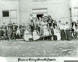
- ↑ "This group of people gathered for a picnic at St. John's College Farm in Qu'Appelle. Saskatchewan Settlement Experience". Saskatchewan Archives Board. OH! Media. 2005. Retrieved 2007-06-13. Picnic photo
- ↑ "Photograph of Qu'Appelle Fair, 1898.. Saskatchewan Settlement Experience". Saskatchewan Archives Board. OH! Media. 2005. Retrieved 2007-12-04. Photograph of summer fair.
- ↑ Until the building of Highway 10, vastly reducing the use of Highway 35 between Qu'Appelle and Fort Qu'Appelle, access by farm families to Qu'Appelle was much more convenient than to the Fort.
- 1 2 Federal Reserve Bank of Minneapolis Community Development Project. "Consumer Price Index (estimate) 1800–". Federal Reserve Bank of Minneapolis. Retrieved October 21, 2016.
- 1 2 "A History of the Canadian Dollar". Le Site De Justiceplus - The Justiceplus Site. Archived from the original on December 21, 2008. Retrieved 2008-12-28. Rationale to use US currency conversion template. $10 Canadian was equivalent to US$10 gold eagle 1851-1867. 1879-1914 the US and Canadian dollar traded again at par.
- 1 2 "The Canadian Dollar under the Gold Standard (1854-1914)" (PDF). Bank of Canada. Archived from the original (pdf) on February 24, 2009. Retrieved 2008-12-28. Rationale to use US currency conversion template. Bank of Canada notes that from 1854-1914 the US and Canadian dollar traded at par)
- ↑ "EVOLUTION OF TOWNS AND VILLAGES. MEMORIES OF QU'APPELLE. 1883.". Saskatchewan and Its People. Saskatchewan Gen Web. 2 September 2002. Retrieved 2014-03-21.
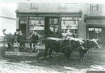
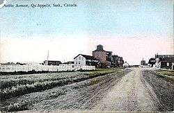
- ↑ Note: (a) the extraordinarily wide main street, in contemplation of the town's anticipated metropolitan importance; (b) the grain elevator (one of several) adjacent to the CPR tracks at the south end of Main Street; (c) the substantially brick rather than timber buildings, anticipating permanent importance for the town; (d) the signs and canvass awnings of the commercial establishments, indicating the considerable vitality of trade and commerce in turn of the 20th-century Qu'Appelle; (e) the fully occupied commercial lots along the street, since the 1950s incrementally vacated; (f) the horse-drawn vehicles drawn up along the street at the time of an obviously early-morning photo-shoot.
- ↑ Maclennon.
- ↑ Royalite Oil Company Ltd. was acquired by British American Oil in 1964; both the Royalite and BA names were retired in 1969 when their operations were combined under the name Gulf Oil Canada Ltd. See "Royalite Oil Company Ltd.," Alberta Online Encyclopedia. Retrieved 1 March 2009.
- ↑ Qu'Appelle Valley School District website. Retrieved 4 December 2007.
- ↑ Town of Qu'Appelle website. Retrieved 4 December 2007.
- ↑ "The Qu'Appelle Opera House." Retrieved 8 October 2008.
- ↑ Elizabeth Mooney, "Dominion Lands Act / Homestead Act," Encyclopedia of Saskatchewan, Retrieved 18 September 2008
- 1 2 Fung, Ka-iu; Barry, Bill (1999). Atlas of Saskatchewan (Celebrating the Millennium ed.). Saskatoon: University of Saskatchewan. ISBN 0-88880-387-7.
- ↑ Peterson, Bill (June 12, 1978). "Qu'Appelle Covered in Book". The Phoenix. Google News Archive Search. Retrieved 2013-02-10.
- ↑ "Qu'Appelle, Saskatchewan, Canada". This is the world as we know it. Government of Canada. 2008-09-18. Retrieved 2008-09-17.
- 1 2 Yanko, Dave (1997–2007). "Virtual Saskatchewan - Qu'Appelle Valley". Tourism Saskatchewan. Government of Canada. Retrieved 2008-09-17.
- ↑ David McLennan, "Fort Qu'Appelle." The Encyclopedia of Saskatchewan. http://esask.uregina.ca/entry/fort_quappelle.html August 20, 2012.
- ↑ "Qu'Appelle valley is big attraction for visitors". The Leader-Post. Google News Archive Search. June 23, 1959. Retrieved 2013-02-10.
- ↑ Clancy, Michael T.; Anna Clancy; University of Regina. Canadian Plains Research Center (2006). Anna Clancy, ed. A User's Guide to Saskatchewan Parks (Digitised online by Google books). CPRC Press. 5 of Discover Saskatchewan Series (illustrated ed.). University of Regina. Canadian Plains Research Center. ISBN 9780889771987. Retrieved 2013-02-10.
- ↑ "Indian Head Migratory Bird Sanctuary". Environment Canada. Government of Canada. 2007-06-20. Retrieved 2008-09-28.
- ↑ "Indian Head Migratory Bird Sanctuary". The Green LaneTM, Environment Canada's World Wide Web site, Environment Canada. "A Summary of Background Information on National Wildlife Areas in the Western and Northern Region", Canadian Wildlife Service, Western and Northern Region, November 1983. 2007-06-20. Retrieved 2008-09-20.
- ↑ "Daily Data Report for February 1893". Canadian Climate Data. Environment Canada. 22 September 2015. Retrieved 8 May 2016.
- ↑ "Daily Data Report for July 1937". Canadian Climate Data. Environment Canada. 22 September 2015. Retrieved 8 May 2016.
- 1 2 3 4 5 "Qu'Appelle 1". Canadian Climate Normals 1981-2010. Environment Canada. 22 September 2015. Retrieved 8 May 2016.
- ↑ "Qu'Appelle". Canadian Climate Data. Environment Canada. 22 September 2015. Retrieved 8 May 2016.
- 1 2 3 4 "2006 Community Profiles". Statistics Canada. Government of Canada. 2008-07-24. Retrieved 2008-09-28.
- 1 2 "2001 Community Profiles". Statistics Canada. Government of Canada. 2007-02-01. Retrieved 2008-09-28.
- ↑ Taché, J. de Labroquerie (print version); Adamson, Julia (online version) (1918). "Census of Prairie Provinces Population and Agriculture Manitoba Saskatchewan Alberta". Ottawa: Printer to the King's Most Excellent Majesty: Table 3 Towns page 121 Alameda, Sk to Watson, Sk.
republished to the internet 17 October 2000
- ↑ "Statistics Canada. 2012. Qu'Appelle, Saskatchewan (Code 4706036) and Division No. 6, Saskatchewan (Code 4706) (table). Census Profile. 2011 Census. Statistics Canada Catalogue no. 98-316-XWE. Ottawa. Released October 24, 2012.". 2013-02-01. Retrieved 2013-02-13.
- ↑ "Archived copy". Archived from the original on August 21, 2008. Retrieved September 28, 2008.
- ↑ "2011 Community Profiles". Canada 2011 Census. Statistics Canada. July 5, 2013. Retrieved 2013-02-10.
- ↑ "2006 Community Profiles". Canada 2006 Census. Statistics Canada. March 30, 2011. Retrieved 2009-02-24.
- ↑ "2001 Community Profiles". Canada 2001 Census. Statistics Canada. February 17, 2012.
- ↑ Severt, Lynn; Spooner, Deb; et al. (January 2007). "The Qu'Appelle Spirit Community News". Retrieved 2008-09-28.
- ↑ "Town of QU'APPELLE". Municipal Directory System. Government of Saskatchewan. 2008. Retrieved 2008-09-18.
- ↑ "4706034 - South Qu'Appelle No. 157, geographical codes and localities ,2006". Statistics Canada. 2006-07-03. Retrieved 2008-09-18.
- ↑ "Voter Information Service -". Elections Canada. Retrieved 2008-09-18.
- ↑ "CTI Canadian Textiles Institute". Supported by the Government of Canada through the Canadian Apparel & Textile Industries Program (CATIP). Powered by iCongo. 2005. Retrieved 2008-09-18.
- ↑ Trevor Powell, "Anglican Church of Canada," Encyclopedia of Saskatchewan. Retrieved 24 November 2009.
- ↑ "School locator". Qu'Appelle Valley School Division No. 139. Baragar Demographics. Baragar Online. 1990–2008. Retrieved 2008-09-17.
- ↑ "Bert Fox Community High School". Canpages Inc. 2008. Retrieved 2008-09-17.
- ↑ "Missionaries Blazed Path in Lonely Land". Saskatoon Star Phoenix. Google News Archive Search. Retrieved 2013-02-10.
1887. Rt. Rev. Cyprian Pinkham was named bishop of the Church of England diocese of Saskatchewan. Archdeacon J. A. Mackay was appointed warden of Emmanuel College. In the Anglican church's Qu'Apelle diocese, 13 clergymen were serving 54 mission stations.
- ↑ "Anglican bishops of Canada: Qu'Appelle.". August 29, 2007. Retrieved 2007-05-06.
- ↑ "Church Maps Could Be Re-Drawn," Anglican Journal, 1 April 2007 Retrieved 28 April 2007.
- ↑ Meredith Banting Best, Our roots: Early history of Saskatchewan churches, Book I (Regina: self-published, 1975), p.143. Retrieved 3 December 2007.
- ↑ Best, p.146.
- ↑ ""St Andrew's Presbyterian Church," Town of Qu'Appelle website.". iCompass Technologies Inc. iWeb. 2006. Retrieved 2007-12-03.
- ↑ "Saskatchewan Conference of [the] United Church of Canada," "Presbyteries" http://www.infuziontech.com/united/?page_id=61 Retrieved 16 June 2013. St. Andrew's continuing Presbyterian closed in 2014.
- ↑ "Town of Qu'Appelle website.". iCompass Technologies Inc.ê. 2006. Retrieved 2008-09-25.
- ↑ "Roman Catholic Qu’Appelle Deanery Pastoral Council" http://www.qdw.ca/ retrieved June 16, 2013.
- ↑ "A display of cattle at the Qu'Appelle fair.Saskatchewan Settlement Experience". Saskatchewan Archives Board. OH! Media. 2005. Retrieved 2008-09-19. Note this online photo of a display of cattle at the Qu'Appelle Fair, 1898.
- ↑ "Saskatchewan Settlement Experience". Saskatchewan Archives Board. OH! Media. 2005. Retrieved 2008-09-19. Note photo of school concert in the "opera house" (in the Town Hall), 1920 at
- ↑ "Recreation & Culture Committee". 2006. Retrieved 2008-09-28.
- ↑ "radius of 20 kilometres (12 mi) of Qu'Appelle, Saskatchewan:". GeoNames Query - Current Names : Radius - Qu'Appelle, Saskatchewan. Government of Canada. 2008-09-18. Retrieved 2008-09-17.
- ↑ "Product Detail". Tourism Saskatchewan. Government of Canada. 2008-09-18. Retrieved 2008-09-17.
- ↑ "Product Detail Katepwa Point Provincial Park". Tourism Saskatchewan. Government of Canada. 2008-09-18. Retrieved 2008-09-17.
- ↑ Shillington, C. Howard (1985). Historic Land Trails of Saskatchewan. West Vancouver, BC: Evvard Publications. ISBN 0-9692565-0-7.
- ↑ "to Live in > Emergency Services > Volunteer Fire Department". Town of Qu'Appelle. 2005-02-06. Retrieved 2008-09-19.
- ↑ "to Live in > Emergency Services". Town of Qu'Appelle. 2005-02-06. Retrieved 2008-09-19.
- ↑ "Map of Regina Qu'Appelle Health Region Facilities". Health. Government of Saskatchewan. 2005-02-06. Retrieved 2008-09-19.
- 1 2 "Fort Qu'Appelle Facilities". Regina Qu'Appelle Health Region. 2008. Retrieved 2008-09-19.
- ↑ "Regina Qu'Appelle" (PDF). Health. Government of Saskatchewan. 2005-02-06. Retrieved 2008-09-19.
- ↑ "Vernon Barford". The Canadian Encyclopedia. Historica Fondation of Canada. 2008. Retrieved 2008-09-17.
- ↑ Canadian Plains Research Center (2006). "Rawlinson, Edward A. (1912–92)". The Encyclopedia of Saskatchewan. CANADIAN PLAINS RESEARCH CENTER, UNIVERSITY OF REGINA. Retrieved 2008-09-17.
- ↑ "Neil Schell". IMDb.com, Inc. 1990–2008. Retrieved 2008-09-17.
External links
- Encyclopedia of Saskatchewan
- "Qu'Appelle News - Bishop Dedicates Two Stained Glass Memorial Windows in Pro-Cathedral" (digitised online by Google news). The Morning Leader. January 29, 1913. Retrieved 2012-07-03.
- Qu’Appelle Opera House Edifice & Us
- Saskatchewan Settlement Experience. Photos of early settlement, including in Qu'Appelle
- Sask Biz - Qu'Appelle
- Town of Qu'Appelle website
| Wikimedia Commons has media related to Qu'Appelle, Saskatchewan. |
 |
Avonhurst | Edgeley | Fort Qu'Appelle | |
| Mclean | |
Winro, Indian Head | ||
| ||||
| | ||||
| Vibank |
Adamson, J (11 November 2003). "Saskatchewan, Canada, Rand McNally 1924 Indexed Pocket Map Tourists' and Shippers' Guide". Online Historical Map Digitization Project. Retrieved 2009-09-18.
Coordinates: 50°32′28″N 103°52′26″W / 50.541°N 103.874°W