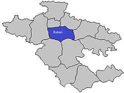
Rahuri taluka
| Rahuri taluka राहुरी तालुका | |
|---|---|
| Tehsil | |
 Location of Rahuri in Ahmednagar district in Maharashtra | |
| Country |
|
| State | Maharashtra |
| District | Ahmednagar district |
| Headquarters | Shrirampur |
| Government | |
| • Lok Sabha constituency | ahmednagar south |
| • Assembly constituency | rahuree |
| • MLA | kardile shivaji |
| Area | |
| • Total | 1,035.11 km2 (399.66 sq mi) |
| Population (2001) | |
| • Total | 294,748 |
| • Density | 280/km2 (740/sq mi) |
| Demographics | |
| • Literacy rate | 73.78 |
| Rain | 455 mm |
Rahuri taluka (Marathi: राहुरी तालुका), is a taluka in Shrirampur subdivision of Ahmednagar district in Maharashtra State of India.[1]
Area
The table below shows area of the taluka by land type.[2]
| Type of Land | Area (km2) | % of Total Area |
|---|---|---|
| Agriculture | 766.09 | 74.01 |
| Forest | 157.06 | 15.17 |
| Other | 111.96 | 10.82 |
| Total | 1035.11 | 100 |
Villages
There are around 96 villages in Rahuri taluka. For list of villages see Villages in Rahuri taluka.
Population
The table below shows population of the taluka by sex. The data is as per 2001 census.[3]
| Population | % of Total Population | Number of Literate | Literacy (% of Population) | |
|---|---|---|---|---|
| Male | 152275 | 51.66 | 112350 | 73.78 |
| Female | 142473 | 48.34 | 81148 | 56.96 |
| Total | 294748 | 100 | 193498 | 65.65 |
Rain Fall
The Table below details of rainfall from year 1981 to 2004.[4]
| Year | Rainfall (mm) |
|---|---|
| 1981 | 639 |
| 1982 | 434 |
| 1983 | 665 |
| 1984 | 427 |
| 1985 | 301 |
| 1986 | 242 |
| 1987 | 533 |
| 1988 | 725 |
| 1989 | 524 |
| 1990 | 788 |
| 1991 | 466 |
| 1992 | 407 |
| 1993 | 548 |
| 1994 | 455 |
| 1995 | 642 |
| 1996 | 555 |
| 1997 | 345 |
| 1998 | 585 |
| 1999 | 581 |
| 2000 | 587 |
| 2001 | 358 |
| 2002 | 302 |
| 2003 | 299 |
| 2004 | 509 |
See also
References
Ahmednagar district topics | ||
|---|---|---|
| History | 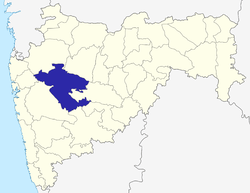 | |
| Geography | ||
| Talukas | ||
| Cities and towns | ||
| Monuments | ||
| Education | ||
| Lok Sabha constituencies | ||
| Vidhan Sabha constituencies | ||
| Dams in District | ||
This article is issued from Wikipedia - version of the 11/10/2016. The text is available under the Creative Commons Attribution/Share Alike but additional terms may apply for the media files.