Rensselaer Courthouse Square Historic District
|
Rensselaer Courthouse Square Historic District | |
|
Rensselaer Courthouse Square Historic District, April 2012 | |
  | |
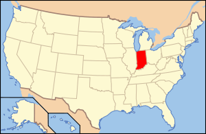
| Location | Roughly between Cullen and Front Sts. along W. Washington St., Rensselaer, Indiana |
|---|---|
| Coordinates | 40°56′10″N 87°09′07″W / 40.93611°N 87.15194°WCoordinates: 40°56′10″N 87°09′07″W / 40.93611°N 87.15194°W |
| Area | 36.5 acres (14.8 ha) |
| Built | 1868 |
| Architect | Grindle & Weatherhogg; Thompson, Simon; Coen, A. Wasson |
| Architectural style | Italianate, Romanesque, Classical Revival |
| NRHP Reference # | 12000185[1] |
| Added to NRHP | April 10, 2012 |
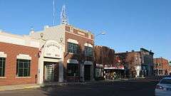
Rensselaer Courthouse Square Historic District is a national historic district located at Rensselaer, Jasper County, Indiana. It encompasses 37 contributing buildings, 2 contributing structures, and 3 contributing objects in the central business district of Rensselaer. The district developed between about 1868 and 1955, and includes notable examples of Italianate, Romanesque Revival, Gothic Revival, Classical Revival, Art Deco, and Modern style architecture. Located in the district is the separately listed Jasper County Courthouse. Other notable buildings include the Mobil Service Station (1955), Murray Building (1906), A. Leopold Building (1881), First National Bank Building (1917), IOOF Lodge (1895), Eigelsbach Building (1899), Eger Grocery (c. 1930), and Worden Building (1928).[2]
It was listed on the National Register of Historic Places in 2012.[1]
References
- 1 2 "National Register of Historic Places Listings". Weekly List of Actions Taken on Properties: 4/09/12 through 4/13/12. National Park Service. 2012-04-20.
- ↑ "Indiana State Historic Architectural and Archaeological Research Database (SHAARD)" (Searchable database). Department of Natural Resources, Division of Historic Preservation and Archaeology. Retrieved 2016-04-01. Note: This includes Kurt West Garner (August 2010). "National Register of Historic Places Inventory Nomination Form: Rensselaer Courthouse Square Historic District" (PDF). Retrieved 2016-04-01. and Accompanying photographs.