Resnik, Belgrade
| Resnik Ресник | |
|---|---|
|
One part of Resnik in 2002. | |
 Resnik Ресник | |
| Coordinates: 44°44′13″N 20°25′13″E / 44.73694°N 20.42028°E | |
| Country |
|
| District |
|
| Municipality |
|
| Time zone | CET (UTC+1) |
| • Summer (DST) | CEST (UTC+2) |
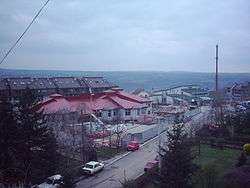
Resnik (Serbian Cyrillic: Ресник, Serbian pronunciation: [rɛ̂ːsnik]) is an urban neighborhood of Belgrade, the capital of Serbia. It is located in Belgrade's municipality of Rakovica.
Location and history
Resnik is located in the southern section of the municipality and makes the southernmost point of the urban Belgrade City Proper. Originally a village distant from Belgrade, which developed between the valleys of the creek of Rakovički potok and the Topčiderka river. The creek of Pariguz flows through the southern parts of Resnik before it empties into the Topčiderka. The settlement is roughly triangularly shaped and bordered by the settlements of Sunčani Breg, Jelezovac, Straževica (north) and Kijevo (north-west) which make Resnik's urban connection to the rest of Belgrade. The other three sides are still not urbanized (fields of Klik, Mandrine, Hladna Voda, Pašinac, etc.).
The village of Resnik had a population of 1,475 in 1921. In 1971, now a suburb of Belgrade, Resnik had 7,553 inhabitants while in 1981, already a local community (mesna zajednica) within Belgrade the population almost doubled to 14,122, while in 2002 reached 16,304.
Characteristics
Resnik is predominantly residential settlement. It is close to the important traffic routes: the valley of Rakovički potok is a route to the Kružni put, suburban road of Belgrade and the future part of the projected Belgrade beltway, and a Belgrade-Požarevac railway, while the valley of Topčiderka is a route to the Belgrade-Niš railway. Resnik has a railway stations on both railways (northern one is officially styled Jajinci but it is far from that neighborhood). Tunnels are constructed on both road and railway passing through the northern section of Resnik.
The building industry develops along the Kružni put as a series of construction companies, cement plants and a building material's depots are located there. An open green market (kvantaš) is also located on the road.
The artificial lake Pariguz is a well-known attraction in the area. It was made in 1989/90 and named after the nearby creek. It is a popular summer destination for many inhabitants of Resnik and for Belgraders who have weekend-houses in the area, even though the water was never tested and the banks are not arranged. Lake Pariguz was the proposed site of the 3rd European Peoples Global Action held in 2004, before it was moved to Jajinci.[1][2]
Future
In September 2007 an official motion was started by the municipality of Voždovac to create new sub-Avalan municipality (Avalski Venac), which would include the settlements of Ripanj, Beli Potok, Pinosava and Zuce from Voždovac, Vrčin from the municipality of Grocka and Resnik.[3][4]
References
- ↑ BeyondMayDay: Over the Resnik Horizon
- ↑ all4all.org | PGA conference in Europe organization summary
- ↑ Politika (in Serbian), p. 27, 2007-10-20 Missing or empty
|title=(help) - ↑ Večernje Novosti (in Serbian), p. 17, 2007-10-23 Missing or empty
|title=(help)
| Wikimedia Commons has media related to Resnik. |
Coordinates: 44°42′47″N 20°27′27″E / 44.71306°N 20.45750°E