Richland Township, Wyandot County, Ohio
| Richland Township, Wyandot County, Ohio | |
|---|---|
| Township | |
|
Big Oak Methodist Church on County Road 330 | |
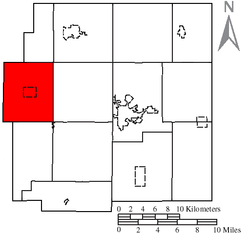 Location of Richland Township in Wyandot County | |
| Coordinates: 40°51′42″N 83°28′28″W / 40.86167°N 83.47444°WCoordinates: 40°51′42″N 83°28′28″W / 40.86167°N 83.47444°W | |
| Country | United States |
| State | Ohio |
| County | Wyandot |
| Area | |
| • Total | 30.3 sq mi (78.6 km2) |
| • Land | 30.3 sq mi (78.6 km2) |
| • Water | 0.0 sq mi (0.0 km2) |
| Elevation[1] | 876 ft (267 m) |
| Population (2000) | |
| • Total | 952 |
| • Density | 31.4/sq mi (12.1/km2) |
| Time zone | Eastern (EST) (UTC-5) |
| • Summer (DST) | EDT (UTC-4) |
| FIPS code | 39-66782[2] |
| GNIS feature ID | 1087210[1] |

Richland Township is one of the thirteen townships of Wyandot County, Ohio, United States. The 2000 census found 952 people in the township, 543 of whom lived in the unincorporated portions of the township.[3]
Geography
Located in the western part of the county, it borders the following townships:
- Ridge Township - north
- Crawford Township - northeast corner
- Salem Township - east
- Mifflin Township - southeast corner
- Jackson Township - south
- Jackson Township, Hardin County - southwest
- Delaware Township, Hancock County - west
- Amanda Township, Hancock County - northwest
Two villages are located in Richland Township: Wharton in the center, and part of Forest in the southwest along the border with Hardin County.
Name and history
It is one of twelve Richland Townships statewide.[4]
Government
The township is governed by a three-member board of trustees, who are elected in November of odd-numbered years to a four-year term beginning on the following January 1. Two are elected in the year after the presidential election and one is elected in the year before it. There is also an elected township fiscal officer,[5] who serves a four-year term beginning on April 1 of the year after the election, which is held in November of the year before the presidential election. Vacancies in the fiscal officership or on the board of trustees are filled by the remaining trustees.
References
- 1 2 "US Board on Geographic Names". United States Geological Survey. 2007-10-25. Retrieved 2008-01-31.
- ↑ "American FactFinder". United States Census Bureau. Archived from the original on September 11, 2013. Retrieved 2008-01-31.
- ↑ Wyandot County, Ohio — Population by Places Estimates Ohio State University, 2007. Accessed 15 May 2007.
- ↑ "Detailed map of Ohio" (PDF). United States Census Bureau. 2000. Retrieved 2007-02-16.
- ↑ §503.24, §505.01, and §507.01 of the Ohio Revised Code. Accessed 4/30/2009.
External links
Municipalities and communities of Wyandot County, Ohio, United States | ||
|---|---|---|
| City | 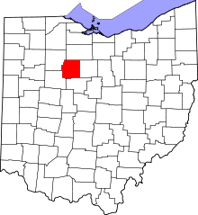 | |
| Villages | ||
| Townships | ||
| CDP | ||
| Unincorporated communities | ||
| Footnotes | ‡This populated place also has portions in an adjacent county or counties. | |