Ringgold, Ohio
For the community in Pickaway County, see East Ringgold, Ohio.
| Ringgold, Ohio | |
|---|---|
| Unincorporated community | |
|
State Route 78 in the community's east side | |
 Ringgold, Ohio | |
| Coordinates: 39°35′25″N 81°58′47″W / 39.59028°N 81.97972°WCoordinates: 39°35′25″N 81°58′47″W / 39.59028°N 81.97972°W | |
| Country | United States |
| State | Ohio |
| County | Morgan |
| Elevation | 922 ft (281 m) |
| Time zone | Eastern (EST) (UTC-5) |
| • Summer (DST) | EDT (UTC-4) |
| Area code(s) | 740 |
| GNIS feature ID | 1076743[1] |

Ringgold is an unincorporated community in Morgan County, Ohio, United States. Ringgold is located at the junction of State Routes 78 and 555, 7.5 miles (12.1 km) southwest of Malta.
History
Ringgold was platted in 1846, and named for Samuel Ringgold, a United States Army officer.[2] A post office was established at Ringgold in 1847, and remained in operation until 1939.[3]
References
- ↑ U.S. Geological Survey Geographic Names Information System: Ringgold, Ohio
- ↑ Robertson, Charles (1886). History of Morgan County, Ohio, with Portraits and Biographical Sketches of Some of Its Pioneers and Prominent Men. L. H. Watkins & Company. p. 495.
- ↑ "Morgan County". Jim Forte Postal History. Retrieved December 2015. Check date values in:
|access-date=(help)
Municipalities and communities of Morgan County, Ohio, United States | ||
|---|---|---|
| Villages | 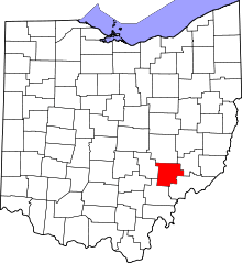 | |
| Townships | ||
| Unincorporated communities | ||
This article is issued from Wikipedia - version of the 10/13/2016. The text is available under the Creative Commons Attribution/Share Alike but additional terms may apply for the media files.