Riverton Township, Fremont County, Iowa
| Riverton Township | |
|---|---|
| Township | |
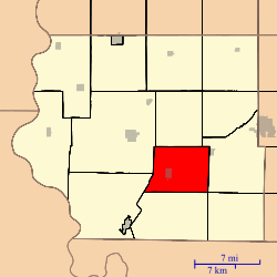 Location in Fremont County | |
| Coordinates: 40°41′32″N 95°32′41″W / 40.69222°N 95.54472°WCoordinates: 40°41′32″N 95°32′41″W / 40.69222°N 95.54472°W | |
| Country | United States |
| State | Iowa |
| County | Fremont |
| Area | |
| • Total | 29.95 sq mi (77.57 km2) |
| • Land | 28.67 sq mi (74.25 km2) |
| • Water | 1.28 sq mi (3.32 km2) 4.28% |
| Elevation | 928 ft (283 m) |
| Population (2010)[1] | |
| • Total | 380 |
| • Density | 13.3/sq mi (5.1/km2) |
| Time zone | CST (UTC-6) |
| • Summer (DST) | CDT (UTC-5) |
| ZIP codes | 51639, 51640, 51650, 51652 |
| GNIS feature ID | 0468625[2] |
Riverton Township is one of thirteen townships in Fremont County, Iowa, United States. As of the 2010 census, its population was 380 and it contained 181 housing units.[1]
Geography
As of the 2010 census, Riverton Township covered an area of 29.95 square miles (77.6 km2); of this, 28.67 square miles (74.3 km2) (95.72 percent) was land and 1.28 square miles (3.3 km2) (4.28 percent) was water.[1]
Cities, towns, villages
Cemeteries
The township contains Riverton Cemetery.[3]
School districts
- Farragut Community School District
- Hamburg Community School District
- Sidney Community School District
Political districts
- Iowa's 3rd congressional district
- State House District 23
- State Senate District 12
References
- "TIGER/Line Shapefiles". United States Census Bureau.
- 1 2 3 "2010 Census Gazetteer". United States Census Bureau. Retrieved 2014-02-23.
- ↑ "Riverton Township, Fremont County, Iowa". Geographic Names Information System. United States Geological Survey. Retrieved 2014-02-23.
- ↑ "Riverton Cemetery". Geographic Names Information System. United States Geological Survey. Retrieved 2014-02-23.
External links
 |
Sidney Township | Prairie Township | | |
| Washington Township | |
Fisher Township | ||
| ||||
| | ||||
| Madison Township | Locust Grove Township |
Municipalities and communities of Fremont County, Iowa, United States | ||
|---|---|---|
| Cities | ||
| Townships | ||
| CDPs | ||
| Other unincorporated community | ||
| Footnotes | ‡This populated place also has portions in an adjacent county or counties | |
This article is issued from Wikipedia - version of the 8/10/2016. The text is available under the Creative Commons Attribution/Share Alike but additional terms may apply for the media files.