Riverview Historic District (Selma, Alabama)
|
Riverview Historic District | |
|
View along Lamar Avenue in the district | |
  | |
| Location | Roughly bounded by Selma Ave., Satterfield and Lapsley Sts. and the Alabama River, Selma, Alabama |
|---|---|
| Coordinates | 32°24′11″N 87°01′50″W / 32.40306°N 87.03056°WCoordinates: 32°24′11″N 87°01′50″W / 32.40306°N 87.03056°W |
| Area | 86 acres (35 ha) |
| NRHP Reference # | 90000887[1] |
| Added to NRHP | June 28, 1990 |
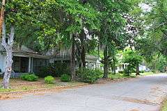
The Riverview Historic District is an 86-acre (35 ha) historic district in Selma, Dallas County, Alabama. It is bounded by Selma Avenue, Satterfield and Lapsley streets, and the Alabama River. The district includes examples of the Tudor Revival, Colonial Revival, American Craftsman, and several Queen Anne styles (Stick, Eastlake, and Shingle). Primarily residential, it contains 204 contributing properties and 54 noncontributing properties. The district is representative of the prosperity of people in the city at the turn of the 20th century. This time marked a period of major growth for the middle and working-class population.[2] The district was added to the National Register of Historic Places on June 28, 1990.[1]
References
- 1 2 National Park Service (July 9, 2010). "National Register Information System". National Register of Historic Places. National Park Service.
- ↑ "National Register of Historic Places Registration: Riverview Historic District" (PDF). National Park Service. Retrieved April 15, 2013. See also: "Accompanying photos" (PDF).
| Topics | |
|---|---|
| Lists by states |
|
| Lists by insular areas | |
| Lists by associated states | |
| Other areas | |
| |
This article is issued from Wikipedia - version of the 11/30/2016. The text is available under the Creative Commons Attribution/Share Alike but additional terms may apply for the media files.