Rivière-Bonjour, Quebec
| Rivière-Bonjour | |
|---|---|
| Unorganized territory | |
 | |
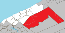 Location within La Matanie RCM. | |
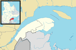 Rivière-Bonjour Location in eastern Quebec. | |
| Coordinates: 48°46′N 66°55′W / 48.767°N 66.917°WCoordinates: 48°46′N 66°55′W / 48.767°N 66.917°W[1] | |
| Country |
|
| Province |
|
| Region | Bas-Saint-Laurent |
| RCM | La Matanie |
| Constituted | January 1, 1986 |
| Government[2] | |
| • Federal riding | Haute-Gaspésie—La Mitis—Matane—Matapédia |
| • Prov. riding | Matane-Matapédia |
| Area[2][3] | |
| • Total | 1,679.50 km2 (648.46 sq mi) |
| • Land | 1,681.79 km2 (649.34 sq mi) |
|
There is an apparent contradiction between two authoritative sources | |
| Population (2011)[3] | |
| • Total | 10 |
| • Density | 0.0/km2 (0/sq mi) |
| • Pop 2006-2011 |
|
| • Dwellings | 145 |
| Time zone | EST (UTC-5) |
| • Summer (DST) | EDT (UTC-4) |
| Area code(s) | 418 and 581 |
| Highways |
|
Rivière-Bonjour is an unorganized territory in the Bas-Saint-Laurent region of Quebec, Canada. A large part of the territory is part of the Matane Wildlife Reserve.
The eponymous Bonjour River is a 15 kilometres (9.3 mi) long stream roughly in the centre of the territory that has its source at the south-eastern slopes of the Chic-Choc Mountains, including the 1,065 metres (3,494 ft) high Mont Blanc. The stream joins the Matane River at Matane Lake.[4]
Demographics
Population
| Canada census – Rivière-Bonjour, Quebec community profile | |||
|---|---|---|---|
| 2011 | 2006 | 2001 | |
| Population: | 10 (-33.3% from 2006) | 15 (+n/a% from 2001) | 0 (0.0% from 1996) |
| Land area: | 1,681.79 km2 (649.34 sq mi) | 1,681.79 km2 (649.34 sq mi) | 1,681.79 km2 (649.34 sq mi) |
| Population density: | 0.0/km2 (0/sq mi) | 0.0/km2 (0/sq mi) | 0.0/km2 (0/sq mi) |
| Median age: | N/A (M: , F: ) | N/A (M: , F: ) | N/A (M: , F: ) |
| Total private dwellings: | 145 | 35 | 118 |
| Median household income: | $.N/A | $.N/A | $.N/A |
| Notes: Median age & income data for this area has been suppressed for data quality or confidentiality reasons. – References: 2011[3] 2006[5] 2001[6] | |||
| Historical Census Data - Rivière-Bonjour, Quebec[7] | ||||||||||||||||||||||||||||||||||
|---|---|---|---|---|---|---|---|---|---|---|---|---|---|---|---|---|---|---|---|---|---|---|---|---|---|---|---|---|---|---|---|---|---|---|
|
|
|
|
| ||||||||||||||||||||||||||||||
.JPG)
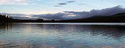
Lake Matane in the Matane Wildlife Reserve
See also
References
- ↑ Reference number 149686 of the Commission de toponymie du Québec (French)
- 1 2 "Rivière-Bonjour". Répertoire des municipalités (in French). Ministère des Affaires municipales, des Régions et de l'Occupation du territoire. Retrieved 2012-01-17.
- 1 2 3 "Rivière-Bonjour census profile". 2011 Census data. Statistics Canada. Retrieved 2012-01-17.
- ↑ "Rivière Bonjour" (in French). Commission de toponymie du Québec. Retrieved 2012-01-24.
- ↑ "2006 Community Profiles". Canada 2006 Census. Statistics Canada. March 30, 2011. Retrieved 2014-02-08.
- ↑ "2001 Community Profiles". Canada 2001 Census. Statistics Canada. February 17, 2012. Retrieved 2014-02-08.
- ↑ Statistics Canada: 1996, 2001, 2006, 2011 census
 |
Saint-René-de-Matane | St-Jean-de-Cherbourg, Les Méchins, Coulée-des-Adolphe | | |
| Saint-Vianney Lac-Casault |
|
Mont-Albert | ||
| ||||
| | ||||
| Ruisseau-des-Mineurs | Lac-Casault |
| Cities & Towns | |
|---|---|
| Municipalities | |
| Parishes | |
| Unorganized territories | |
| |
This article is issued from Wikipedia - version of the 2/8/2014. The text is available under the Creative Commons Attribution/Share Alike but additional terms may apply for the media files.