Roccamandolfi
| Roccamandolfi | |
|---|---|
| Comune | |
| Comune di Roccamandolfi | |
|
Roccamandolfi within the Province of Isernia | |
 Roccamandolfi Location of Roccamandolfi in Italy | |
| Coordinates: 41°30′N 14°21′E / 41.500°N 14.350°ECoordinates: 41°30′N 14°21′E / 41.500°N 14.350°E | |
| Country | Italy |
| Region | Molise |
| Province / Metropolitan city | Province of Isernia (IS) |
| Area | |
| • Total | 53.9 km2 (20.8 sq mi) |
| Population (Dec. 2004) | |
| • Total | 1,058 |
| • Density | 20/km2 (51/sq mi) |
| Time zone | CET (UTC+1) |
| • Summer (DST) | CEST (UTC+2) |
| Postal code | 86098 |
| Dialing code | 0865 |
.svg.png)
Roccamandolfi is a comune (municipality) in the Province of Isernia in the Italian region Molise, located about 25 kilometres (16 mi) southwest of Campobasso and about 15 kilometres (9 mi) southeast of Isernia. As of 31 December 2004, it had a population of 1,058 and an area of 53.9 square kilometres (20.8 sq mi).[1]
Geography
Roccamandolfi borders the following municipalities: Cantalupo nel Sannio, Castelpizzuto, Gallo Matese, Letino, Longano, San Gregorio Matese, San Massimo and Santa Maria del Molise.
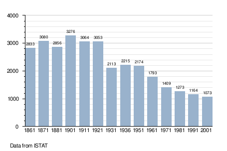
Demographic evolution
References
External links
![]() Media related to Roccamandolfi at Wikimedia Commons
Media related to Roccamandolfi at Wikimedia Commons
This article is issued from Wikipedia - version of the 6/27/2014. The text is available under the Creative Commons Attribution/Share Alike but additional terms may apply for the media files.