Rose Hill Farm (Upperville, Virginia)
|
Rose Hill Farm | |
 | |
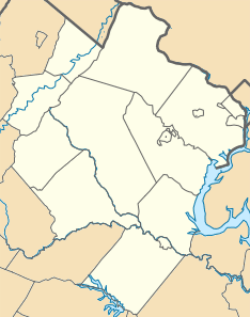   | |
| Location | North side of US 50, 1.5 miles (2.4 km) west of the junction with VA 713, Upperville, Virginia |
|---|---|
| Coordinates | 38°59′01″N 77°49′49″W / 38.98361°N 77.83028°WCoordinates: 38°59′01″N 77°49′49″W / 38.98361°N 77.83028°W |
| Area | 72 acres (29 ha) |
| Built | 1820 |
| Architectural style | Colonial Revival, Federal |
| NRHP Reference # | 94000986[1] |
| VLR # | 053-0001 |
| Significant dates | |
| Added to NRHP | August 25, 1994 |
| Designated VLR | June 15, 1994[2] |
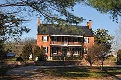
Rose Hill Farm is a home and farm located near Upperville, Loudoun County, Virginia. The original section of the house was built about 1820, and is 2 1/2-story, five bay, gable roofed brick dwelling in the Federal style. The front facade features an elaborate two-story porch with cast-iron decoration in a grape-vine pattern that was added possibly in the 1850s. Also on the property are the contributing 1 1/2-story, brick former slave quarters / smokehouse / dairy (c. 1820); one-story, log meat house; frame octagonal icehouse; 3 1/2-story, three-bay, gable-roofed, stone granary (1850s); a 19th-century, arched. stone bridge; family cemetery; and 19th century stone wall.[3]
It was listed on the National Register of Historic Places in 1994.[1]
References
- 1 2 National Park Service (2010-07-09). "National Register Information System". National Register of Historic Places. National Park Service.
- ↑ "Virginia Landmarks Register". Virginia Department of Historic Resources. Retrieved 5 June 2013.
- ↑ Geoffrey B. Henry (April 1994). "National Register of Historic Places Inventory/Nomination: Rose Hill Farm" (PDF). Virginia Department of Historic Resources. and Accompanying photo

This article is issued from Wikipedia - version of the 11/30/2016. The text is available under the Creative Commons Attribution/Share Alike but additional terms may apply for the media files.